The water-dependent asset register for the Maranoa-Balonne-Condamine subregion (Bioregional Assessment Programme, 2017) contains 135 sociocultural assets that are included in the water-dependent asset register that was used for the impact and risk analysis (updated 5 February 2016; Bioregional Assessment Programme, Dataset 2; Bioregional Assessment Programme, 2017). Of these 135 sociocultural assets, 79 were considered to be water dependent based on the presence of floodplain and wetland areas and shallow groundwater within their spatial extent as described in companion product 1.3 (Mitchell et al., 2015b). These 79 sociocultural assets include 39 built heritage assets, 11 war memorials, 3 Indigenous sites and 26 recreation areas, including national parks and areas of remnant vegetation (Table 34).
Separate reports are available on Indigenous water assets in the Queensland and NSW parts of the Maranoa-Balonne-Condamine subregion, which contributed to this Assessment. Following consultation with Traditional Owners in the Maranoa-Balonne-Condamine subregion, an additional 56 Indigenous assets were included in the water-dependent asset register used for the impact and risk analysis (updated 5 February 2016; Bioregional Assessment Programme, Dataset 2; Bioregional Assessment Programme, 2017). Of these, 35 Indigenous assets are cultural values associated with animals and plants that do not have geographic location information. This means they could not be specifically assessed for hydrological impact due to additional coal resource development using spatial overlay. None of the 35 cultural values associated with animals and plants are listed separately as ecological assets for the subregion. The cultural values and nature of the water dependency of these 35 Indigenous assets are described in Table 35.
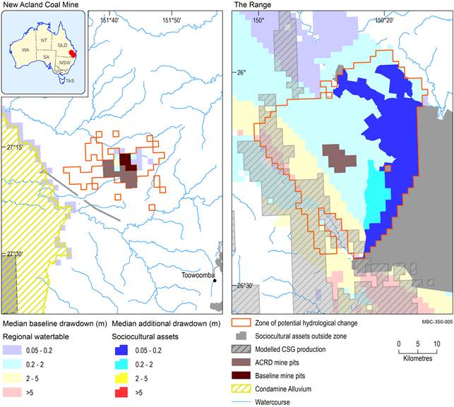
The zone of potential hydrological change includes part of one sociocultural asset – the 3092 km2 Barakula State Forest Area, near Miles in Queensland – which is classified as a recreation area (Table 34). It is considered to be water dependent based on the presence of floodplain and wetland areas and shallow groundwater within its spatial extent. The Barakula State Forest is located along the eastern edge of the zone of potential hydrological change in the vicinity of The Range coal mine (Figure 44).
Table 34 Number of sociocultural water-dependent assets in the assessment extent and zone of potential hydrological change
aOut of the total 59 Indigenous sites, 35 are Indigenous cultural values associated with animals and plants that do not have geographic location information, which means they cannot be specifically assessed for hydrological impact due to additional coal resource development. Therefore ‘–‘ (not applicable) is indicated for whether these assets are in the zone, because it is unknown whether the aspatial assets are in the zone.
Data: Bioregional Assessment Programme (Dataset 2, Dataset 3)
Table 35 Description of cultural values and nature of water dependency for Indigenous assets
aPunctuation and typography appear as used in the asset database.
Data: Bioregional Assessment Programme (Dataset 2)
Baseline drawdown is the maximum difference in drawdown (dmax) under the baseline relative to no coal resource development. Additional drawdown is the maximum difference in drawdown (dmax) between the coal resource development pathway (CRDP) and baseline, due to additional coal resource development. The mine pits in the CRDP are the sum of those in the baseline and the additional coal resource development. Areas within modelled open-cut mine pits (Table 4) are not included in this analysis.
ACRD = additional coal resource development, CSG = coal seam gas
Data: Bioregional Assessment Programme (Dataset 2, Dataset 4, Dataset 5, Dataset 6, Dataset 7, Dataset 8)
The zone of potential hydrological change, where there is a greater than 5% chance of exceeding 0.2 m drawdown due to additional coal resource development, includes 465 km2 of the Barakula State Forest (Table 36 and Figure 45). Median drawdown due to additional coal resource development is less than 2 m, and predominantly less than 2 m under the baseline, with the exception of 13 km2 to the south-west of The Range coal mine (Table 36 and Table 37).
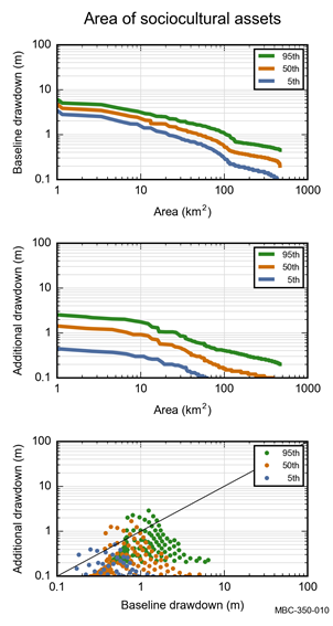
Colours represent the 5th, 50th and 95th percentile. Baseline drawdown is the maximum difference in drawdown (dmax) under the baseline relative to no coal resource development. Additional drawdown is the maximum difference in drawdown (dmax) between the coal resource development pathway (CRDP) and baseline, due to additional coal resource development. Areas within modelled open-cut mine pits (Table 4) are not included in this analysis.
Data: Bioregional Assessment Programme (Dataset 3)
Table 36 Number and extent of sociocultural assets that exceed the 5th, 50th and 95th percentile estimates of baseline drawdown (m) in the zone of potential hydrological change
aNumbers in table are italicised, to distinguish from areas. Numbers within the whole zone are included in this analysis.
bLengths or areas within modelled open-cut mine pits (Table 4) are not included in this analysis.
cOut of the total 59 Indigenous sites, these 35 are Indigenous cultural values associated with animals and plants that do not have geographic location information, which means they cannot be specifically assessed for hydrological impact due to additional coal resource development.
dExtent could be a number, length or area.
‘–’ means ‘not applicable’. The extent potentially exposed to ≥0.2, ≥2 and ≥5 m baseline drawdown is shown for the 5th, 50th and 95th percentile estimates. Baseline drawdown is the maximum difference in drawdown (dmax) under the baseline relative to no coal resource development. The zone of potential hydrological change is defined as the area with a greater than 5% chance of exceeding 0.2 m drawdown due to additional coal resource development.
Data: Bioregional Assessment Programme (Dataset 3)
Table 37 Number and extent of sociocultural assets that exceed the 5th, 50th and 95th percentile estimates of additional drawdown (m) in the zone of potential hydrological change
aNumbers in table are italicised, to distinguish from areas. Numbers within the whole zone are included in this analysis.
bLengths or areas within modelled open-cut mine pits (Table 4) are not included in this analysis.
cOut of the total 59 Indigenous sites, these 35 are Indigenous cultural values associated with animals and plants that do not have geographic location information, which means they could not be specifically assessed for hydrological impact due to additional coal resource development.
dExtent could be a number, length or area.
‘–’ means ‘not applicable’. The extent potentially exposed to ≥0.2, ≥2 and ≥5 m additional drawdown is shown for the 5th, 50th and 95th percentile estimates of the maximum difference in drawdown (dmax) between the coal resource development pathway (CRDP) and baseline, due to additional coal resource development. The zone of potential hydrological change is defined as the area with a greater than 5% chance of exceeding 0.2 m drawdown due to additional coal resource development.
Data: Bioregional Assessment Programme (Dataset 3)
