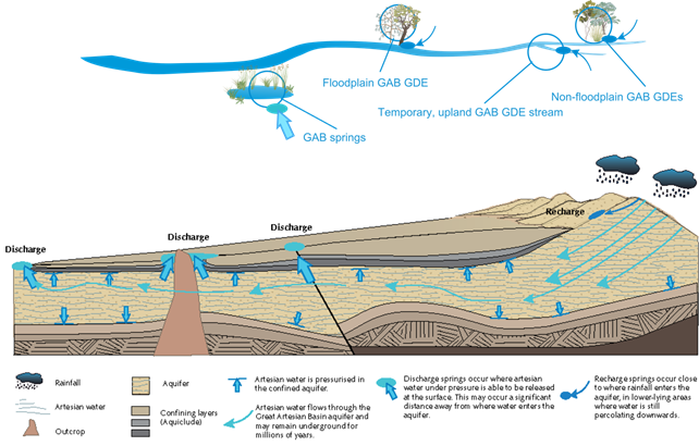
Ecosystems that are hydrologically connected to GAB aquifers include springs, streams, floodplains and non-floodplain areas (Figure 27). This landscape group contains very small areas of wetland habitat (10 km2, <1% of all wetlands in the assessment extent). GAB GDEs can occur on both floodplain and non-floodplain areas and include near-permanent and temporary wetlands where groundwater is expressed at the surface. Groundwater recharge into the GAB aquifers occurs along sandstone outcrop areas that can include hilly upland areas, where rainwater percolates into the GAB aquifers between confining layers (Figure 27). However, fractures, inter-granular pores and weathered zones can cause groundwater to discharge locally at or near the surface in these areas (DSITI, 2015). The discharge of localised recharge is termed ‘rejected recharge’. Approximately 1.3% of the vegetation and 13% of the stream network in the assessment extent are hydrologically connected to GAB aquifers (Table 8).
GAB springs may form surface water bodies that support aquatic ecosystems and typically contain endemic species and plant communities that have significant ecological, economic and cultural values (Fensham and Fairfax, 2003). GAB springs can be associated with faults or aquitards, thinning of the confining layer or topographic conditions, such as a change of slope or a depression into an aquifer, that allow groundwater to discharge at the surface (QWC, 2012). Based on their hydrogeological setting, GAB springs can be classed as recharge or discharge springs. Recharge springs form where GAB aquifers outcrop at the surface, typically in the recharge zones on the eastern margins of the GAB (Figure 27) (Fensham and Fairfax, 2003). All other springs associated with GAB aquifers, known as discharge springs, are associated with faults or where GAB aquifers are expressed at the surface, and tend to occur down gradient of recharge areas (Figure 27) (Fensham and Fairfax, 2003). There are 153 GAB springs identified in the assessment extent (Table 8).
GAB = Great Artesian Basin, GDE = groundwater-dependent ecosystem
Source: DEHP (2013b), symbols courtesy of the Integration and Application Network (ian.umces.edu/symbols/)
The zone of potential hydrological change contains four landscape classes in the ‘GAB GDEs (riverine, springs, floodplain or non-floodplain)’ landscape group (Table 8). These are ‘Floodplain GAB GDE’, ‘Non-floodplain GAB GDE’, ‘Temporary lowland GAB GDE stream’ and ‘Temporary upland GAB GDE stream’. The ‘Floodplain, GAB GDE’ and ‘Temporary, lowland GAB GDE stream’ landscape classes occur where local discharge from sandstone outcrop areas supports vegetation overlying or adjacent to alluvial sediments. Floodplain and lowland GAB GDEs have greater lateral connectivity with the alluvial sediments and stream channels, as well as accessing groundwater sources derived from the neighbouring sandstone outcropping areas. Temporary, lowland GAB GDE streams support riparian poplar box (E. populnea) woodlands.
Non-floodplain GAB GDEs include woodland communities reliant on groundwater discharge from sandstone outcrops (land zones 9 and 10), sandy plains and lateritic duricrusts (land zones 5 and 7) (DSITI, 2015). Groundwater that is accessed by the root zones of Corymbia and Eucalyptus dominated woodlands originates from localised recharge areas upslope of the GDEs. These GDEs are often adjacent to temporary upland GAB GDE streams; aquatic systems that may also receive ‘rejected recharge’.
The selection of hydrological response variables for the ‘GAB GDEs (riverine, springs, floodplain or non-floodplain)’ landscape group is based on the ecohydrological conceptualisation developed for the Queensland GDE mapping and literature on the response of floodplain vegetation condition to changes in the hydrological regime (Table 12).
Hydrological response variables identified by the Assessment team for the ‘GAB GDEs (riverine, springs, floodplain or non-floodplain)’ landscape group are maximum drawdown in the regional watertable, annual amplitude of drawdown, rate of annual drawdown and change to groundwater quality. Groundwater discharge to streams also supports the maintenance of flow regimes to support the channel habitat. The temporary nature of many streams in this landscape group means that changes to the magnitude and duration of high and low flows, and frequency of flood pulses will affect lateral and longitudinal connectivity within the channel and floodplain environment.
Springs may be affected by hydrological changes in deeper geological layers, which may have ecological repercussions for surface ecosystems surrounding springs. Springs in the subregion
provide unique ecological habitats and contain rare and threatened species. In addition, groundwater discharge can sustain waterholes and watercourses where the discharge plays an important role in maintaining stream ecosystem functions and processes (OGIA, 2016, p. 103).
To protect these sensitive ecosystems, Queensland’s Water Act 2000 requires prevention or mitigation options to be developed for springs where predicted pressure reductions in the source aquifer are greater than 0.2 m. This is consistent with NSW’s Aquifer Interference Policy, where high-priority GDEs and culturally significant sites in the GAB are managed using a 0.2 m drawdown threshold (DPI, 2012). This 0.2 m drawdown threshold is also close to the practical resolution limits of modelled and measured drawdown, within the bounds of seasonal and climatic variability.
Table 12 Ecological relevance of hydrological changes for landscape classes in the ‘GAB GDEs (riverine, springs, floodplain, non-floodplain)’ landscape group that are contained within the zone of potential hydrological change
GAB = Great Artesian Basin, GDE = groundwater-dependent ecosystem

Product Finalisation date
- 3.1 Overview
- 3.2 Methods
- 3.3 Potential hydrological changes
- 3.4 Impacts on and risks to landscape classes
- 3.4.1 Overview
- 3.4.2 Landscape classes that are unlikely to be impacted
- 3.4.3 'Floodplain or lowland riverine (including non-GAB GDEs)' landscape group
- 3.4.4 'GAB GDEs (riverine, springs, floodplain or non-floodplain)' landscape group
- 3.4.5 'Non-floodplain or upland riverine (including non-GAB GDEs)' landscape group
- 3.4.6 'Human-modified' landscape group
- References
- Datasets
- 3.5 Impacts on and risks to water-dependent assets
- 3.6 Commentary for coal resource developments that are not modelled
- 3.7 Conclusion
- Citation
- Acknowledgements
- Contributors to the Technical Programme
- About this technical product

