3.4.6.2.1 Groundwater
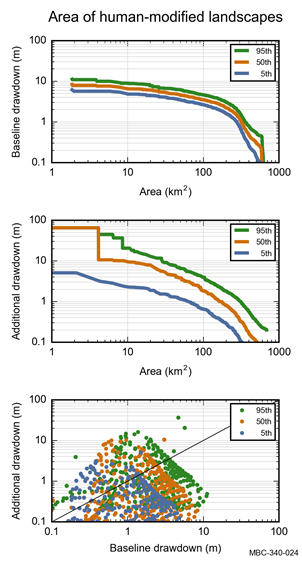
There is 685 km2 of non-remnant vegetation in the ‘Human-modified’ landscape group contained within the zone of potential hydrological change (Figure 33 and Table 8). Non-remnant vegetation in the zone of potential hydrological change (excluding open-cut mine pits) is predominantly classified as ‘Production from relatively natural environments’ (541 km2) or ‘Production from dryland agriculture and plantations’ (140 km2).
The median (50th percentile) estimate of exceeding 0.2 m drawdown due to additional coal resource development includes 371 km2 of human-modified landscapes (Table 20). The area potentially affected by median additional drawdown in excess of 2 m is 92 km2. Median additional drawdown is less than 5 m, with the exception of 32 km2 of human-modified landscapes in the immediate vicinity of the operational areas (Figure 33).
Median drawdown under the baseline is predominantly less than 2 m, covering 223 km2 of the 685 km2 of human-modified landscapes in the zone of potential hydrological change (Figure 34 and Table 19). Median drawdown under the baseline in excess of 5 m, associated with CSG development to the west of The Range proposed coal mine, covers 36 km2 of human-modified landscapes located along the south-western edge of the zone of potential hydrological change (Figure 33).
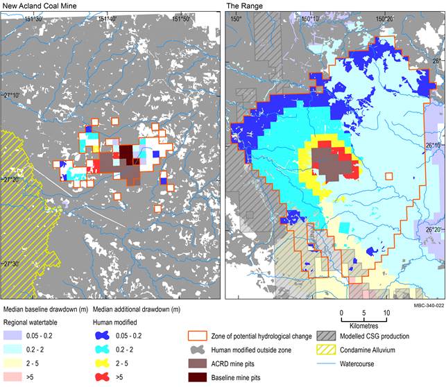
Baseline drawdown is the maximum difference in drawdown (dmax) under the baseline relative to no coal resource development. Additional drawdown is the maximum difference in drawdown (dmax) between the coal resource development pathway (CRDP) and baseline, due to additional coal resource development. The mine pits in the CRDP are the sum of those in the baseline the additional coal resource development. Landscape classes within modelled open-cut mine pits are not included in this analysis.
ACRD = additional coal resource development, CSG = coal seam gas
Data: Bioregional Assessment Programme (Dataset 1, Dataset 2, Dataset 3, Dataset 4, Dataset 8, Dataset 9)
Baseline drawdown is the maximum difference in drawdown (dmax) under the baseline relative to no coal resource development. Additional drawdown is the maximum difference in drawdown (dmax) between the coal resource development pathway (CRDP) and baseline, due to additional coal resource development. Landscape classes within modelled open-cut mine pits are not included in this analysis.
Data: Bioregional Assessment Programme (Dataset 7)
Table 19 ‘Human-modified’ landscape group: area (km2) that exceeds the 5th, 50th and 95th percentile estimates of baseline drawdown in the zone of potential hydrological change
aNumbers exclude the modelled open-cut mine pits.
Baseline drawdown is the maximum difference in drawdown (dmax) under the baseline relative to no coal resource development. Landscape classes within modelled open-cut mine pits are not included in this analysis. Due to rounding, some totals may not correspond with the sum of the separate numbers.
Data: Bioregional Assessment Programme (Dataset 7)
Table 20 ‘Human-modified’ landscape group: area (km2) that exceeds the 5th, 50th and 95th percentile estimates of additional drawdown in the zone of potential hydrological change
aNumbers exclude the modelled open-cut mine pits.
Additional drawdown is the maximum difference in drawdown (dmax) between the coal resource development pathway (CRDP) and baseline, due to additional coal resource development. Landscape classes within modelled open-cut mine pits are not included in this analysis. Due to rounding, some totals may not correspond with the sum of the separate numbers.
Data: Bioregional Assessment Programme (Dataset 7)
3.4.6.2.2 Surface water
No surface water numerical modelling was undertaken for the Maranoa-Balonne-Condamine subregion. Some potential hydrological changes may, however, be specified conceptually based on scientific logic as described in Section 3.3 (Potential hydrological impacts).
