3.4.3.2.1 Groundwater
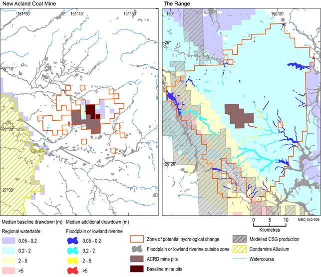
Outside the modelled open-cut mine pits, floodplain or lowland riverine landscapes that are potentially impacted cover 20 km2 (which is 0.3% of the ‘Floodplain or lowland riverine’ landscape group in the assessment extent) of remnant vegetation and 299 km (1.0%) of streams, which are predominantly not groundwater dependent (Figure 25 and Table 8). Temporary lowland streams in the zone of potential hydrological change include Dogwood and Rocky creeks to the south-west of The Range coal mine that flow into the Condamine and Balonne rivers.
Median additional drawdown is less than 2 m, with the exception of 0.2 km2 of remnant vegetation and 20 km of streams near the open-cut coal mine pits (Table 11), where median additional drawdown in the regional watertable is up to 65 m near New Acland Coal Mine and up to 10.2 m near The Range coal mine. Median baseline drawdown in the zone of potential hydrological change is predominantly greater than 2 m, containing 8 km2 of remnant vegetation and 112 km of streams (Figure 25 and Table 10).
Drawdown under the baseline is greater than due to additional coal resource development for most remnant vegetation and streams in the ‘Floodplain or lowland riverine’ landscape group (Figure 26). This is consistent with their location near the outer edges of the zone of potential hydrological change, where additional drawdown is less.
Median is the 50th percentile. Baseline drawdown is the maximum difference in drawdown (dmax) under the baseline relative to no coal resource development. Additional drawdown is the maximum difference in drawdown (dmax) between the coal resource development pathway (CRDP) and baseline, due to additional coal resource development. The mine pits in the CRDP are the sum of those in the baseline and the additional coal resource development. Landscape classes within modelled pits are not included in this analysis.
ACRD = additional coal resource development, CSG = coal seam gas, GAB = Great Artesian Basin, GDE = groundwater-dependent ecosystem
Data: Bioregional Assessment Programme (Dataset 1, Dataset 2, Dataset 3, Dataset 4, Dataset 8, Dataset 9)
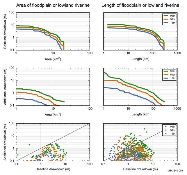
Colours represent the 5th, 50th and 95th percentile. Baseline drawdown is the maximum difference in drawdown (dmax) under the baseline relative to no coal resource development. Additional drawdown is the maximum difference in drawdown (dmax) between the coal resource development pathway (CRDP) and baseline, due to additional coal resource development. Areas within modelled open-cut mine pits are not included in this analysis.
GAB = Great Artesian Basin, GDE = groundwater-dependent ecosystem
Data: Bioregional Assessment Programme (Dataset 7)
Table 10 ‘Floodplain or lowland riverine (including non-GAB GDEs)’ landscape group: area (km2) or stream network length (km) that exceeds the 5th, 50th and 95th percentile estimates of baseline drawdown in the zone of potential hydrological change
aExtent could be length or area and excludes modelled open-cut mine pits.
Baseline drawdown is the maximum difference in drawdown (dmax) under the baseline relative to no coal resource development. Landscape classes within modelled open-cut mine pits are not included in this analysis. Due to rounding, some totals may not correspond with the sum of the separate numbers.
GAB = Great Artesian Basin, GDE = groundwater-dependent ecosystem
Data: Bioregional Assessment Programme (Dataset 7)
Table 11 ‘Floodplain or lowland riverine (including non-GAB GDEs)’ landscape group: area (km2) or stream network length (km) that exceeds the 5th, 50th and 95th percentile estimates of additional drawdown in the zone of potential hydrological change
aExtent could be a length or area and excludes modelled open-cut mine pits.
Additional drawdown is the maximum difference in drawdown (dmax) between the coal resource development pathway (CRDP) and baseline, due to additional coal resource development. Landscape classes within modelled open-cut mine pits are not included in this analysis. Due to rounding, some totals may not correspond with the sum of the separate numbers.
GAB = Great Artesian Basin, GDE = groundwater-dependent ecosystem
Data: Bioregional Assessment Programme (Dataset 7)
3.4.3.2.2 Surface water
No surface water numerical modelling was undertaken for the Maranoa-Balonne-Condamine subregion. Some potential hydrological changes may, however, be specified conceptually based on scientific logic as described in Section 3.3.
