3.5.2.4.1 ‘Groundwater-dependent ecosystem’ class
Water-dependent assets classified as groundwater-dependent ecosystems (GDEs) include areas identified from previous studies, or classified as having high or medium potential for groundwater interaction in the National atlas of groundwater dependent ecosystems (GDE atlas) (Bureau of Meteorology, 2012; Bioregional Assessment Programme, Dataset 4). The asset register also includes all of the GDE areas, lines and points identified in the Queensland Government GDE mapping (DSITIA, 2012). GDEs are classified as either subsurface GDEs (those that rely on the subsurface presence of groundwater) or surface GDEs (those that rely on the surface expression of groundwater). Subsurface and terrestrial GDEs include vegetation communities that interact with a groundwater system beneath the surface. Surface GDEs include vegetation communities that are associated with groundwater discharged to the surface as springs or baseflow such as vegetation in fringing waterways or wetlands. Watercourse GDEs are lines or stream segments identified as groundwater dependent in the Queensland Government GDE mapping (DSITIA, 2012).
The source aquifer for all water-dependent assets in the ‘Groundwater-dependent ecosystem’ class is assumed to be the regional watertable. The zone of potential hydrological change includes 33 water-dependent assets in the ‘Groundwater-dependent ecosystem’ class (Bioregional Assessment Programme, 2017). This includes:
- 17 GDE assets sourced from the GDE atlas, comprising
- 6 surface GDEs that cover 233 km2
- 11 subsurface GDEs that cover 362 km2
- 16 assets sourced from the Queensland Government GDE mapping, comprising
- 9 terrestrial GDEs that cover 88 km2
- 4 surface GDEs that cover 2 km2
- 3 watercourse GDEs that cover 399 km.
The extent of GDEs where the median (50th percentile) estimate of drawdown due to additional coal resource development exceeds 0.2 m in the regional watertable includes 196 km2 of GDEs and 11 km of groundwater-dependent streams. Median drawdown for GDE areas is predominantly less than 5 m due to additional coal resource development, with the exception of 18 km2 in the immediate vicinity of the operational areas, and less than 5 m under the baseline, with the exception of 4 km2 to the south-west of The Range coal mine (Table 26 and Table 27).
Median drawdown for watercourse GDEs is predominantly less than 2 m, including 6 km of streams under the baseline, with 5 km of streams potentially affected by additional coal resource development in the zone of potential hydrological change (Table 26 and Table 27). Watercourse GDEs affected by additional drawdown are predicted to experience less than 1 m of drawdown in the regional watertable under the baseline (Figure 39).
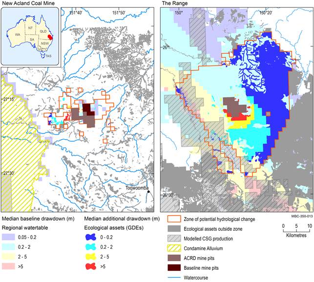
Baseline drawdown is the maximum difference in drawdown (dmax) under the baseline relative to no coal resource development. Additional drawdown is the maximum difference in drawdown (dmax) between the coal resource development pathway (CRDP) and baseline, due to additional coal resource development. The mine pits in the CRDP are the sum of those in the baseline and the additional coal resource development. Areas within modelled open-cut mine pits (Table 4) are not included in this analysis.
ACRD = additional coal resource development, CSG = seam coal gas, GDE = groundwater-dependent ecosystem
Data: Bioregional Assessment Programme (Dataset 2, Dataset 4, Dataset 5, Dataset 6, Dataset 7, Dataset 8)
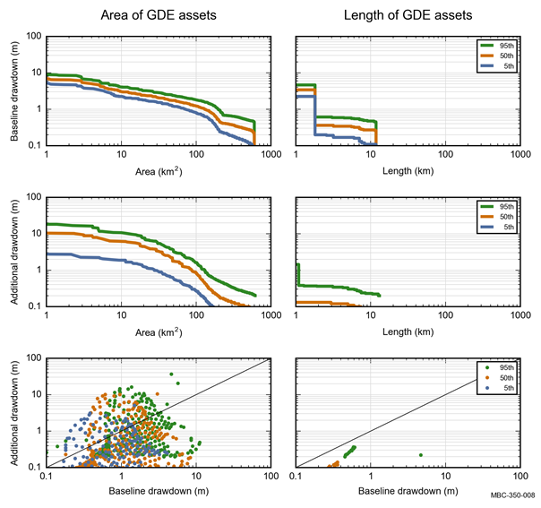
Colours represent the 5th, 50th and 95th percentile. Baseline drawdown is the maximum difference in drawdown (dmax) under the baseline relative to no coal resource development. Additional drawdown is the maximum difference in drawdown (dmax) between the coal resource development pathway (CRDP) and baseline, due to additional coal resource development. Areas within modelled open-cut mine pits (Table 4) are not included in this analysis. GDE = groundwater-dependent ecosystem
Data: Bioregional Assessment Programme (Dataset 3)
Table 26 Number and extent of ecological water-dependent assets in the ‘Vegetation’ subgroup that exceed the 5th, 50th and 95th percentile estimates of baseline drawdown (m) in the zone of potential hydrological change
aNumbers in table are italicised, to distinguish from areas. Numbers within the whole zone are included in this analysis.
bLengths or areas within modelled open-cut mine pits (Table 4) are not included in this analysis.
cExtent could be length or area.
The extent potentially exposed to ≥0.2, ≥2 and ≥5 m baseline drawdown is shown for the 5th, 50th and 95th percentile estimates of the maximum difference in drawdown (dmax) under the baseline relative to no coal resource development. Areas and lengths within modelled open-cut mine pits are not included in this analysis. The zone of potential hydrological change is defined as the area with a greater than 5% chance of exceeding 0.2 m drawdown due to additional coal resource development.
Data: Bioregional Assessment Programme (Dataset 3)
Table 27 Number and extent of ecological water-dependent assets in the ‘Vegetation’ subgroup that exceed the 5th, 50th and 95th percentile estimates of additional drawdown (m) in the zone of potential hydrological change
aNumbers in table are italicised, to distinguish from areas. Numbers within the whole zone are included in this analysis.
bLengths or areas within modelled open-cut mine pits (Table 4) are not included in this analysis.
cExtent could be length or area.
The extent potentially exposed to ≥0.2, ≥2 and ≥5 m additional drawdown is shown for the 5th, 50th and 95th percentile estimates of the maximum difference in drawdown (dmax) between the coal resource development pathway (CRDP) and baseline, due to additional coal resource development. Areas and lengths within modelled open-cut mine pits (Table 4) are not included in this analysis. The zone of potential hydrological change is defined as the area with a greater than 5% chance of exceeding 0.2 m drawdown due to additional coal resource development.
Data: Bioregional Assessment Programme (Dataset 3)
3.5.2.4.2 ‘Habitat (potential species distribution)’ and ‘Riparian vegetation’ classes
The water-dependent asset register for the Maranoa-Balonne-Condamine subregion includes 171 habitat (potential species distribution) assets and 20 riparian vegetation assets (Bioregional Assessment Programme, Dataset 2; Bioregional Assessment Programme, 2017), including:
- 118 threatened ecological communities, species or regional ecosystems, comprising
- 8 threatened ecological communities and 52 species listed under the EPBC Act
- 31 threatened species and 27 endangered regional ecosystems listed under the Nature Conservation Act
- 53 protected reserves, parks and bird habitats, comprising
- 40 reserves and parks listed in the Collaborative Australian Protected Area Database (CAPAD)
- 10 protected reserves, parks or habitats nominated by the community
- 3 bird habitats identified as Important Bird Areas (Birdlife Australia, 2014)
- 20 riparian vegetation assets, comprising
- 20 water-dependent assets identified by the community in the Water Assessment Information Tool database (WAIT) or listed in the Murray–Darling Basin Authority Key Environmental Asset (KEA) datasets.
The asset under consideration is the habitat of the species, community or ecosystem rather than the species, community or ecosystem per se, hence these assets are listed under the ‘Vegetation’ subgroup. Habitats were considered water dependent if there was evidence for a dependency or an association with alluvial and soakage areas, drainage lines, floodplain or riparian vegetation communities, wetlands and/or permanent open water or mound springs. The decision not to include species in the asset register was based on evidence from species profiles and other published material that show that these habitats are almost entirely restricted to grassland, woodland, dry scrub, open forest, heathlands or rainforest vegetation communities or rocky outcrops.
The zone of potential hydrological change includes 41 water-dependent assets in the ‘Habitat (potential species distribution)’ or ‘Riparian vegetation’ classes (Bioregional Assessment Programme, Dataset 3; Bioregional Assessment Programme, 2017). This includes:
- 39 threatened ecological communities, species or regional ecosystems, comprising
- 4 threatened ecological communities and 18 species listed under the EPBC Act
- 11 threatened species and 6 endangered regional ecosystems listed under the Nature Conservation Act
- 2 riparian vegetation assets identified by the community in WAIT that cover 17 km2.
No protected reserves, parks, bird habitats or key environmental assets are in the zone of potential hydrological change.
The extent of habitat areas where the median (50th percentile) estimate of drawdown due to additional coal resource development exceeds 0.2 m in the regional watertable covers 618 km2. Median drawdown for habitat areas is predominantly less than 5 m, with the exception of 49 km2 potentially affected by additional coal resource development in the immediate vicinity of the operational areas, and 43 km2 to the south-west of The Range coal mine potentially affected by baseline coal resource development (Figure 41).
Median drawdown for riparian vegetation is predominantly less than 2 m, including 6 km2 under the baseline and 1 km2 potentially affected by additional coal resource development in the zone of potential hydrological change (Table 26 and Table 27).
The nature of water dependency of the 39 threatened ecological communities, species or regional ecosystems in the zone of potential hydrological change is described in Table 28. The potential distribution of three threatened species – fork-tailed swift (Apus pacificus), great egret (Ardea alba) and red goshawk (Erythrotriorchis radiatus) – covers the entire zone of potential hydrological change.
The potential distribution of a further six threatened species covers large parts of the zone of potential hydrological change, including the star finch (eastern) (Neochmia ruficauda ruficauda) (91%), painted honeyeater (Grantiella picta) (65%), brigalow scaly-foot (Paradelma orientalis) (48%), southern squatter pigeon (Geophaps scripta scripta) (42%), large-eared pied bat (Chalinolobus dwyeri) (35%) and satin flycatcher (Myiagara cyanoleuca) (17%). The potential distribution of the remaining habitat areas covers less than 10% of the zone of potential hydrological change (Table 29 and Table 30).
The potential distribution of the ‘Natural grasslands on basalt and fine-textured alluvial plains of northern New South Wales and southern Queensland Threatened Ecological Community’ covers 9% of the zone of potential hydrological change in the vicinity of New Acland Coal Mine (Figure 40).
Several assessment units are predicted to experience drawdown in excess of 2 m under the baseline and due to additional coal resource development (Figure 41). These assessment units are located in the immediate vicinity of the operational areas and contain parts of these widely distributed habitat areas (Figure 40).
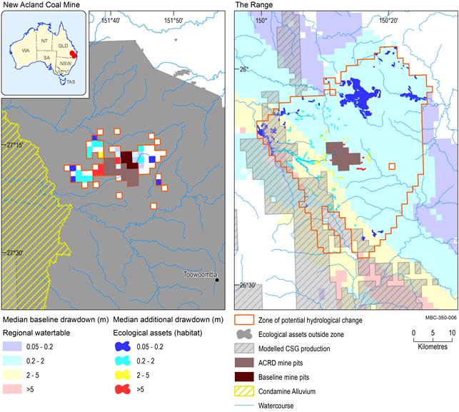
Baseline drawdown is the maximum difference in drawdown (dmax) under the baseline relative to no coal resource development. Additional drawdown is the maximum difference in drawdown (dmax) between the coal resource development pathway (CRDP) and baseline, due to additional coal resource development. The mine pits in the CRDP are the sum of those in the baseline and the additional coal resource development. Areas within modelled open-cut mine pits (Table 4) are not included in this analysis.
ACRD = additional coal resource development, CSG = coal seam gas
Data: Bioregional Assessment Programme (Dataset 2, Dataset 4, Dataset 5, Dataset 6, Dataset 7, Dataset 8)
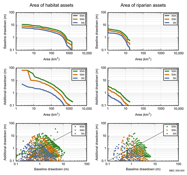
Colours represent the 5th, 50th and 95th percentile. Baseline drawdown is the maximum difference in drawdown (dmax) under the baseline relative to no coal resource development. Additional drawdown is the maximum difference in drawdown (dmax) between the coal resource development pathway (CRDP) and baseline, due to additional coal resource development. Areas within modelled open-cut mine pits (Table 4) are not included in this analysis.
Data: Bioregional Assessment Programme (Dataset 3)
Table 28 ‘Habitat (potential species distribution)’ class: nature of water dependency in the class for those assets listed under the Commonwealth’s Environment Protection and Biodiversity Conservation Act 1999 or Queensland’s Nature Conservation Act 1992 in the zone of potential hydrological change
aPunctuation and typography appear as used in the asset database.
Data: Bioregional Assessment Programme (Dataset 3)
Table 29 ‘Habitat (potential species distribution)’ class: area (km2) of assets listed under the Commonwealth’s Environment Protection and Biodiversity Conservation Act 1999 or Queensland’s Nature Conservation Act 1992 that exceed the 5th, 50th and 95th percentile estimates of baseline drawdown in the zone of potential hydrological change
aPunctuation and typography appear as used in the asset database.
bAreas exclude the modelled open-cut mine pits.
The extent potentially exposed to ≥0.2, ≥2 and ≥5 m baseline drawdown is shown for the 5th, 50th and 95th percentile estimates of the maximum difference in drawdown (dmax) under the baseline relative to no coal resource development. Areas within modelled open-cut mine pits (Table 4) are not included in this analysis. The zone of potential hydrological change is defined as the area with a greater than 5% chance of exceeding 0.2 m drawdown due to additional coal resource development.
Data: Bioregional Assessment Programme (Dataset 3)
Table 30 ‘Habitat (potential species distribution)’ class: area (km2) of assets listed under the Commonwealth’s Environment Protection and Biodiversity Conservation Act 1999 or Queensland’s Nature Conservation Act 1992 that exceed the 5th, 50th and 95th percentile estimates of additional drawdown in the zone of potential hydrological change
aPunctuation and typography appear as used in the asset database.
bAreas exclude the modelled open-cut mine pits.
The extent potentially exposed to ≥0.2, ≥2 and ≥5 m additional drawdown is shown for the 5th, 50th and 95th percentile estimates of the maximum difference in drawdown (dmax) between the coal resource development pathway (CRDP) and baseline, due to additional coal resource development. The zone of potential hydrological change is defined as the area with a greater than 5% chance of exceeding 0.2 m drawdown due to additional coal resource development.
Data: Bioregional Assessment Programme (Dataset 3)
