The groundwater zone of potential hydrological change is defined as the area with a greater than 5% chance of exceeding 0.2 m drawdown in the source aquifer due to additional coal resource development (Figure 13). This 5% chance is determined based on an uncertainty analysis as described in Section 2.6.2.8 of companion product 2.6.2 for the Maranoa-Balonne-Condamine subregion (Janardhanan et al., 2016). It means that 95% of groundwater model runs exceeded this level of drawdown. Groundwater impacts due to coal mines and coal seam gas (CSG) projects are regulated under state legislation and state regulatory and management frameworks. The 0.2 m drawdown threshold adopted in BAs is consistent with the most conservative minimal impact threshold in the NSW Aquifer Interference Policy (DPI, 2012) and Queensland’s Water Act 2000. See also Queensland’s Underground water impact report for the Surat Cumulative Management Area (QWC, 2012).
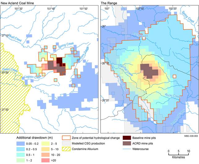
The zone of potential hydrological change is the area with a greater than 5% chance of exceeding 0.2 drawdown due to additional coal resource development in the relevant aquifers. Additional drawdown is the maximum difference in drawdown (dmax) between the coal resource development pathway (CRDP) and baseline, due to additional coal resource development. In a confined aquifer, drawdown relates to a change in water pressure and does not necessarily translate to changes in depth to watertable. The mine pits in the CRDP are the sum of those in the baseline and the additional coal resource development (ACRD).
CSG = coal seam gas
Data: Bioregional Assessment Programme (Dataset 1, Dataset 2, Dataset 3, Dataset 4); Office of Groundwater Impact Assessment (Dataset 5, Dataset 6)
