3.4.4.2.1 Groundwater
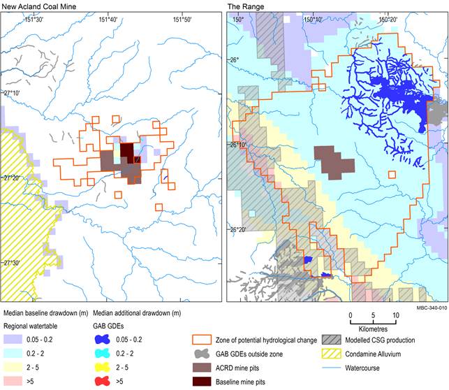
Potentially impacted GAB GDEs cover 76 km2 (which is 4.4% of the landscape group in the assessment extent) of remnant vegetation and 319 km (4.1%) of streams in the zone of potential hydrological change (outside of modelled open-cut mine pits) (Figure 28 and Table 8). Most of the remnant vegetation (75 km2) and watercourses (254 km) that access GAB aquifers in the zone of potential hydrological change are to the north-east of The Range coal mine in an area of Hutton Sandstone aquifer outcrop.
None of the 153 GAB springs in the assessment extent are within 50 km of where there is at least a 5% chance of exceeding 0.2 m drawdown due to additional coal resource development predicted in the source aquifer identified for each spring (Office of Groundwater Impact Assessment, Dataset 5; Bioregional Assessment Programme, Dataset 6).
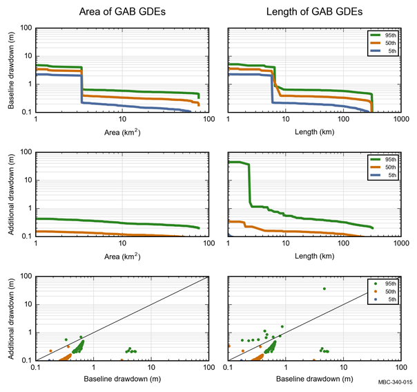
The median (50th percentile) estimate of greater than 0.2 m drawdown due to additional coal resource development is smaller and includes less than 1 km2 of remnant vegetation and 3 km of streams in this landscape group (Table 14). Figure 28 and Figure 29 show that most of the streams classified as ‘GAB GDEs’ in the north-eastern part of the zone of potential hydrological change have a median drawdown due to additional coal resource development of less than 0.2 m. Median baseline drawdown in the zone of potential hydrological change is predominantly less than 2 m, containing 3 km2 of remnant vegetation and 5 km of stream network (Table 13).
Median is the 50th percentile. Baseline drawdown is the maximum difference in drawdown (dmax) under the baseline relative to no coal resource development. Additional drawdown is the maximum difference in drawdown (dmax) between the coal resource development pathway (CRDP) and baseline, due to additional coal resource development. The mine pits in the CRDP are the sum of those in the baseline and the additional coal resource development. Landscape classes within modelled open-cut mine pits are not included in this analysis.
ACRD = additional coal resource development, CSG = coal seam gas, GAB = Great Artesian Basin, GDE = groundwater-dependent ecosystem
Data: Bioregional Assessment Programme (Dataset 1, Dataset 2, Dataset 3, Dataset 4, Dataset 8, Dataset 9)
Baseline drawdown is the maximum difference in drawdown (dmax) under the baseline relative to no coal resource development. Additional drawdown is the maximum difference in drawdown (dmax) between the coal resource development pathway (CRDP) and baseline, due to additional coal resource development. Landscape classes within modelled open-cut pits are not included in this analysis. GAB = Great Artesian Basin, GDE = groundwater-dependent ecosystem
Data: Bioregional Assessment Programme (Dataset 7)
Table 13 ‘GAB GDEs (riverine, springs, floodplain or non-floodplain)’ landscape group: area (km2), stream network length (km) and number of springs (number) that exceed the 5th, 50th and 95th percentile estimates of baseline drawdown in the zone of potential hydrological change
aExtent could be number, length or area and excludes modelled open-cut mine pits.
Baseline drawdown is the maximum difference in drawdown (dmax) under the baseline relative to no coal resource development. Landscape classes within modelled open-cut mine pits are not included in this analysis. Due to rounding, some totals may not correspond with the sum of the separate numbers.
GAB = Great Artesian Basin, GDE = groundwater-dependent ecosystem
Data: Bioregional Assessment Programme (Dataset 7)
Table 14 ‘GAB GDEs (riverine, springs, floodplain or non-floodplain)’ landscape group area (km2), stream network length (km) and number of springs (number) that exceed the 5th, 50th and 95th percentile estimates of drawdown due to additional coal resource development in the zone of potential hydrological change
aExtent could be a number, length or area and excludes modelled open-cut mine pits.
Additional drawdown is the maximum difference in drawdown (dmax) between the coal resource development pathway (CRDP) and baseline, due to additional coal resource development. Landscape classes within modelled open-cut mine pits are not included in this analysis. Due to rounding, some totals may not correspond with the sum of the separate numbers.
GAB = Great Artesian Basin, GDE = groundwater-dependent ecosystem
Data: Bioregional Assessment Programme (Dataset 7)
3.4.4.2.2 Surface water
No surface water numerical modelling was undertaken for the Maranoa-Balonne-Condamine subregion. Some potential hydrological changes may, however, be specified conceptually based on scientific logic as described in Section 3.3.
