The conceptual model of causal pathways describe the logical chain of events ‒ either planned or unplanned ‒ that link coal resource development to potential impacts on water resources and water-dependent assets. These causal pathways provided the logical and transparent foundation for the impact and risk analysis and are described in companion product 2.3 for the Maranoa-Balonne-Condamine subregion (Holland et al., 2016).
A systematic hazard analysis, using the Impact Modes and Effects Analysis method (described in companion submethodology M11 (as listed in Table 1) for hazard analysis (Ford et al., 2016)), was undertaken for the Maranoa-Balonne-Condamine subregion. The hazard analysis identified activities that occur as part of coal resource development that might result in a change in the quality or quantity of surface water or groundwater. Hazards were prioritised according to the likelihood, severity and detectability of potential impacts (Bioregional Assessment Programme, Dataset 1). It is important to ensure that all hazards are addressed by the impact and risk analysis, but this does not mean that all causal pathways need to be assessed in the same way, only that they are all addressed in some way.
The many individual ‘hazards’ themselves were not represented directly in the hydrological models, but instead were grouped into four causal pathway groups, which reflect the main hydrological pathways by which the effects of a hazard can propagate from its origin. These simplified pathways are broadly represented in the BA hydrological models. These causal pathway groups are:
- ‘Subsurface depressurisation and dewatering’
- ‘Subsurface physical flow paths’
- ‘Surface water drainage’
- ‘Operational water management’.
Figure 5, Figure 6 and Table 3 describe the system components and associated hydrological effects of the causal pathways considered to be in scope for open-cut coal mines and CSG operations in the Maranoa-Balonne-Condamine subregion (refer Section 2.3.5 in companion product 2.3 (Holland et al., 2016)). Hydrological effects associated with coal resource development occur in four system components:
- ‘watercourses within and downstream of tenements’ system component
- ‘alluvium and watercourses in aquifer outcrop areas within and downstream of tenements’ system component
- ‘aquifers within tenements’ system component
- ‘aquifers’ system component.
The hydrological models represent causal pathways through their conceptualisations and parameterisations. The outputs from the hydrological models do not identify individual causal pathways but rather integrate the various possible causal pathways into the predicted hydrological response at particular points in space and time.
Not all hydrological effects can be modelled. Some cannot be modelled due to scale or complexity and were addressed qualitatively using the current conceptual understanding and knowledge base. Changes in water quality due to coal resource development activities were considered qualitatively through potential effects on stream salinity (Section 3.3.4). Some identified hazards were deemed to be local in scale and addressed by existing site-based management, whereas some were considered knowledge gaps (e.g. because the location and volume of reinjection of co‑produced water to restore groundwater pressure in a depleted aquifer is unknown). Others were considered of such low likelihood and/or consequence for broader cumulative impacts at the regional scale that they were not included.
While the causal pathway groups are generic, the physical characteristics of a subregion, such as its geological, geophysical and topographic architecture, and related surface water and groundwater networks, will influence the hydrological connectivity across the subregion. The Assessment team’s conceptual understanding of the dominant geological and topographic influences on surface water and groundwater connectivity in the Maranoa-Balonne-Condamine subregion is described in companion product 2.3 (Holland et al., 2016). The cumulative effects of aquifer depressurisation associated with coal resource development in the Maranoa-Balonne-Condamine subregion predicted by the groundwater numerical modelling is described in companion product 2.6.2 (Janardhanan et al., 2016). Hydrological effects that can and cannot, or have not been modelled are indicated in Figure 6.
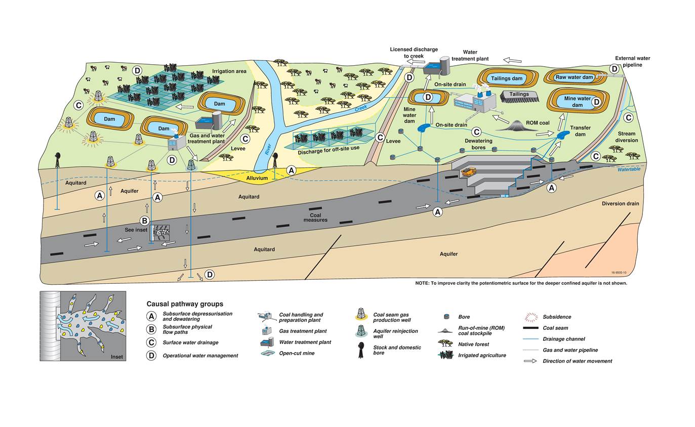
This conceptual diagram is not drawn to scale. The inset schematic shows hydraulic fracturing of a coal seam, where a mixture predominantly composed of water (blue) and sand (yellow), with minor amounts of chemical additives, is injected at high pressure into the well to produce small cracks in the coal (lighter grey zone). This process enhances the permeability of the coal seam, enabling larger volumes of gas and water to be subsequently pumped from the well.
This figure has been optimised for printing on A3 paper (420 mm x 297 mm).
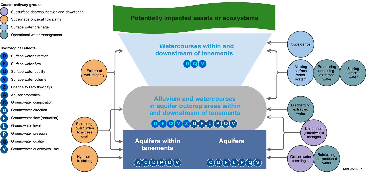
This figure has been optimised for printing on A3 paper (420 mm x 297 mm).
Table 3 Causal pathways in the Maranoa-Balonne-Condamine subregion and their associated hazards, hydrological effects, system components and temporal context
Each causal pathway is listed in a chain of logic from the hazard and associated hydrological effects to system components (as defined in Figure 5) that may contain potentially impacted assets or ecosystems.
Full descriptions of the causal pathways and causal pathway groups are available in companion submethodology M05 (as listed in Table 1) for developing a conceptual model of causal pathways (Henderson et al., 2016).
ashort term = less than 5 years, medium term = 5 to 10 years, long term = 10 to 100 year
bMisspelled in the hazard workshop. Correct terminology is ‘mis-perforation of coal seam’.
Typology and punctuation are consistent with the hazard analysis (Bioregional Assessment Programme, Dataset 1).
Data: Bioregional Assessment Programme (Dataset 1)
