The ‘Non-floodplain or upland riverine (including non-GAB GDEs)’ landscape group includes ecosystems that are dependent on upland streams and wetlands that are not associated with alluvial systems, and non-GAB GDEs that are associated with perched watertables, such as inland sand ridges, and permeable rock types, such as the basalt aquifers of the Main Range Volcanics. ‘Non-GAB springs’ are associated with local flow systems in the basalt aquifers and are disconnected from the underlying GAB aquifers. Upland streams and wetlands are characterised by a highly temporary surface water regime, characterised by surface water pulses following rainfall. Localised groundwater discharge in upland areas at the surface, into wetland systems and streams supports non-floodplain, non-GAB GDE remnant vegetation and aquatic communities.
Inland sand ridges occur outside the most elevated portion of the floodplain or alluvial land zones and are more common in the western part of the assessment extent. Inland sand ridges support Corymbia and Eucalyptus species with varying reliance on perched aquifers within the sandy profile (Holloway et al., 2013).
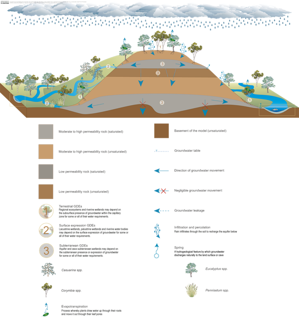
Ecosystems dependent on groundwater held in permeable rocks such as basalts are common in the eastern portion of the assessment extent in the more elevated Main Range Volcanics of the Great Dividing Range. Groundwater is transmitted and stored through fractures, inter-granular spaces or weathered zones and is typically discharged to the surface at contact zones between two rock types (Figure 30) (DSITI, 2015). Associated plant communities tend to be open woodlands, dominated by Eucalyptus spp. on Cenozoic igneous rocks and with shrub and grass (Pennisetum spp.) layers. Small stands of brigalow and semi-evergreen vine thickets are also supported by these permeable landforms with subsurface expression of groundwater. Aquifers in permeable rocks may also support ecosystems within the aquifer itself, which is sometimes indicated by the presence of stygofauna (DEHP, 2015). These non-floodplain, non-GAB GDEs are characterised by localised flow systems that have intermittent/aseasonal hydrological connectivity (Figure 30) (DSITI, 2015).
Non-floodplain, temporary wetlands on low permeability, shrink-swell cracking clays sometimes form gilgai (meaning ‘small waterhole’ wetlands) (DEHP, 2013c). These temporary wetlands are essentially small depressions within the Cenozoic clay deposits that are interspersed with mounds and depressions over relatively small distances (approximately 2 m; Chertkov, 2005). The timing and magnitude of wet and dry phases within these wetlands are determined by localised runoff from rainfall, which means that their dependency on the surface water network at larger scales is likely to be negligible.
GDE = groundwater-dependent ecosystem
Source: DEHP (2015)
The zone of potential hydrological change contains six landscape classes in the ‘Non-floodplain or upland riverine (including non-GAB GDEs)’ landscape group. These are ‘Non-floodplain non-GAB GDE’, ‘Non-floodplain, non-GAB GDE, near-permanent wetland’, ‘Non-floodplain, near-permanent wetland’, ‘Non-floodplain, temporary wetland’, ‘Temporary, upland non-GAB GDE stream’ and ‘Temporary, upland stream’. None of the ‘Non-GAB springs’ that access the aquifers associated with the Main Range Volcanics are contained within the zone of potential hydrological change. The basalt aquifers are represented in layer 1 of the OGIA groundwater model, which is used to define the zone of potential hydrological change for the regional watertable.
The temporary, upland streams intersect temporary or near-permanent non-floodplain wetlands, indicating a reliance of these wetlands on riverine or instream flow patterns. Pulse events dominate temporary, upland riverine systems in this landscape group and inundate standing water bodies including the temporary and near-permanent wetlands. Thus, pulse events improve longitudinal connectivity along the channel or drainage line. Unlike lowland riverine systems, these moderate- to high-flow events recede abruptly after rainfall, resulting in no or limited overbank flows.
Hydrological response variables identified for the ‘Non-floodplain or upland riverine (including non-GAB GDEs)’ landscape group are summarised in Table 15. Groundwater discharge to streams also supports the maintenance of flow regimes to support the channel habitat. The temporary nature of the upland riverine systems in this landscape group mean that changes to the magnitude and duration of high flows and the frequency and variability of flood pulses will affect water availability. Temporary upland streams that are associated with non-GAB aquifers are also potentially affected by drawdown.
Wetlands within the zone of potential hydrological change are dependent on surface water flow regimes, particularly the magnitude and duration of high flows and the frequency and variability of flood pulses. Remnant vegetation classified as ‘Non-floodplain, non-GAB GDE’ is dependent on access to groundwater and so is potentially affected by maximum drawdown in the regional watertable, annual amplitude of drawdown, rate of annual drawdown and change to groundwater quality.
Table 15 Ecological relevance of hydrological changes for landscape classes in the ‘Non-floodplain or upland riverine (including non-GAB GDEs)’ landscape group that are contained within the zone of potential hydrological change
GAB = Great Artesian Basin, GDE = groundwater-dependent ecosystem
