There are many geological maps for the bioregion that range in scale from 1:100,000 to 1:1,000,000.
Geological maps used in the Assessment are:
- South-East Queensland geology (Bioregional Assessment Programme, Dataset 15): this dataset contains 1:100,000 digital map sheets for the entire bioregion in Queensland. This map is used to define the surface geology extent for the three-dimensional geological modelling in Queensland
- Warwick-Tweed Heads 1:250,000 dataset (Brunker et al., 1972): covers the northern part of the bioregion in NSW
- Surface geology map of Australia: 1:1,000,000 geological maps (compiled at a 1:250,000 scale) that cover the entire bioregion (Bioregional Assessment Programme, Dataset 16)
- NSW Coastal Quaternary Geology (1:25,000 and 1:100,000 scales): detailed geological maps of the Quaternary geology in the coastal region of the bioregion in NSW.
- An unreleased GIS dataset of the revised bedrock geology in NSW (Geological Survey of NSW, 2014). One of the challenges in this project is that a change in the stratigraphic classification of the Clarence-Moreton Basin sedimentary sequences has been proposed by Doig and Stanmore (2012) based on the newly available data from CSG exploration wells. This proposed revision has been adopted by the Geological Survey of NSW. A new (preliminary) GIS dataset of the boundaries of the bedrock stratigraphic units in the bioregion in NSW has been developed by the Geological Survey of NSW (Geological Survey of NSW, 2014) and provided for the purpose of the Assessment (Geological Survey of NSW, Dataset 6).
Apart from the larger-scale (1:1,000,000 or 1:2,000,000) geological maps which generally do not show enough differentiation between formations (e.g. between the Gatton Sandstone and the Koukandowie Formation in many areas), there is no single geological map that covers the entire bioregion. As a result, and also to account for the revision of the stratigraphy of the Clarence-Moreton Basin in NSW, a new composite geological map which combines different datasets was developed for the Assessment (Figure 10). To serve the purpose of the three-dimensional geological modelling, this composite geological map needed to be further simplified as only limited complexity can be captured by the three-dimensional geological model due to computational limitations.
To achieve this simplification, stratigraphic units were combined where possible (e.g. different intrusive rocks were combined into a single class) and the alluvial aquifer boundaries were changed to exclude small alluvial tributary systems with widths of less than 200 m.
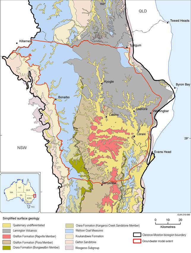
This map adopts the revised stratigraphic classification proposed by Doig and Stanmore (2012).
Data: (i) Surface geology map of Australia 1:1,000,000 (Bioregional Assessment Programme, Dataset 16), (ii) Geological Survey of NSW (Dataset 6), (iii) Geological survey of Queensland (Bioregional Assessment Programme, Dataset 15)
