- Home
- Assessments
- Bioregional Assessment Program
- Galilee subregion

This bioregional assessment helps us understand how coal seam gas and coal mining development could affect water resources and water-dependent assets in the Galilee subregion. It identifies where potential impacts might occur, as well as the areas that are unlikely to be affected. The assessment is being undertaken in collaboration with the Queensland Government, which contributed funding to support this work.
About this subregion
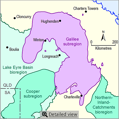
The Galilee subregion is part of the Lake Eyre Basin bioregion and is entirely within Queensland. It extends westwards across the Great Dividing Range and into the Lake Eyre drainage basin. The subregion is sparsely populated, with most people living in towns and localities including Charleville, Barcaldine, Blackall and Hughenden.
The subregion encompasses the headwaters of several major waterways including the Cooper Creek and the Diamantina, Belyando, Cape, Thomson, Barcoo, Flinders, Bulloo, and Warrego rivers. In addition to the river systems, the subregion has numerous wetlands, springs, waterholes and lakes, including the nationally important lakes Buchanan and Galilee. Some of these are home to diverse and unique plants and animals, many of which are listed as rare or threatened under Queensland and Commonwealth legislation.
Native vegetation consists largely of grasslands in the west and open eucalyptus woodlands in the east. Cattle and sheep grazing on native pasture is the main land use and groundwater is of great importance.
Coal mining and coal seam gas operations
The geological Galilee Basin contains extensive resources of black coal. Although no commercial coal mines or coal seam gas production facilities are currently established in the subregion, six new large coal mines are scheduled to start production by 2020. Five of these coal mines will involve both open-cut and underground operations. Most of these proposed coal mines are well advanced in securing all necessary development approvals.
The development of a coal seam gas industry in the Galilee Basin is significantly less advanced than for coal with developments still being at resource appraisal stage.
About the bioregional assessment
The bioregional assessment for the Galilee subregion involves compiling background information, a water-dependent asset register and a data register. The assessment will provide the first regional-scale information about the cumulative impacts of coal resource development on water resources and water-dependent assets in the Galilee subregion. An outcome synthesis will be produced for the Galilee subregion.
Supporting knowledge projects
Several related projects investigated the surface and groundwater resources in coal basins within the Lake Eyre Basin, including.
- Lake Eyre Basin Rivers Monitoring
- Lake Eyre Basin Springs Assessment
- Numerical groundwater model for the Galilee Basin
Factsheet
Published products
- Area: 248,000 square kilometres
- Population: less than 20,000
- Climate: generally hot and dry throughout
- Annual rainfall: 300 to 700 millimetres
- Bioregional Assessment Program
- Lake Eyre Basin bioregion
- Northern Inland Catchments bioregion
- Clarence-Moreton bioregion
- Northern Sydney Basin bioregion
- Sydney Basin bioregion
- Gippsland Basin bioregion
- Indigenous assets
- Methods
- Bioregional assessment methodology
- Submethodologies
- Compiling water-dependent assets
- Assigning receptors to water-dependent assets
- Developing a coal resource development pathway
- Developing the conceptual model of causal pathways
- Surface water modelling
- Groundwater modelling
- Receptor impact modelling
- Propagating uncertainty through models
- Impacts and risks
- Systematic analysis of water-related hazards associated with coal resource development
- Assessment components
- Metadata and datasets
- Geological and Bioregional Assessment Program

