- Home
- Assessments
- Bioregional Assessment Program
- Sydney Basin bioregion

This bioregional assessment identifies current and future coal and coal seam gas resources and developments, as well as water-dependent assets in the Sydney Basin bioregion.
At a glance
The Sydney Basin provides water for over five million people and coal for local and international markets. There is also coal seam gas extraction at Camden.
About the bioregion
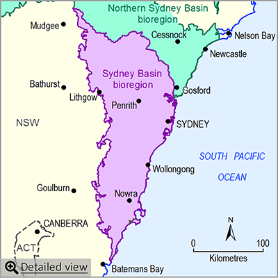
The Sydney Basin bioregion adjoins the Northern Sydney Basin bioregion, and extends from Capertee in the north to Durras on the south coast of New South Wales. Major rivers in the Sydney Basin bioregion include the Hawkesbury River and its main tributary the Nepean River, as well as the Georges and the Shoalhaven rivers.
The Sydney Basin bioregion includes Australia’s largest city, Sydney, as well as the cities and towns of Wollongong, Bowral, Moss Vale, Nowra and Lithgow. It also includes significant parts of the Blue Mountains, Wollemi and Moreton national parks.
Factsheet
Published products
- Area: about 25,000 square kilometres
- Population: about 5 million
- Climate: temperate
- Annual rainfall: ranges from about 800 millimetres (inland) to about 1300 millimetres (coast).
- Bioregional Assessment Program
- Lake Eyre Basin bioregion
- Northern Inland Catchments bioregion
- Clarence-Moreton bioregion
- Northern Sydney Basin bioregion
- Sydney Basin bioregion
- Gippsland Basin bioregion
- Indigenous assets
- Methods
- Bioregional assessment methodology
- Submethodologies
- Compiling water-dependent assets
- Assigning receptors to water-dependent assets
- Developing a coal resource development pathway
- Developing the conceptual model of causal pathways
- Surface water modelling
- Groundwater modelling
- Receptor impact modelling
- Propagating uncertainty through models
- Impacts and risks
- Systematic analysis of water-related hazards associated with coal resource development
- Assessment components
- Metadata and datasets
- Geological and Bioregional Assessment Program

