- Home
- Assessments
- Bioregional Assessment Program
- Namoi subregion

This bioregional assessment helps us understand how coal seam gas and coal mining development could affect water resources and water-dependent assets in the Namoi subregion, which is part of the Northern Inland Catchments bioregion. It identifies where potential impacts could occur, as well as the areas that are unlikely to be affected.
About the subregion
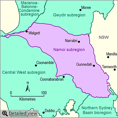
The Namoi subregion is located within the Murray–Darling Basin in central New South Wales. The subregion lies within the Namoi river basin, which includes the Namoi, Peel and Manilla rivers. However, the subregion being assessed is smaller than the Namoi river basin because the eastern part of the river basin does not overlie a coal-bearing geological basin. The largest towns in the subregion are Gunnedah, Narrabri and Walgett.
The main surface water resource of the Namoi subregion is the Namoi River. There are three large dams that supply water to the subregion, of which Keepit Dam is the main water storage. More than half of the water released from Keepit Dam and river inflow may be extracted for use for agriculture, towns and households. Of this, the great majority is used for agricultural irrigation. The landscape has been considerably altered since European settlement for agriculture. Significant volumes of groundwater are also used for agriculture (cropping).
Across the subregion there are a number of water-dependent ecological communities, and plant and animal species that are listed as threatened under either Commonwealth or New South Wales legislation. The subregion also contains Lake Goran, a wetland of national importance, and sites of international importance for bird conservation.
Coal mining and coal seam gas operations
The subregion is underlain by rocks of different ages that belong to the Gunnedah and Surat geological basins, both major coal-bearing basins in eastern Australia. Current coal and coal seam gas development and exploration which might potentially impact on water and water-dependent assets are mainly located in the central and eastern parts of the subregion. There are six coal mines currently operating in the subregion. The Watermark Coal Project was conditionally approved in July 2015, but further steps are required before mining can start.
There is currently no coal seam gas production for commercial purposes in the Namoi subregion. However, potential coal seam gas developments in the subregion are concentrated around areas of current coal mining in the central part of the subregion. While there were six coal seam gas developments in various stages of exploration, pre-development and pilot testing, only the Narrabri Gas Project development is currently under consideration.
About the bioregional assessment
The bioregional assessment for the Namoi subregion will provide new scientific information about the potential impacts of coal and coal seam gas development in the Namoi subregion. This includes the potential impacts on water in the central and eastern parts of the subregion. The assessment will also examine the cumulative impacts for surface water and groundwater across the Namoi river basin. An outcome synthesis will be produced for the Namoi subregion.
Factsheet
Published products
- Area: about 29,300 square kilometres
- Population: about 27,000
- Climate: varies from temperate to sub-tropical
- Annual rainfall: varies from 495 millimetres (west) to 1100 millimetres (south and east)
- Bioregional Assessment Program
- Lake Eyre Basin bioregion
- Northern Inland Catchments bioregion
- Clarence-Moreton bioregion
- Northern Sydney Basin bioregion
- Sydney Basin bioregion
- Gippsland Basin bioregion
- Indigenous assets
- Methods
- Bioregional assessment methodology
- Submethodologies
- Compiling water-dependent assets
- Assigning receptors to water-dependent assets
- Developing a coal resource development pathway
- Developing the conceptual model of causal pathways
- Surface water modelling
- Groundwater modelling
- Receptor impact modelling
- Propagating uncertainty through models
- Impacts and risks
- Systematic analysis of water-related hazards associated with coal resource development
- Assessment components
- Metadata and datasets
- Geological and Bioregional Assessment Program

