- Home
- Assessments
- Bioregional Assessment Program
- Gippsland Basin bioregion

This bioregional assessment helps us understand how coal seam gas and coal mining development could affect water resources and water-dependent assets in the Gippsland Basin bioregion. The Australian Government is working in partnership with the Victorian Government on this bioregional assessment, to ensure that regional expertise and the most up-to-date data are accessed.
About the bioregion
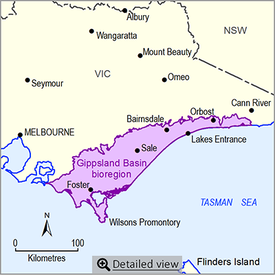
The Gippsland Basin bioregion is in south-eastern Victoria and includes the area between the foothills of the Great Dividing Range to the north, and the Bass Strait coast to the south, Warragul to the west, and Cann River to the east. The offshore part of the Gippsland Basin is not included in the bioregion. Key rivers include the Latrobe River, Thomson River, Macalister River, Mitchell River and Tambo River. All key rivers drain seaward, many passing through nationally and internationally significant wetlands, such as Gippsland Lakes and Corner Inlet.
The landscape is mostly agricultural, but land is also used for forestry and mining. There are four major water storage locations in the bioregion that supply water to major cities and towns, including some outside the bioregion. Groundwater is provided for agriculture, urban and industrial uses, and power station cooling. The bioregion is home to a number of ecological communities, and plant and animal species which are listed as threatened, endangered or critically endangered under Commonwealth legislation.
Coal mining and coal seam gas operations
This bioregion is underlain by rocks of the geological Gippsland Basin, some of which contain significant resources of brown coal (Latrobe Valley Group coal measures). The Gippsland Basin hosts some of the largest brown coal deposits in the world. This coal is mined and supplied to power stations to generate electricity, producing most of Victoria’s electricity needs. There are three coal mines currently operating (Yallourn, Hazelwood and Loy Yang).
About the bioregional assessment
The assessment involves compiling background information, a water-dependent asset register, a data register and the development of a groundwater model and associated reporting.
Gippsland Basin water modelling products
This page provides links to Gippsland Basin bioregion water modelling products, delivered by the Victorian Government as part of the Bioregional Assessment Program.
Gippsland Basin supporting knowledge projects
The Victorian Government delivered four projects to improve knowledge of water-dependent environmental assets in the Gippsland Basin bioregion. Regional organisations were involved in some of these projects.
Factsheet
- Area: 14,636 square kilometres
- Population: more than 200,000
- Climate: temperate
- Annual rainfall: 835 millimetres.
- Bioregional Assessment Program
- Lake Eyre Basin bioregion
- Northern Inland Catchments bioregion
- Clarence-Moreton bioregion
- Northern Sydney Basin bioregion
- Sydney Basin bioregion
- Gippsland Basin bioregion
- Indigenous assets
- Methods
- Bioregional assessment methodology
- Submethodologies
- Compiling water-dependent assets
- Assigning receptors to water-dependent assets
- Developing a coal resource development pathway
- Developing the conceptual model of causal pathways
- Surface water modelling
- Groundwater modelling
- Receptor impact modelling
- Propagating uncertainty through models
- Impacts and risks
- Systematic analysis of water-related hazards associated with coal resource development
- Assessment components
- Metadata and datasets
- Geological and Bioregional Assessment Program

