Galilee assessment at a glance

This bioregional assessment considered the potential cumulative impacts on water and water-dependent assets due to future coal resource development in the Galilee subregion of the Lake Eyre Basin bioregion in central Queensland (Figure 1). Seven of the 17 additional coal resource developments identified (Box 1) had sufficient available information to be modelled (Table 1). This assessment is a regional overview of potential impacts on, and risks to, water-dependent ecological, economic and sociocultural assets, identifying where potential changes in water resources and ecosystems may occur due to the seven modelled coal mines, and ruling out areas where impacts are very unlikely (less than 5% chance). Governments, industry and the community can then focus on the areas that are potentially impacted and apply local-scale data and modelling when making regulatory, water management and planning decisions.
Headline finding: Cumulative hydrological changes in the Belyando river basin are very likely (greater than 95% chance), and extend farther than previously predicted from impact assessments of individual mines.
Groundwater: Drawdown in the near-surface aquifer due to modelled additional coal resource development occurs in two areas near clusters of coal mines in the east, with an area of 2820 km2 very likely to experience greater than 0.2 m drawdown. Major aquifers of the geological Eromanga Basin (part of the Great Artesian Basin) are not expected to be impacted. See Groundwater.
Surface water: Modelled additional coal resource development could impact 6285 km of streams (with at least a 5% chance). Of these, most are temporary streams. See Surface water.
Ecosystem impacts: In the zone of potential hydrological change (Figure 1), 8% of groundwater-dependent streams are at some level of risk of ecological and hydrological changes, and 188 springs have a source aquifer with at least a 5% chance of greater than 0.2 m drawdown due to modelled additional coal resource development. See What are the potential impacts of additional coal resource development on ecosystems?
Asset impacts: Of 241 potentially impacted ecological assets, 148 are relatively ‘more at risk of hydrological changes’. In addition, one surface water right, five groundwater economic assets, and four heritage or Indigenous sites are potentially impacted. See What are the potential impacts of additional coal resource development on water-dependent assets?
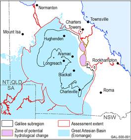
Figure 1 The zone of potential hydrological change
The zone defines the area in the Galilee subregion outside of which impacts are ruled out (see Box 5 for details). The assessment of potential impacts from seven modelled mines was therefore focused within this zone, which combines: (i) the area with at least a 5% chance of exceeding 0.2 m drawdown in the near-surface aquifer due to additional coal resource development, and (ii) the area with at least a 5% chance of exceeding thresholds in specified surface water characteristics due to additional coal resource development.
Data: Bioregional Assessment Programme (Dataset 1, Dataset 2)
