- Home
- Assessments
- Bioregional Assessment Program
- Gloucester subregion
- 2.6.2 Groundwater numerical modelling for the Gloucester subregion
- 2.6.2.2 Review of existing models
Summary
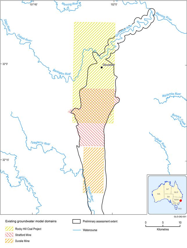
Three existing groundwater models have been identified that cover various parts of the Gloucester preliminary assessment extent (PAE). They are the Duralie Coal Mine model (developed using Groundwater Vistas software), the Stratford Mining Complex model (developed using Groundwater Vistas software) and the Rocky Hill Coal Project model (developed using the MODHMS modelling package). The Duralie Coal Mine model covers the south part of the Gloucester PAE, while the other two models cover the north parts of the Gloucester PAE. All three models were aimed at quantifying the impact of open-cut coal mines on groundwater systems, which also included a few water supply bores that are currently in use, and groundwater levels in alluvial aquifers.
As part of planning approval for the proposed coal seam gas (CSG) project in the Gloucester Basin, AGL Energy Limited (AGL) is developing a local-scale (cross-sectional model using FEFLOW), as well as a regional-scale, groundwater (using MODFLOW) numerical model (AGL Energy Limited, 2014). As these AGL models were still in development at the time of drafting this product, they were not included for review.
All three models are considered not suitable for direct usage in the bioregional assessment (BA) for the Gloucester subregion, mainly because their spatial extent is too limited to simulate the cumulative hydrological change due to the existing and proposed coal resource development.
This review focuses on both local and regional-scale groundwater models developed to simulate the groundwater impacts of coal seam gas (CSG) and coal mining development in the Gloucester subregion. The main goal of the review is to evaluate if any of the existing models can be used in their current form for the purpose of the bioregional assessment (BA) numerical modelling or if they can be modified to suit this purpose. The main criterion is if the spatial extent of the existing models, both horizontally and vertically, covers the preliminary assessment extent (PAE) or at least the entire geological Gloucester Basin.
A secondary aim of the review is to provide an overview of the different conceptualisations and parameterisations of the groundwater system. This information, where suitable, will be used in the BA numerical modelling. In addition to that, the hydrological change predicted by these models will provide a frame of reference for comparison of the model results of the BA modelling.
Three local-scale groundwater flow models have been developed to support the environmental impact statements of the existing (Duralie Coal Mine and Stratford Mining Complex) and proposed coal resource (Rocky Hill Coal Project) developments. They are described in the following sections and Figure 7 shows the model domains of these models. From this map it becomes apparent that none of the existing models covers the entire PAE or geological basin. These models are therefore not suited for the numerical modelling in the Bioregional Assessment Programme.
Figure 7 Model domains of existing groundwater models for the Gloucester subregion
Data: Bioregional Assessment Programme (Dataset 1)
As part of planning approval for the proposed CSG project in the Gloucester Basin, AGL Energy Limited (AGL) is developing a local-scale (cross-sectional model using FEFLOW), as well as a regional-scale, groundwater (using MODFLOW) numerical model (AGL Energy Limited, 2014). As these AGL models were still in development at the time of drafting this product, they were not included for review.

Product Finalisation date
- 2.6.2.1 Methods
- 2.6.2.2 Review of existing models
- 2.6.2.3 Model development
- 2.6.2.4 Boundary and initial conditions
- 2.6.2.5 Implementation of coal resource development pathway
- 2.6.2.6 Parameterisation
- 2.6.2.7 Observations and predictions
- 2.6.2.8 Uncertainty analysis
- 2.6.2.9 Limitations and conclusions
- Citation
- Acknowledgements
- Currency of scientific results
- Contributors to the Technical Programme
- About this technical product

