2.6.2.7.1.1 Groundwater level
The HYDMEAS database (NSW Office of Water, Dataset 1) contains the observations of the regional groundwater monitoring network. Groundwater level measurements from 583 monitoring sites across the Hunter subregion (see Figure 19 in Section 2.1.3 in companion product 2.1-2.2 for the Hunter subregion (Herron et al., 2018)) were obtained. Of these, only 64 monitoring sites have surveyed spatial coordinates (easting, northing and elevation) and have been retained in the observation data set used to constrain the model parameters (Figure 22). These 64 sites have 431 groundwater level measurements, which span January 1983 to December 2012 and have between 1 and 27 observations in this period. It can be seen in Figure 22 that relatively few of these sites are close to the subregion’s coal mining areas.
Local monitoring information, including monitoring data from mining companies, is not included in the analysis to avoid biasing the regional objective function with measurements predominantly affected by local hydrogeological conditions and stresses that are not captured in the regional model. Mining companies install monitoring wells in the vicinity of the mine sites to capture information about local hydrogeological conditions, surface water features or local lenses of more-permeable or less-permeable strata. Within a site-scale groundwater model, these local features can be represented with sufficient spatial detail and the historical stresses with sufficient accuracy for the groundwater-level observations to be used to infer local parameter values or constrain local predictions. In a regional-scale model, the representation of local features and stresses cannot be done at a resolution sufficient to match the information from local-scale observations. Regional-scale parameters will compensate for the missing spatial detail and the accuracy of the imposed historical stresses. As shown by Doherty and Welter (2010) and White et al. (2014), this can lead to a bias in the inferred parameter values, and in turn to biased predictions. Local information can be used in a regional context, if the tolerance of model-to-measurement misfit is increased to account for the missing local detail. This means in the vicinity of mines where, due to the historical pumping rates, hydraulic gradients are expected to be high, large discrepancies between modelled and observed groundwater levels should be expected and tolerated. Effectively, this reduces the information content of the local observations. Establishing an appropriate weighting or tolerance for local observations is site-specific and subjective. It requires an in-depth analysis of the accuracy of the local monitoring network as well as an estimation of the uncertainty in the historical pumping rates.
In order to limit the propensity of biasing regional parameter values through the incorporation of local-scale observations and inherently subjective weighting of these observations, local-scale information from mine groundwater monitoring networks is not used.
Section 2.6.2.8.1 provides the details of how these groundwater level observations are integrated into the objective function to constrain the groundwater model.
ACRD = additional coal resource development
CRDP = baseline + ACRD
Data: NSW Office of Water (Dataset 1)
2.6.2.7.1.2 Streamflow
The groundwater model was not designed to simulate total streamflow in the river system within its model domain, but rather to generate estimates of the surface water – groundwater flux (i.e. change in baseflow) at points along a prescribed stream network due to coal resource development. Constraining these fluxes requires regional estimates of the surface water – groundwater flux, which, as discussed in Section 2.1.5 in companion product 2.1-2.2 for the Hunter subregion (Herron et al., 2018), are not easy to determine.
As an alternative, long-term observed streamflow hydrographs have been used as proxy to constrain estimates of surface water – groundwater flux by the groundwater model. Parameter combinations that result in long-term historical surface water – groundwater fluxes in excess of the 70th percentile of total historical surface water flow were deemed unacceptable. Parameter combinations that result in long-term historical surface water – groundwater fluxes that are more negative than the negative of the 20th percentile of total historical surface water flow (i.e. streamflow losses greater than the 20th percentile of total streamflow) were also deemed unacceptable. The upper constraint is considered conservative as the regional estimate of baseflow contribution to the Hunter River system is between 22% and 66% of total streamflow (see Table 3 in Section 2.3.2.4 in companion product 2.3 for the Hunter subregion (Dawes et al., 2018)). The lower constraint is likewise conservative as it allows for locally losing conditions, while it excludes parameter combinations that give rise to regional losing river conditions.
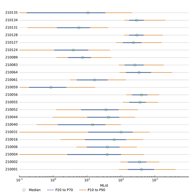
Figure 23 shows the 10th, 20th, 50th, 70th and 90th percentiles of observed streamflow at selected gauge locations in the model domain used to constrain the groundwater model (see Figure 18). Section 2.6.2.8.1 provides more detail on how these streamflow observations are integrated in the objective function to constrain the groundwater model.
Figure 23 Percentiles of total flow at selected gauges in the model domain
Refer to Figure 32 in companion product 2.1-2.2 (Herron et al., 2018) for location of gauges.
Data: Bioregional Assessment Programme (Dataset 2)

Product Finalisation date
- 2.6.2.1 Methods
- 2.6.2.2 Review of existing models
- 2.6.2.3 Model development
- 2.6.2.4 Boundary and initial conditions
- 2.6.2.5 Implementation of the coal resource development pathway
- 2.6.2.6 Parameterisation
- 2.6.2.7 Observations and predictions
- 2.6.2.8 Uncertainty analysis
- 2.6.2.9 Limitations and conclusions
- Citation
- Acknowledgements
- Currency of scientific results
- Contributors to the Technical Programme
- About this technical product


