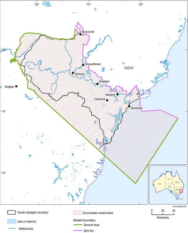
The groundwater model’s boundary conditions are specified in this section.
The model is a three-dimensional model with vertical sides. Its base is defined by the P900 horizon in the geological model of the Hunter subregion (see Section 2.1.2 of companion product 2.1-2.2 for the Hunter subregion (Herron et al., 2018)) (Bioregional Assessment Programme, Dataset 1). Its top is defined by the land topography (Geoscience Australia, Dataset 2) and the bathymetry of the ocean floor (Geoscience Australia, Dataset 3), which have been combined into the Hunter subregion topographic surface for groundwater modelling (Bioregional Assessment Programme, Dataset 4).
The model’s outer boundary was chosen to coincide with the outer boundary of the subregion on its north-eastern side. Here the subregion boundary is defined by the northern extent of the geological Sydney Basin and a small part of the much smaller Werrie Basin around Murrurundi. Lying along the Hunter-Mooki Thrust Fault, and being the boundary of the Sydney Basin, this portion of the model’s lateral boundary is assumed to be a no-flow boundary – that is, not hydrologically connected to the Hunter subregion (shown in Figure 12 by the pink line).
The groundwater modelling domain was extended approximately 100 km from the coastline into the ocean to approximately align with the edge of the Sydney Basin, and approximately 40 km west and south-west of the surface water catchment boundaries which separate the Hunter subregion from the Northern Inland Catchments and Sydney Basin bioregions (see Figure 4 in companion product 1.1 for the Hunter subregion (McVicar et al., 2015)). These extensions were chosen to minimise boundary effects at the ocean–land interface and along the west and south-west boundaries where there are no geological constraints on the groundwater systems, which would restrict the movement of water across this boundary. The areas of extension are evident in Figure 12.
Data: Bioregional Assessment Programme (Dataset 5)
The boundary conditions placed on the model’s outer boundaries are:
- Base. The base of the three-dimensional model is assumed to be impermeable and is defined as a no-flow boundary.
- Top boundary. Conditions at the land surface are driven by dynamic hydrological processes: rainfall recharge, evapotranspiration, and seepage to and from rivers. Details of these fluxes are provided in the following sections. The ocean floor has general-head boundary conditions.
- Vertical sides. The boundaries drawn with a green line in Figure 12 are represented by general-head boundary conditions; the Sydney Basin and Werrie Basin geological boundaries (pink line) are assumed to be impermeable to groundwater and represented by no-flow boundary conditions.
A general-head boundary condition means that fluxes across the boundary are dynamic. The flux (measured in ML/year/m2) at a point (x,y,z) at time (t) is a function of conductance C and the hydraulic gradient, corresponding to the difference in groundwater level h(x,y,z,t) and a reference groundwater level h0(x,y,z):
|
|
(1) |
A uniform conductance C = 10-5 ML/year/m3 is applied over the entire model. The reference groundwater level for the ocean floor is the ocean depth at that point. To obtain the reference groundwater levels on the vertical sides, the groundwater model is first run to steady state using zero-flux boundary conditions, and the reference groundwater levels are set equal to those steady-state heads for the dynamic model runs.

Product Finalisation date
- 2.6.2.1 Methods
- 2.6.2.2 Review of existing models
- 2.6.2.3 Model development
- 2.6.2.4 Boundary and initial conditions
- 2.6.2.5 Implementation of the coal resource development pathway
- 2.6.2.6 Parameterisation
- 2.6.2.7 Observations and predictions
- 2.6.2.8 Uncertainty analysis
- 2.6.2.9 Limitations and conclusions
- Citation
- Acknowledgements
- Currency of scientific results
- Contributors to the Technical Programme
- About this technical product

