In order to model the removal of groundwater that seeps into mine workings, water is extracted from the model at all points within the polygon superimposed upon its seam disc. The rate of extraction is prescribed. This is in contrast to many groundwater models which are constructed to provide flow rate predictions. In that type of groundwater model, general-head boundary conditions are typically applied to the goaf area (void and broken rock left behind after coal extraction) of an underground mine, and the conductance is calibrated to match historical flow rates. For the Hunter subregion groundwater model, flow rates were obtained for: (i) years prior to 2015, from the reported values of mine water make in end-of-year mine reports, end-of-panel reports and environmental impact statements; and (ii) for years beyond 2015, from modelled estimates of mine water make found in environmental impact statements. A linear interpolation is used to estimate flow rates between the data points.
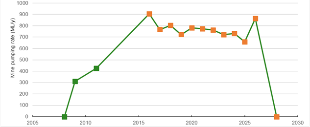
Figure 19 shows an example of rates of water extraction over the life of the Mount Arthur open-cut mine, based on actual and modelled rates. The full set of flow rate time series generated for baseline and CRDP mines is provided in Section 2.1.6 of companion product 2.1-2.2 for the Hunter subregion (Herron et al., 2018).
Figure 19 Time series of groundwater extraction for Mount Arthur open-cut mine
Green points indicate reported values, while orange points indicate future predictions.
Data: Bioregional Assessment Programme (Dataset 3)
Groundwater is extracted uniformly over the entire area defined by the polygon, even though in reality for longwall mines most water will seep out at the face and the panel perimeters. Specifically, if mine water extraction is F (ML/year) and A is the area (m2) of the mine footprint, water is extracted at a uniform rate of F/A ML/year/m2 over the entire footprint. This means longwall chainages (rates of extraction) and progressive pit excavation are not considered. However, to ensure numerical stability of the model, water extraction for a polygon is set to zero if the water head is below –100 m at the level of the seam disc. Negative 100 m was chosen because it is extremely rare to encounter such low heads since it requires a confluence of factors (for example, low hydraulic conductivity and porosity with high pumping rates), but yet it still allows the numerical solver to converge.
The void remaining after mining coal underground is not represented as a ‘hole’ in the model. Such holes are common in models coupled with geomechanics, and in models where very local-scale effects are being studied, such as assessing how much water is produced from the roof, floor and chain pillars. In the Hunter groundwater model, water is simply extracted from the polygons, as described above.
The rates of water extraction are varied in the uncertainty analysis (see Section 2.6.2.8). This is important since the reported historical flow rates are subject to errors, while future flow rates are necessarily predictions, informed by mine-scale groundwater modelling and assumptions about the hydrogeology and development of the mine, and are also uncertain.

Product Finalisation date
- 2.6.2.1 Methods
- 2.6.2.2 Review of existing models
- 2.6.2.3 Model development
- 2.6.2.4 Boundary and initial conditions
- 2.6.2.5 Implementation of the coal resource development pathway
- 2.6.2.6 Parameterisation
- 2.6.2.7 Observations and predictions
- 2.6.2.8 Uncertainty analysis
- 2.6.2.9 Limitations and conclusions
- Citation
- Acknowledgements
- Currency of scientific results
- Contributors to the Technical Programme
- About this technical product

