- Home
- Assessments
- Bioregional Assessment Program
- Namoi subregion
- 5 Outcome synthesis for the Namoi subregion
Namoi assessment at a glance

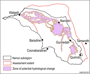
This bioregional assessment considered the potential cumulative impacts on water and water-dependent assets due to ten future additional coal resource developments in the Namoi subregion of NSW (Figure 1). Eight of these ten coal resource developments have sufficient information to be modelled; potential impacts from non-modelled mines are inferred from their location. The assessment is a regional overview of potential impacts on, and risks to, water-dependent ecological, economic and sociocultural assetsecosystems may occur, ruling out areas where impacts are very unlikely (less than 5% chance). Governments, industry and the community can then focus on the areas that are potentially impacted and apply local-scale modelling when making regulatory, water management and planning decisions.
Headline finding: Results from regional-scale hydrological modelling indicate potential risks to 1415 km2 of ecosystems, 1892 km of streams, 2 springs and 724 water-dependent assets. More detailed local information is required to determine the level of risk and potential impacts, including quantifying potential hydrological changes in an additional 3629 km of streams within the zone that could not be modelled.
Groundwater: It is very unlikely (less than 5% chance) that more than 2299 km2 will experience drawdown in the regional watertable of greater than 0.2 m due to additional coal resource development. Of this, 287 km2 is in the alluvium. Modelling shows 0.01% of the lower Namoi alluvium, 8% of the upper Namoi allivium, and none of the main aquifers of the Great Artesian Basin could experience impacts. See Groundwater.
Surface water: Regional-scale modelling indicates that changes in the streamflow of the Namoi River are minimal. However, Back, Merrygowen and Bollol creeks are very likely (greater than 95% chance) to experience changes in their streamflow, particularly in the number of zero-flow days. See Surface water.
Ecosystem impacts: Of the ecosystems in the subregion, floodplains or lowland riverine ecosystems near Maules, Back and Bollol creeks are most likely to experience impacts resulting from changes in hydrology. See What are the potential impacts of additional coal resource development on ecosystems?
Asset impacts: 161 ecological assets are found in areas that are ‘more at risk of hydrological changes’ (Box 10). In the zone of potential hydrological change, risk could not be quantified for 10 unique ecological assets due to data limitations. See What are the potential impacts of additional coal resource development on water-dependent assets?
Figure 1 The zone of potential hydrological change
The pink zone (defined further in Box 4) defines the area in the Namoi subregion, outside of which impacts are ruled out. The assessment of potential impacts therefore focused inside this zone, which combines: (i) the area with at least a 5% chance of exceeding 0.2 m drawdown due to additional coal resource development, and (ii) the area with at least a 5% chance of exceeding thresholds in specified surface water changes that arise due to additional coal resource development.
Data: Bioregional Assessment Programme (Dataset 1)

- Executive summary
- Explore this assessment
- About the subregion
- How could coal resource development result in hydrological changes?
- What are the potential hydrological changes?
- What are the potential impacts of additional coal resource development on ecosystems?
- What are the potential impacts of additional coal resource development on water-dependent assets?
- How to use this assessment
- Building on this assessment
- References and further reading
- Datasets
- Contributors to the Technical Programme
- Acknowledgements
- Citation

