Breadcrumb
The groundwater monitoring networks in the vicinity of the Arckaringa subregion (Figure 28) include:
- The Great Artesian Basin Network that is used to monitor pressure within the artesian and water levels within the non-artesian parts of the GAB. The network in SA is monitored by the South Australian Government Department of Environment, Water and Natural Resources (DEWNR).
- The Marla Monitoring Network, which is used to monitor yield, flow, accumulated flow and water level with data loggers are located in the vicinity of Marla.
- The OZ Minerals Prominent Hill Mining operation monitors water quality, groundwater chemistry and water levels in the vicinity of their wellfield, located approximately 140 southeast of Coober Pedy.
- The IMX Cairn Hill mining operation and the Arrium Mining Peculiar Knob tenement area, located approximately 50 and 60 kms southeast of Coober Pedy respectively, both have associated groundwater monitoring networks within areas that partially overlap. Water levels and water quality are monitored using these networks.
Additionally, a number of different spring groups in the vicinity of the Olympic Dam mining operations are monitored by BHP-Billiton (Sibenaler, 2010). Groundwater monitoring networks associated with the Olympic Dam mining operation are largely located to the east and southeast of the Arckaringa subregion.
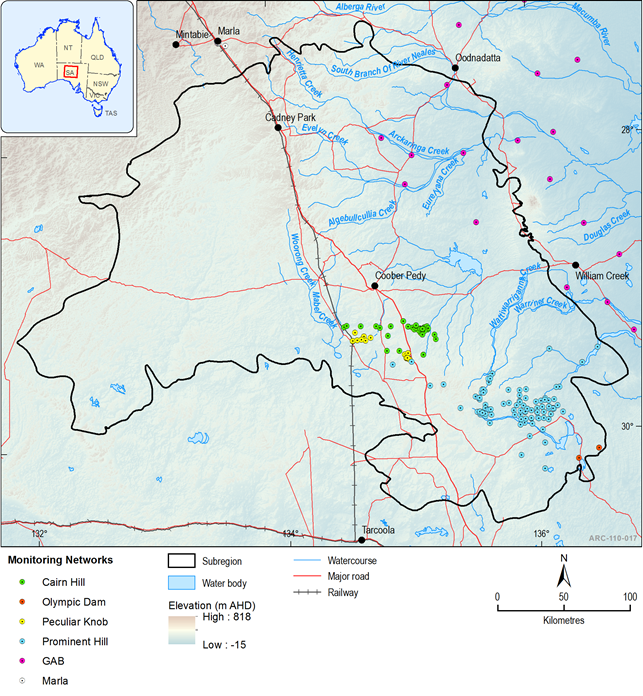
Figure 28 Groundwater monitoring networks within the Arckaringa subregion
Last updated:
5 January 2018

Summary and download
Product Finalisation date
2015
PRODUCT CONTENTS
ASSESSMENT
ASSESSMENT COMPONENT