Summary
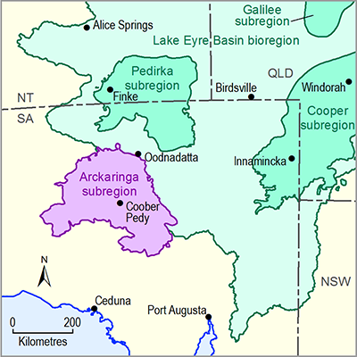
The Arckaringa subregion is located in northern SA, approximately 600 km north-northwest of Adelaide. The Arckaringa subregion is composed of a largely flat-lying, desert landscape of sand dunes and gibber planes and vegetation adapted to surviving in an arid climate.
Coober Pedy is the largest town within the subregion, with a population of approximately 2000 people. Other towns of significance immediately outside the subregion include Roxby Downs, Marla and Oodnadatta. Parts of the Maralinga Tjarutja and the Pitjantjatjara, Yankunytjatjara and Ngaanyatjarra (or Anangu) Indigenous freehold lands are situated within the subregion.
The pastoral industry represents the predominant land use across the subregion, while mining and tourism are increasingly becoming important industries.
With respect to water use in the Arckaringa subregion, the majority of water supply is derived from groundwater as surface water resources are small and unreliable. Of the groundwater supplies present, most is taken from the Great Artesian Basin (GAB), with some supplies derived from the underlying Arckaringa Basin.
The climate of central Australia is generally arid. Central Australian weather is dominated by persistent high pressure systems, which have an important influence on temperatures in the subregion. Any rainfall the subregion receives predominantly comes from weak winter cold fronts originating from the Southern Indian Ocean or sporadic summer monsoon rainfall that originates in northwest Australia; rainfall for the region averages 150 mm/year, although this can vary significantly from year to year.

Product Finalisation date
- 1.1.1 Bioregion
- 1.1.2 Geography
- 1.1.3 Geology
- 1.1.4 Hydrogeology and groundwater quality
- 1.1.5 Surface water hydrology and surface water quality
- 1.1.6 Surface water – groundwater interactions
- 1.1.7 Ecology
- Citation
- Acknowledgements
- Contributors from the Government of South Australia
- Contributors to the Technical Programme
- About this technical product
