- Home
- Assessments
- Bioregional Assessment Program
- Arckaringa subregion
- 1.1 Context statement for the Arckaringa subregion
Executive summary

The context statement brings together what was known about the geography, geology, hydrology and ecology of the Arckaringa subregion, as at July 2015.
Geography
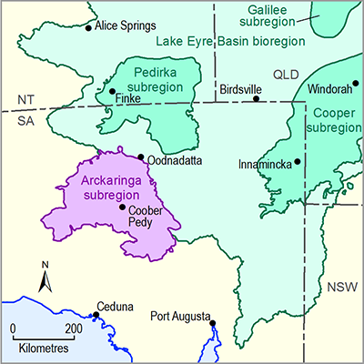
The Arckaringa subregion is part of the Lake Eyre Basin bioregion. It is located in northern South Australia and covers an area of about 82,500 square kilometres. The subregion overlies the geological Arckaringa Basin and is part of Australia's arid zone.
There are four main biogeographic areas: Stony Plains, Simpson Strzelecki Dunefields, Gawler Ranges and Great Victoria Desert.
Coober Pedy is the largest town in the subregion with a population of approximately 2000 people. Parts of the Maralinga Tjarutja and the Pitjantjatjara, Yankunytjatjara and Ngaanyatjarra (or Anangu) Indigenous lands are included in the subregion.
The major economic activity in the subregion is farming, while mining and tourism are becoming increasingly important activities.
Geology
The Arckaringa Basin is a horseshoe-shaped sedimentary basin. It was formed by a series of major tectonic events followed by glacial activity. Some of the oldest sedimentary rock in the basin was deposited about 300 million years ago. Most of the basin is now buried by younger rocks and sediments, and there are only minor surface exposures of the Arckaringa Basin.
There are three main geological formations within the Arckaringa Basin: the Boorthanna, Stuart Range and Mount Toondina formations. Overlying these three formations is the Eromanga Basin, which is part of the Great Artesian Basin. It is made up of layers of permeable sandstone, plus impermeable siltstone and mudstone.
Surface water and groundwater
The Arckaringa subregion is highly dependent on groundwater because surface water is so sparse and unreliable. Most groundwater is drawn from the Eromanga Basin. There are two other major aquifers in the Arckaringa subregion, the Boorthanna and the Mount Toondina formations. The groundwater from both is generally described as brackish to ultra-saline and is used predominantly for mining-related activities at the Prominent Hill copper and gold mine.
The Neales catchment is the major surface water drainage system within the Arckaringa subregion and drains into Kati Thanda – Lake Eyre. Since 2000, several information-gathering projects have started in the Neales-Peake catchment with data being used in hydrologic modelling undertaken by the South Australian Government.
Ecology
The ecology of the Arckaringa subregion is heavily influenced by its climate. Rainfall is highly variable and the soil is of poor quality. This has led to the evolution of a diverse range of plants and animals. Those that do remain are hardy and have adapted well to the extreme conditions.
During boom times following one of the large but infrequent floods, there is extraordinary growth. However these 'boom' conditions are inevitably followed by long dry spells when plants and animals rely heavily on isolated waterholes and springs—some of these have flowed continuously for more than 465,000 years. In drought the permanent Algebuckina Waterhole supports a diverse range and a high proportion of endemic species.
To the west of the Lake Eyre Basin bioregion there are dune lakes and depressions in the Great Victoria Desert and minor drainages, gilgais and cracking clay plains in the Stony Plains. These systems are filled very occasionally with rain and support unique desert life and nomadic waterbirds. These systems are very poorly studied.
Given the extreme conditions of this subregion there are a significant number of species with national, state or regional conservation status ratings.

- 1.1.1 Bioregion
- 1.1.2 Geography
- 1.1.3 Geology
- 1.1.4 Hydrogeology and groundwater quality
- 1.1.5 Surface water hydrology and surface water quality
- 1.1.6 Surface water – groundwater interactions
- 1.1.7 Ecology
- Citation
- Acknowledgements
- Contributors from the Government of South Australia
- Contributors to the Technical Programme
- About this technical product
