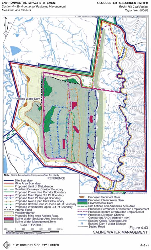
As of June 2015, NSW Department of Planning and Environment placed the Rocky Hill Coal Project on hold. The information summarised in this section was obtained from the Rocky Hill Coal Project environmental impact statement (R.W.Corkery & Co. Pty Ltd, 2012a, 2012b) and the Rocky Hill Coal Project Groundwater Assessment (Australasian Groundwater and Environmental Pty Ltd, 2013). As of June 2015, no water management plan document exists for the Rocky Hill Coal Project. The Project plans to manage the water in contact with the disturbed area in the on-site storage areas with no outflow. Water for the mine operations would be obtained from the following sources listed preferentially in order of use (with appropriate licences in place, where required):
- groundwater and surface water accumulating within the various open-cut pits throughout the 21-year life of the proposal
- surface water drawn from on-site environmental or sediment dams
- extract water from Waukivory Creek and/or the Avon River within the limitation of the Applicant's current entitlement to extract groundwater from alluvium under water access licences of 267 ML/year or purchased licences.
Prior to Year 8 of mining and following periods of high rainfall, any water accumulating in the open-cut pits would be pumped to either or all of the Environmental dams 1, 2 and 3 (EDI, ED2 and ED3) positioned immediately east of the western and northern visibility barrier (Figure 20). The capacities of ED1, ED2 and ED3 would vary throughout their operational lives to accommodate the changing layout within the mine area. ED1, ED2 and ED3 would have capacities of approximately 50 to 300 ML, 800 ML and 1200 ML respectively. Post Year 8, excess saline water from the main pit would be pumped to defined soakage areas within the Weismantel and Avon pits where the water would be stored in the pore space within the backfilled pits. The Rocky Hill Coal Project is also planning to construct a soaking pit with a depth of 5 m to store water temporarily and to pump water into the backfilled former open-cut void. The upper water levels in any soaking area would be set at approximately 2 m below the final landform surface. It is predicted that the total inflow to the four open-cut voids will be on average 640 ML/year with a peak inflow of 1250 ML/year in Year 4 of mining.
At maximum production of coal, the Rocky Hill Coal Project estimates the on-site water usage for operational purposes would be as follows:
- CHPP – up to 400 ML/year
- dust suppression (roads, stockpiles, crushing station, coal transfer points, etc.) – 350 ML/year
- offices and amenities area and workshops – 6 ML/year (i.e. 0.04 ML per person/year).
Figure 20 Saline water management for Rocky Hill Coal Project in the Gloucester subregion
Source: R.W.Corkery & Co. Pty Ltd (2012b) © Gloucester Resources Ltd 2013 (Australian Copyright)
The water balance estimations for the proposal (WRM Water & Environment Pty Ltd, 2013) has established that the water requirements for both the CHPP and dust suppression could be satisfied through the use of the saline water and/or surface water accumulating in the open-cut pits. The water balance has established there would be excess quantities of saline water from time to time throughout the proposed 21-year life of the project, some of which could be used to reduce dust lift-off from the active overburden emplacements.

Product Finalisation date
- 2.1.1 Geography
- 2.1.2 Geology
- 2.1.3 Hydrogeology and groundwater quality
- 2.1.4 Surface water hydrology and water quality
- 2.1.5 Surface water – groundwater interactions
- 2.1.6 Water management for coal resource developments
- Citation
- Acknowledgements
- Currency of scientific results
- Contributors to the Technical Programme
- About this technical product

