The dominant recharge mechanism in the geological Sydney Basin is likely to be infiltration of rainfall and runoff through alluvial deposits in valleys, particularly where they are incised into weathered Hawkesbury Sandstone (Parsons Brinckerhoff, 2011). Similarly, recharge through infiltration takes place where the underlying units of the Narrabeen Group outcrop. Towards the west, groundwater recharge to the Hawkesbury Sandstone occurs on the Blue Mountains plateau (west of the Lapstone Structural Complex) (Webb et al., 2009). Recharge for deeper sandstone aquifers comes mainly from infiltration of rainfall over outcropping areas and through inter-aquifer leakage (SCA, 2012). In the Southern Coalfields, the deeper aquifers occurring in the Bulgo and Scarborough sandstones (Narrabeen Group) outcrop in the valleys of the Cordeaux and Avon reservoirs and thus recharge is expected at times of higher water level (SCA, 2012).
In general, the hydraulic conductivity of shallow unconsolidated materials associated with alluvial deposits and soils is comparatively higher than the hydraulic conductivity of deeper consolidated rocks present in the Wianamatta Group, Hawkesbury Sandstone and Narrabeen Group (Table 12). Shallow groundwater through unconsolidated and surface material flows much faster than through consolidated rocks in the Wianamatta Group (Stammers, 2012; Bradd et al., 2012). Main discharges from the aquifer systems occur naturally at the surface to creeks and to the reservoirs as baseflow and seeps, and by evapotranspiration through vegetation.
On a local scale, topography controls the groundwater flow near the ground surface in alluvial and shallow aquifers. In these systems, groundwater flow is likely to be localised and limited in extent, with occurrence of perched aquifers controlled by the presence of fine-grained materials. In general, these systems are responsive to rainfall and streamflow (SCA, 2012). On a regional scale, SCA (2012) describes the groundwater flows for the geological Sydney Basin as being controlled by the basin geometry, topography and major hydraulic boundaries (Figure 35). In the south-central area of the basin regional groundwater flow is predominantly towards the north or north-east, eventually discharging via the Georges, Parramatta or Hawkesbury river systems, and ultimately offshore to the east (SCA, 2012; Parsons Brinckerhoff, 2013).
Across the geological Sydney Basin, it is generally accepted that groundwater flow is predominantly in the horizontal direction given the enhanced flow along bedding plane joints in sandstone formations (Ward and Kelly, 2013). Generally, the low permeability claystones overlying the coal measures throughout the basin behave as a hydraulic barrier limiting vertical flux exchange between deep coal measures and porous sandstones (SCA, 2012; Ward and Kelly, 2013). Ward and Kelly (2013) recognise that the presence of permeable fault zones might enhance the fluid connectivity between rocks above and below the claystones.
Towards the west of the geological Sydney Basin, groundwater flows eastwards across the Lapstone Structural Complex towards the Nepean River and Cumberland Plain (Webb et al., 2009).
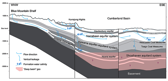
Source: Michael et al. (2009) (the stratigraphic framework modified by Michael et al. (2009) from Harrington et al. (1989)). This figure has been reproduced with the permission of CO2CRC.
