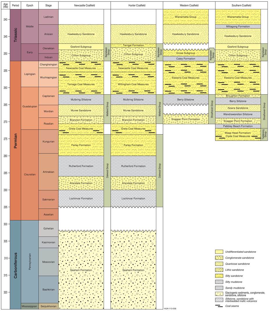
In this section, the stratigraphy and rock types of the Southern and Western coalfields (Figure 28) are presented, with a focus on the coal-bearing stratigraphic units and main non-coal units. For reasons identified in Section 1.1.3.1, the Central Coalfield is not specifically dealt with here, but the available data indicates that the stratigraphy of the Central Coalfield closely mirrors that of the Southern Coalfield (Haworth, 2003). A detailed analysis of all stratigraphic units recognised in the Australian Stratigraphic Units Database (Geoscience Australia and Australian Stratigraphy Commission, 2016) is not included here. Further information about the coal-bearing units, current mining operations and proposed development in this bioregion is provided in companion product 1.2 for the Sydney Basin bioregion.
1.1.3.2.1 Permian sedimentary rocks
Talaterang Group
Known from the southern part of the Sydney Basin (Southern Coalfield), the Talaterang Group was deposited in the early Permian through fluvial transport within deeply incised valleys. These are thought to be remnant glacial features located within early formed north-trending fault-bound sub-basins (Herbert, 1972; Brakel, 1991, p. 14; Tye et al., 1996) which rest directly on the underlying basement rocks (Ward and Kelly, 2013; Tye et al., 1996). The Talaterang Group is composed of the Badgerys Breccia, Clyde Coal Measures, Pigeon House Creek Siltstone and Wasp Head Formation (Figure 28; Geoscience Australia and Australian Stratigraphy Commission, 2016). The Clyde Coal Measures formed in a transgressive depositional cycle in the south of the Sydney Basin, with marine transgression moving across the basin from the east to the west (Brakel, 1991, p. 15). The formation of the Clyde Coal Measures has been attributed to the marshlands of a delta complex (Evans et al., 1983), where the mud-rich sediment was deposited in northerly flowing channels (Tye et al., 1996). As the rising ocean moved westward across the Sydney Basin the Clyde Coal Measures were deposited in paralic zones, forming lenses of coal (Evans et al., 1983; Brakel, 1991, p. 15). The Talaterang Group contains limited economic coal resources due to the thin nature of coal seams within the Clyde Coal Measures (Hutton, 2009, p. 43), although some mining has occurred historically.
Shoalhaven Group
Coincident with the early Permian marine transgression was the deposition of thick sand and silt units of the Shoalhaven Group (Figure 28) across the Southern and Western Coalfields. These were deposited in variably low to high energy, fluvial to marine (shelf) environments (Brakel, 1991, p. 15; Tye et al., 1996) and mainly comprise sandstone with interbedded shale and mudstone (Hutton, 2009, p. 43). The shale and mudstone units represent marine influenced deposition, whereas the sandstone units are fluvial to terrestrial in origin (Hutton, 2009, p. 43). The Shoalhaven Group consists of the Pebbley Beach Formation, Snapper Point Formation, Wandrawandian Siltstone, Nowra Sandstone, Berry Siltstone and Broughton Formation (Geoscience Australia and Australian Stratigraphy Commission, 2016). The Shoalhaven Group also contains a coal-bearing unit of low economic importance, the Yarrunga Coal Measures (Yoo et al., 2001, p. 9; Hutton, 2009, p. 43). In the Southern Coalfield the Shoalhaven Group overlies the Talaterang Group. Within the Western Coalfield the Shoalhaven Group is divided into the sandstone rich Snapper Point Formation and the Berry Siltstone which are separated by an unconformity relating to depositional hiatus (Yoo et al., 2001, p. 10).
Data: produced for Bioregional Assessment Programme based on stratigraphic unit information from Geoscience Australia and Australian Stratigraphy Commission (2016)
This figure has been optimised for printing on A3 paper (297 mm x 420 mm).
Illawarra Coal Measures
Considered to be an approximate equivalent of the Tomago, Newcastle and Wittingham coal measures in the Newcastle and Hunter Coalfields (Ward and Kelly, 2013), the Illawarra Coal Measures are composed of sandstone, siltstone, claystone and coal. There are also some minor tuff and conglomerate layers, with rare basalt noted within the Southern Coalfield only (Bamberry, 1991, pp. 52–79; Ward and Kelly, 2013). The formation of these coal measures occurred in lower delta plain to alluvial fan environments (Bamberry, 1991, p. 47). The Illawarra Coal Measures reach a maximum thickness in the north of the Southern Coalfield (over 500 m of vertical succession) and are thinnest (less than 100 m) to the south-east of the same coalfield (Bamberry, 1991, p. 47; Ward and Kelly, 2013). In the Southern Coalfield the Illawarra Coal Measures are divided into two subgroups, the Cumberland Subgroup (the basal section) and the Sydney Subgroup (Bamberry, 1991, p. 47; Hutton, 2009, p. 44). The Cumberland Subgroup is considered to contain limited coal and in low quantities that make it economically unimportant (Bamberry, 1991, p. 47). This subgroup contains marine, marginal marine and volcanic latite facies (Bamberry, 1991, p. 47). In the Southern Coalfield, the Sydney Subgroup contains all of the economic coal reserves of the Illawarra Coal Measures (Bamberry, 1991, p. 48). It is composed of conglomerate, sandstone, conglomeratic sandstone, coal, claystone, siltstone and some tuff (Bamberry, 1991, p. 48). Coal is mined from a wide range of depths within the Southern Coalfield from open-cut mines and underground mines. The two most productive coal-bearing units in the Southern Coalfield are:
- The Bulli Coal which varies in depth from surface (open-cut mining in the Wollongong-Coalcliff region) down to about 850 metres in the north-west of the Southern Coalfield (Moffitt, 2000).
- The Wongawilli Coal which varies in depth from near surface to 900 metres (Moffitt, 2000).
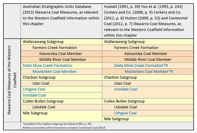
The Illawarra Coal Measures of the Western Coalfield are subdivided into seven main constituent units (Australian Stratigraphic Database, 2015). These are the Nile, Cullen Bullen, Charbon and Wallerawang subgroups and State Mine Creek Formation, the Lithgow Coal and the Irondale Coal (Australian Stratigraphic Database, 2015). Further internal divisions of the Cullen Bullen, Charbon and Wallerawang subgroups and State Mine Creek Formation are shown in Figure 29, relevant to the Western Coalfield (Australian Stratigraphic Database, 2015). However due to differences in the stratigraphic hierarchy between authors, industry and governing bodies, the coal of the Western Coalfield is at times divided into four main intervals (Figure 29) where the State Mine Creek Formation, Lithgow and Irondale coals are placed within other subgroups (Huleatt, 1991, p. 39; Yoo et al., 1995, p. 243; Corkery and Co., 2008, p. 9; Corkery and Co., 2012, p. 8; Hutton 2009, p. 53; Centennial Coal, 2012, p. 7).
The Nile Subgroup was formed in a prodelta to lower delta plain environment (Yoo et al., 2001, p. 15). The Cullen Bullen Subgroup formed in fluvial to delta and alluvial plain environments (McVicar et al., 2015). The Charbon Subgroup formed as a delta system with some marine influence (McVicar et al., 2015). The Wallerawang Subgroup is composed of alluvial and floodplain deposits (Yoo et al., 1991, p. 240). The coal measures vary in thickness across the Western Coalfield and are thinnest near the western boundary (50 m), and thickest near the eastern boundary (900 m) (Hutton, 2009, p. 51; Ward and Kelly, 2013). The Lithgow, Lidsdale, Ulan and Katoomba coals are the dominant units of economic interest in the Western Coalfields, with the Irondale Coal and Middle River Coal Member of localised interest (Ward and Kelly, 2013). The deepest of these seams, the Lithgow Coal, is up to 600 m below the surface at its deepest, but occurs at the surface in some localised areas of lower elevation. The Katoomba Coal Member is the shallowest unit and outcrops at the surface or is close to the surface over much of its extent.
1.1.3.2.2 Triassic sedimentary rocks
Narrabeen Group
In the Southern Coalfield the Narrabeen Group is divided into two subgroups: the Clifton and Gosford Subgroups (Hutton, 2009, p. 43). The Narrabeen Group is a Lower Triassic non-coal-bearing stratigraphic unit (Hutton, 2009, p. 43). The group is composed mainly of quartz-rich sandstone, shale and mudstone (Hutton, 2009, p. 43) which were formed within several different fluvial environments (Ward, 1972). Evidence of deposition in alluvial fan, braided and meandering stream and delta plain environments are all recognised within the Narrabeen Group (Ward, 1972). Formation of the Narrabeen Group was associated with a relatively slow period of marine transgression, characterised by sediment starvation through declining erosion at the sediment source (Ward, 1972). The dominant direction of deposition is thought to be towards the south and south-west, with some periodic influxes from the east (Ward, 1972).
The subdivision of the Narrabeen Group of the Western Coalfield is considered uncertain due to the lack of drilling to significant depths and so correlation of the group in the north and the south is approximate (Hutton, 2009, p. 51). The sequence has a maximum thickness of 656 m but is thinner near the west of the coalfield (Yoo et al., 2001, p. 52). However, in the north of the Western Coalfield the Narrabeen Group is reminiscent of the Digby Formation (part of the stratigraphy in the neighbouring Gunnedah Basin) and is composed of conglomerate, sandstone, quartz sandstone and siltstone (Yoo et al., 2001, p. 52).
Hawkesbury Sandstone
The Triassic aged quartz-rich Hawkesbury Sandstone has a maximum stratigraphic thickness of between 250 and 290 m (Conaghan and Jones, 1975; Australian Stratigraphic Database, 2015). Some mudstone is present within this formation, with Conaghan and Jones (1975) estimating a mudstone to sandstone ratio of 20:1 in favour of sandstone. Although some refer to the Hawkesbury Sandstone as a massive sandstone unit (Jones and Rust, 1983), Conaghan and Jones (1975) referred to known areas of cross-sets in a ‘sheet facies’ where cross-sets range in size from a few centimetres to a few metres. Deposition is thought to have been influenced by strong currents in shallow marine, littoral, estuarine, fluvial, lacustrine or aeolian environments (Conaghan and Jones, 1975). A braided stream environment with massive (up to 15 m) floodplain deposit formation is described for the massive sandstone, and was favoured among researchers (Jones and Rust, 1983). Miall and Jones (2003) found that fluvial modelling of the Hawkesbury Sandstone indicated channel belts in excess of 2.5 km wide. Deposition is thought to have occurred in a north-easterly direction (Ward, 1972). Towards the eastern boundary of the Western Coalfield the Hawkesbury Sandstone reaches a thickness of around 244 m, thinning to the west and becoming only 52 to 55 m thick within a minimum distance of 25 km (McVicar et al., 2015).
Mittagong Formation
The Mittagong Formation is a coal-barren unit, formally known as the Passage Beds, which represents the gradational change from the underlying Hawkesbury Sandstone to the overlying Wianamatta Group (Bamberry, 1991, p. 47). Interbedded shales and fine-grained sandstone layers have maximum thickness of 15 m (Bamberry, 1991, p. 47; Ward and Kelly, 2013).
Wianamatta Group
The Middle Triassic aged Wianamatta Group was deposited during a single marine regression (Herbert, 1979). The group is subdivided into three units, the Ashfield Shale, Bringelly Shale and Minchinbury Sandstone; both the Ashfield Shale and the Bringelly Shale are further subdivided into several constituent units (Herbert, 1979; Geoscience Australia and Australian Stratigraphy Commission, 2016). The lowermost Ashfield Shale consists of a gradational sequence of lacustrine through to marine or brackish facies (Herbert, 1979). The Minchinbury Sandstone is the continuing gradation of the move to shoreline facies, particularly beach and barrier bar environments (Herbert, 1979). The uppermost Bringelly Shale initially formed in lagoonal and marsh environments but slowly graded into alluvial or estuarine coastal plain facies (Herbert, 1979). Hutton (2009, p. 43) stated that the Wianamatta Group only occurs within the northern portion of the Southern Coalfield. Only a single subunit of the Wianamatta Group is recognised in the Western Coalfield, the Ashfield Shale (McVicar et al., 2015).
1.1.3.2.3 Permian to Triassic igneous rocks
Beginning at the Permo-Triassic boundary, basaltic igneous intrusions pierce the stratigraphic record of the Sydney Basin bioregion (Ward and Kelly, 2013). These basaltic intrusions continued sporadically into the Neogene (Ward and Kelly, 2013). A rhyolitic to dacitic pyroclastic igneous formation, the Rylstone Volcanics, are composed of tuffaceous sandstone, breccia, conglomerate, siltstone, thin airfall tuff beds and flow banded rhyolite lavas (Geoscience Australia and Australian Stratigraphy Commission, 2016). It underlies the Permian Shoalhaven Group (Geoscience Australia and Australian Stratigraphy Commission, 2016). A late Permian volcanic complex consisting of small dykes and sills, and large sheet intrusion, form the Coonemia Complex in the vicinity of Nowra (Carr, 1997).
1.1.3.2.4 Jurassic to Quaternary rocks
Sedimentary rocks
Jurassic and Cretaceous sedimentation took place in the north of the Western Coalfield, depositing the Purlawaugh Formation, Pilliga Sandstone and the Bungil Formation (Yoo et al., 1995, p. 234); these are discussed in Section 1.1.3 of companion product 1.1 for the Hunter subregion (McVicar et al., 2015). However, to the south of the Western Coalfield and within the Southern Coalfield, the deposition of Jurassic sedimentary rocks is speculative, as there is no existing stratigraphic record for that time period (Philp and Saxby, 1980). From the Cretaceous into the Quaternary, sedimentary processes continued across the Sydney Basin, depositing alluvium, colluvium, gravels, sands, silts, clays, peat, cemented conglomerates, and laterites (Herbert, 1983a; Stroud et al., 1985; Watkins et al., 1997; Thomas et al., 2013). The distribution of surface geology in the Sydney Basin bioregion (Figure 24) can be described as dominantly Triassic and Permian, with notable deposits of Quaternary alluvium.
Igneous rocks
The basaltic intrusions previously mentioned (see Section 1.1.3.2.3) continued through the Jurassic and Cretaceous into the Paleogene and Neogene (Ward and Kelly, 2013). Basaltic flows from the Paleogene occur in the Southern Coalfield’s Mittagong region (Ward and Kelly, 2013). The youngest of these basaltic intrusions are in places covered by unconsolidated fluvial and coastal sediment ranging in age from Paleogene to Quaternary (Ward and Kelly, 2013). Dyke and sill intrusion occurred commonly in the Paleogene and Neogene (Ward and Kelly, 2013). No igneous activity is known after the Neogene.
The Jurassic aged intrusive Mount Gibraltar Microsyenite is dominantly composed of syenite (Ward and Kelly, 2013). The Mount Gibraltar Microsyenite intrudes the Wianamatta Group (Bodorkos, 2010, p. 87). The Mount Gibraltar Microsyenite is found at Mount Gibraltar, Mount Jellore and Mount Flora in the Mittagong region of the Southern Coalfield (Ward and Kelly, 2013). The syenite intrusive is also found as a sill at Mount Alexander intruding the Wongawilli Coal (Ward and Kelly, 2013).
Diatremes occur across the basin and are filled with volcanic breccia (Crawford et al., 1980, p. 296; Ward and Kelly, 2013). Crawford et al. (1980, p. 296) stated that 95 diatremes are known within the Sydney Basin, and another 60 were inferred. Branagan and Packham (2000) later downgraded this estimate to just over 30 diatremes. The diatremes are believed to be Jurassic in age (Crawford et al., 1980, p. 298). The internal breccia is largely composed of volcanic (amygdaloidal and basaltic) fragments set in a tuffaceous matrix, though sandstone and shale fragments also occur (Crawford et al., 1980, p. 313).
