1.1.4.1.1 Hydrogeological characteristics of the Sydney Basin bioregion
The southern part of the geological Sydney Basin is primarily a Permian-Triassic sedimentary rock sequence underlain by undifferentiated sedimentary rocks of Carboniferous and Devonian age (see Figure 24 and Figure 28 in Section 1.1 .3). Regional aquifers containing groundwater of a quality and yield suitable for large-scale development are not present in the geological Sydney Basin, however, locally there are important aquifers within the Hawkesbury Sandstone and Narrabeen Group (Ross, 2014) and unconsolidated alluvial aquifers associated with present-day drainage networks and coastal deposits.
Across the bioregion, sandstone units behave as porous and fractured rock aquifers whereas claystones and shales behave as aquitards, with generally variable water quality (AGL, 2013).
The main groundwater systems are associated with the following geological features:
- Unconsolidated Cenozoic alluvial (along river floodplains) and dune/beach deposits (for example, the Botany Sand Beds (BSB))
- Upper Triassic Wianamatta Group rocks where minor aquifers and aquitards occur (Bringelly Shale, Minchinbury Sandstone, and Ashfield Shale)
- Middle Triassic Hawkesbury Sandstone aquifers (including Newport and Garie formations of the Narrabeen Group)
- Lower Triassic Narrabeen Group sandstone aquifers (Bulgo and Scarborough sandstones)
- Permian water-bearing units (Illawarra Coal Measures).
Figure 31 shows the surface extent of these geological features across the bioregion.
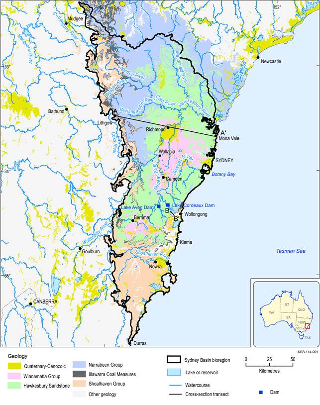
Figure 31 Surficial extent of main hydrogeological units in the Sydney Basin bioregion
Transects A-A’ and B-B’ are approximate locations of geological cross-sections presented in Figure 32 and Figure 33
Data: Geoscience Australia (Dataset 1)
Figure 32 is a schematic geological cross-section in a west to east direction across the Sydney Basin bioregion (transect A-A’ in Figure 31 from Lithgow to Mona Vale), which illustrates the layering of the main geological formations.
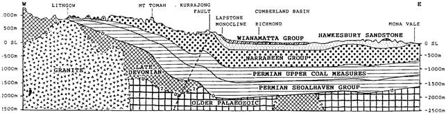
Figure 32 Schematic west to east geological cross-section of the Sydney Basin bioregion
The transect extends from Lithgow in the west and traverses through Mount Tomah and Richmond to Mona Vale in the east
Source: Australian Plants Society, North Shore Group (2011)
Unconfined Cenozoic alluvial/sediment aquifers
Alluvial deposits occur along the valleys, creeks and floodplains of the main rivers in the region: Nepean, Hawkesbury, Georges and Shoalhaven (shown in Figure 10 in Section 1. 1.2). These deposits are generally shallow, forming unconfined aquifers that are responsive to rainfall and streamflow. Together with shallow underlying sandstone units they provide low to medium bore yields and have hydraulic transmissivities greater than 20 m2/day (Parsons Brinckerhoff, 2013). In the geological Botany Basin in southern Sydney significant unconsolidated coastal sand and dune deposits form the BSB.
Nepean River
Around the Camden area, the alluvial deposits of the Nepean and paleo-Nepean River have watertable levels close to 6 m below the surface, low to medium bore yields (mean of 0.2 ML/day extracted from 33 bores) and levels of total dissolved solids (TDS) (salinities) around 2150 mg/L TDS (AGL, 2013).
Hawkesbury River
The alluvial deposits of the Hawkesbury River, extending downstream of Warragamba Dam to the township of Spencer, are referred to as the Hawkesbury Alluvium Groundwater Source. Alluvial deposits are broadest in the Windsor to Wilberforce area with most bores drilled in thinner alluvia of minor tributaries. High salinity values may limit the potential use of groundwater in several areas of these alluvial deposits (NSW Government, 2011). The Hawkesbury alluvium is a significant alluvial groundwater system with reasonable levels of storage (NSW Government, 2015).
Around the Penrith-Richmond area in the eastern ridge of the Blue Mountains, Quaternary alluvial deposits associated with the Hawkesbury River are mostly a mixture of clean quartz sand and cobbles with interbeds up to 20 m thick of yellow clay. They are distinctly different from the Paleogene–Neogene alluvial deposits, which are richer in clay content (Green et al., 2010).
Georges River
Quaternary and Paleogene-Neogene alluvium along the Georges River contains a shallow, unconfined aquifer which is likely hydraulically connected to the Georges River (Parsons Brinckerhoff, 2014). Hydraulic testing indicates that hydraulic conductivities in the alluvium range from 0.003 to 0.1 m/day. On a regional scale, groundwater flow in the alluvium is towards the north-north-east, following the flow direction of the Georges River. Groundwater levels in the alluvial aquifer are relatively shallow (<5 m below ground level) (Parsons Brinckerhoff, 2014). Around Liverpool South, Parsons Brinckerhoff (2011) reported a water level of 8.5 m below the surface and a low bore yield of 0.01 ML/day at one bore within the alluvial aquifer.
The Ashfield Shale, which is part of the Wianamatta Group (see Figure 28 in Section 1.1. 3), can be found around the alluvial deposits of the Georges River. This unit varies between 3 and 10 m in thickness, has hydraulic conductivities between 0.01 and 0.08 m/day and behaves as an aquitard. The underlying Hawkesbury Sandstone aquifer is unlikely to influence shallow groundwater flows given the presence of this aquitard (Parsons Brinckerhoff, 2014).
Shoalhaven River South Coast Alluvium
Around Nowra, alluvial aquifers associated with creeks and tributaries to the main Shoalhaven River occur as sand, silt, clay and gravel flanking the creek systems and as more widespread floodplain deposits. Water movement in these deposits occurs as intergranular flow through the preferential pathways provided by interconnected, higher permeability sand and gravel lenses. Within the Broughton Creek floodplain sediments, localised perched groundwater aquifers occur above interbedded clay horizons. Groundwater is typically shallow, between 0.5 and 4 m below the surface. Groundwater movement within the alluvial aquifer and floodplain sediments is towards low-lying topographic features, discharging into local creek systems or as springs (NSW Government, 2013).
South of Nowra in the Jervis Bay area, unconsolidated sand aquifers overlying Triassic sandstones show a rapid response to rainfall pulses. Historical water levels in selected bores around Lake Windermere range between 2 and 11 m below the surface with transmissivity values of 2700 m2/day (Jacobson and Schuett, 1984).
Botany Basin (Botany Sand Beds)
The geological Botany Basin in southern Sydney (enclosing Botany Bay in Figure 31), originated from preferential erosion of the Paleogene-Neogene coastline and major paleodrainages of the older Triassic bedrock formations, which comprise interbedded shales and sandstones of the Ashfield Shale overlying the medium- to coarse-grained quartz sandstones of the Hawkesbury Sandstone. Numerous erosional episodes interrupted the sedimentary depositional environment, with the sedimentary column reflecting this transition. The Botany Sand Beds (BSB) dominate the sedimentary column of the geological Botany Basin and comprise up to 30 m of uniformly graded, well-sorted, clean and poorly cemented fine- to medium-grained quartz sands, with an average of 15 m saturated sand (Hatley, 2004; EA, 2007). These sand beds are underlain by clay and clay-rich quartz sand lenses and a basal unit consisting of fluvial and aeolian medium-grained sands with gravel lenses, together having a maximum thickness of around 45 m (Hatley, 2004). This sequence of unconsolidated sands of the geological Botany Basin generally makes for a productive aquifer.
At a larger scale, there exist two groundwater systems: one within the bedrock sequences of the Hawkesbury Sandstone; the other in the overlying unconsolidated sedimentary material, termed the BSB. Interactions between these two groundwater systems is acknowledged although not well understood (Hatley, 2004).
Groundwater recharge to the BSB is primarily from rainfall, with minor contributions from irrigation, leaky service mains and flow from the underlying bedrock units. For the BSB, infiltration from rainfall averages 22 and 44 ML/day for dry and wet periods, respectively (Badenhop and Timms, 2009).
Groundwater flow in the BSB follows the topographic gradient and is mainly inward towards Botany Bay. Water levels vary between 0 and 25 m depth below the surface, with the majority of the geological Botany Basin showing a mean depth of around 9 m. The BSB is mostly unconfined with the exception of semi-confined areas underlying discontinuous bands, beds and lenses of clay, silt, peat or an erosional discontinuity of intermittently cemented and hard sandy material termed the ‘Waterloo Rock’. The groundwater flow direction is from the recharge areas in the north-east towards Botany Bay at a rate of about 150 m/year (Badenhop and Timms, 2009).
The BSB has a mean thickness of about 20 m, with up to 53 m depth in paleochannels incised in the basement rocks. Hydraulic gradients range from 0.003 to 0.01; hydraulic conductivities range between 1.4 and 85 m/day; porosities range between 0.33 and 0.40; transmissivities vary between 230 and 630 m2/day; and the storage coefficient varies between 0.17 and 0.26 (Hatley, 2004).
Wianamatta Group – minor aquifers and aquitards
The Wianamatta Group consists of three units: the Ashfield Shale, the Minchinbury Sandstone and the Bringelly Shale, with the Minchinbury Sandstone of negligible thickness (McNally, 2004). This group has a maximum thickness in western Sydney of up to 300 m, but with more typical thicknesses in the range of 100 to 150 m. The Wianamatta Group occurs as scattered remnant areas in the Southern Highlands, with major outcrops predominantly over the Cumberland Plain south-west of Richmond (Figure 31).
In western Sydney, two aquifer systems are associated with the shale formations of the Wianamatta Group. The upper aquifer system comprises residual soils and colluvium derived from the shales, floodplain alluvium and the weathered saprolite, and typically has a depth of 3 to 10 m. Hydraulic conductivities show a large variability and range between 0.01 and 10-5 m/day, with the higher end suggesting the presence of open fractures in weathered shales or ferricrete bands. The lower aquifer system occurs below the base of the weathering and comprises fine-grained mudrocks. This aquifer shows some degree of fracturing thus allowing some groundwater flows. Despite its low transmissivities, McNally (2004) refers to this system as an aquifer because it discharges small volumes of saline water to the surface. Hydraulic conductivities range between 0.001 and 10-8 m/day, with the lower end reflecting the intrinsic impermeability of the unfractured shale.
Both aquifers show limited storage and low bore yields, typically less than 0.1 ML/day (McNally, 2004; Parsons Brinckerhoff, 2013). Water-bearing fractures are widely spaced and sometimes poorly interconnected. This results in boreholes being dry when first drilled, then slowly filling with water over several weeks, causing substantial head and salinity variations in piezometers. Water within fractures is generally brackish to saline, especially in low relief areas, with typical values in the range of 5,000 to 50,000 mg/L TDS (McNally, 2004).
Green et al. (2009) and McLean and Ross (2009) argue that high salinity groundwater in this unit is due to the high proportion of soluble salts of marine origin available for dissolution, leaching and mobilisation. McNally (2004, 2009) argue that these rocks are not of marine origin, and that there is little pore space and the present rate of weathering is too small to produce such salinity values. As opposed to the marine origin model, McNally (2004, 2009) propose a depositional sea salt model in the form of saline rain as an alternative. He also explains the large temporal and spatial fluctuations in the salinity values as localised upward movements of salt water, cycles of dry/wet years, pressure fluctuations between shallow fresh water and deeper salt water in the shale terrain, and potential evaporation from the PVC tubing in piezometers or downward leakage of salty runoff around the piezometer seal.
Around Camden, 12 bores tapping the Wianamatta Group have a mean bore yield of 0.1 ML/day, a mean water level of 3.5 m below the surface and salinity around 2500 mg/L TDS (AGL, 2013).
Aquifers in the Wianamatta Group of the geological Sydney Basin are not typically targets for water supply due to lack of water-bearing zones, generally very low yields and in places highly saline groundwater (5,000 to >15,000 mg/L in Western Sydney area) (Russell et al., 2009).
Hawkesbury Sandstone aquifer
The Hawkesbury Sandstone is commonly grouped with the Newport and Garie formations of the Narrabeen Group and defined as the Hawkesbury Sandstone aquifer system (AGL, 2013). It occurs across the whole geological Sydney Basin and crops out over an area of about 20,000 km2, extending from the Southern Highlands to the Putty area in the north, and to the lower Blue Mountains (Lee, 2009) (Figure 31). Typically, it has a dual porosity with preferential flow dominated by secondary porosity and fracture flow along joints and/or shear zones.
The Hawkesbury Sandstone comprises friable, fine- to coarse-grained, mature and well-sorted quartzose sandstone with some shale lenses of limited areal extent, resulting in localised aquitards (Zaid and Al Gahtani, 2015). Mean estimates of the clay matrix content range from 20 to 40%. Individual sandstone beds usually occur as elongated lenses up to 10 m thick and 1 km long (Cendón et al., 2014). Beds in the Hawkesbury Sandstone have been classified into three facies types, which are summarised in Table 11 (Cendón et al., 2014).
Table 11 Summary of Hawkesbury Sandstone facies and hydrological characteristics (after Cendón et al., 2014)
The hydraulic conductivity of the Hawkesbury Sandstone is related to the rock defect characteristics, which are influenced by the depth and in situ stress conditions as well as the presence of regional structural features. Based on 370 packer tests around the Sydney metropolitan area, scaled geometric mean hydraulic conductivities have been found to range from 0.5 m/day at the surface to 0.01 m/day at 50 m depth. Tammetta and Hewitt (2004) reported a mean hydraulic conductivity for the Hawkesbury Sandstone matrix of about 0.0019 m/day, based on six cores at depths of 8 to 37 m. Viable groundwater resources have been identified at Kangaloon (Southern Highlands), Leonay-Emu (western Sydney) and Wallacia (south-western Sydney, Figure 31), with bore yields of up 3.5 ML/day from sites located on major faults or close to volcanic intrusive bodies (Hawkes et al., 2009; Ross, 2014).
At the south-western margins of the geological Sydney Basin, localised perched aquifers within the Hawkesbury Sandstone have been observed, where the underlying shales of the Berry Formation of the Shoalhaven Group create a basal aquitard (Aquaterra, 2011). Slightly higher hydraulic conductivities of 0.1 to 0.5 m/day have been reported, reflecting the locally weathered and friable nature of the sandstone. Groundwater salinity in the Hawkesbury Sandstone is generally low (<100 mg/L TDS), whereas the deeper Berry Formation has more saline groundwater (1000 mg/L TDS) (Aquaterra, 2011).
At the western fringe of the geological Sydney Basin, on the lower sections of the Blue Mountains, the Hawkesbury Sandstone hosts a series of multi-layered aquifers. Three main groundwater systems have been identified:
- A shallow unconfined aquifer in the upper sandstone aquifer, with topographically-driven groundwater flow and local discharge into hill-slope springs.
- Intermediate (possibly) perched aquifers likely to discharge to mid-level valleys.
- Deeper intermediate-scale dual porosity aquifers in the interlayered and fractured horizons of the sandstone discharging at lower levels in the landscape. This aquifer system is semi-confined to confined with the presence of artesian heads east of the Lapstone Monocline (see Figure 24 in Section 1.1 .3) (Green et al., 2010).
In the Camden area, salinities tend to be fresher south of the Nepean River because of the proximity to recharge areas (738 mg/L TDS mean from 45 bores). Further north, the Hawkesbury Sandstone is overlain by up to 60 m of Wianamatta Group shales and salinities increase to moderately saline, with values of 3760 mg/L for the basal sandstone and 6190 mg/L in shallower parts of the aquifer (AGL, 2013; Parsons Brinckerhoff, 2013).
The peat swamps on the sandstone rocks of the Blue Mountains (western area of the basin) form in gently sloping headwater valleys, broad valley floors and alluvial flats, gully heads and open depressions on ridgetops (Commonwealth of Australia, 2014). Water flows through the swamps as sheet flow through the peat sediments, whereas groundwater can discharge to these swamps along fractures, joints or bedding planes intersecting the peat swamp. Usually, these swamps are associated with local groundwater flow systems of short path and residence time. The connection between these swamps and groundwater relies on perched aquifer conditions and thus is likely to be ephemeral (Commonwealth of Australia, 2014).
The aquifer in the Hawkesbury Sandstone within the Southern Coalfields is considered a low-yield system of good quality. It is well-developed for commercial production in the Mangrove Mountain area north of Sydney and partially developed in the Blue Mountains west of Sydney and in the Southern Highlands at Kangaloon and at Leonay-Wallacia (Merrick, 2008).
The swamps on the sandstone rocks of the Woronora and Illawarra plateaux south of Sydney are important ecosystems containing a diversity of endemic flora and fauna species (Section 1 .1.7). These ecosystems contain threatened species and are classified as endangered ecological communities under the Commonwealth’s Environment Protection and Biodiversity Conservation Act 1999 (EPBC Act). Upland swamps on the Hawkesbury Sandstone terrain of the Woronora and Illawarra Plateaux are either headwater and/or drainage divide or valley fill swamps (Ross, 2009; Fryirs et al., 2014). The groundwater systems beneath the swamps are conceptualised as perched water-bearing zones occurring in colluvial sediments with regional (fractured and porous rock) aquifers occurring in the deeper Hawkesbury Sandstone. They can be important sources of baseflow to Sydney water supply during dry periods. Perched water-bearing zones associated with the upland swamps (particularly Stockyard Swamp and Butlers Swamp) have been shown during long pumping trials to be unaffected by drawdown in the deeper sandstone aquifers (Ross and Carosone, 2009). This suggests these perched water-bearing zones behave as independent hydraulic systems from the underlying regional sandstone aquifer and therefore some level of protection against deep mine dewatering could be expected.
Narrabeen Group – deeper minor aquifers
At the north-east margin of the geological Sydney Basin, the Hawkesbury Sandstone is underlain by the Lower Triassic Terrigal Formation, the uppermost unit of the Narrabeen Group (see Figure 28 in Section 1.1.3 for a generalised stratigraphic column). Its geologic time equivalent south of the Hawkesbury River is the Newport Formation. The Terrigal Formation comprises an interbedded sequence of sandstone, siltstone and claystone some 200 m thick (Cendón et al., 2014). The Terrigal Formation has a lower primary porosity than the overlying Hawkesbury Sandstone, reflecting its clay-silt matrix and smaller mean grainsize.
Further south, around Camden, the Lower Triassic Scarborough Sandstone, a coarse-grained lithic sandstone grading into conglomerate (Mayne et al., 1974), and the Lower Triassic Bulgo Sandstone (see Table 12) are considered to be minor aquifers with bore yields of up to 0.1 ML/day (AGL, 2013) (Figure 33). The layered aquifers in the Bulgo Sandstone have low transmissivities in the range 0.1 to 0.5 m2/day, whereas Madden (2010) suggests the Scarborough Sandstone is a dual porosity aquifer with dominant flow occurring in secondary rock features. The Bald Hill Claystone and Stanwell Park Claystone (Early Triassic) act as aquitards and limit the vertical flow of water between the Hawkesbury Sandstone and the Bulgo and Scarborough sandstones of the Narrabeen Group (Stammers, 2012; Bradd et al., 2012; McKibben and Smith, 2000; NSW Government, 2008).
Around the Southern Coalfields, the aquifers of the Narrabeen Group, Bulgo and Scarborough sandstones as well as the Bald Hill Claystone, outcrop in the valleys of the Cordeaux and Avon reservoirs (SCA, 2012). Figure 33 shows a schematic geological cross-section from the Kembla Creek arm of the Cordeaux Reservoir (transect B-B’ in Figure 31) to the eastern divide, indicating the interaction between the main aquifers of the Narrabeen Group and surface waters.
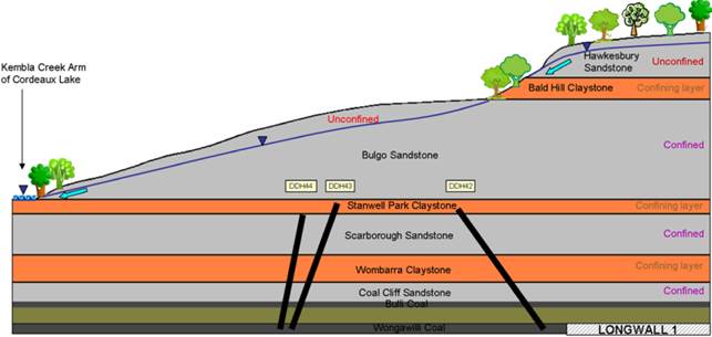
Source: Madden and Ross (2009)
Water quality in the Narrabeen Group is poorer than in the Hawkesbury Sandstone (Madden and Merrick, 2009), with salinities ranging from around 1500 to 5000 mg/L TDS (AGL, 2013).
1.1.4.1.2 Aquifers and confining layers
Bradd et al. (2012) proposed a hydrogeological conceptual model for the interaction between aquifers and confining layers present in the geological Sydney Basin (Sydney Metro, Southern Rivers and the Hawkesbury-Nepean Catchment) based on Reynolds (1976). An equivalent conceptualisation has been proposed by Stammers (2012) for the Southern Coalfields Figure 2 3 in Section 1.1. 3). This model suggests an anisotropic system where horizontal groundwater flow through more permeable bedding planes is significantly greater than vertical flow. Although vertical flow is typically minimal in the region (Stammers, 2012), a degree of vertical flow is expected through joints and vertical fractures. The model assumes a system of perched aquifers as well as deeper saturated layers underlain by less permeable strata. The result is that groundwater does flow downwards, but in a step-wise fashion through a network of semi-connected aquifers linked by zones of increased vertical and horizontal conductivity (Reynolds, 1976; Stammers, 2012 and references therein; Bradd et al., 2012). Figure 34 shows a conceptual model for the occurrence of perched aquifers and the impact on aquifer connectivity and groundwater flow paths of vertical jointing.
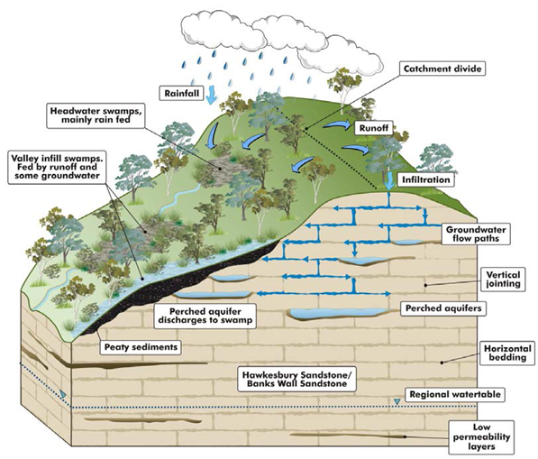
Source: Commonwealth of Australia (2014)
Table 12 shows a summary of properties for the aquifers identified in the southern part of the geological Sydney Basin as well as the confining layers defining aquitards. The information is predominantly from the Southern Coalfields of the geological Sydney Basin, with only limited information from the Western Coalfields. AGL (2013) describes the following as the main confining layers in the Southern Coalfields:
- Ashfield Shale and Mittagong Formation (Middle Triassic), located above the Hawkesbury Sandstone and below the Minchinbury Sandstone, both limiting vertical leakage between alluvial aquifers and deeper sandstone aquifers.
- Bald Hill Claystone, located below the Hawkesbury Sandstone (and Newport and Garie formations) and above the Bulgo Sandstone.
- Stanwell Park Claystone, located below the Bulgo Sandstone and above the Scarborough Sandstone.
- Wombarra Claystone (Lower Triassic to upper Permian), separating the Illawarra Coal Measures (upper Permian) and the Scarborough Sandstone.
It has been suggested that the presence of these confining layers limits the interaction between sequences of shallow alluvial aquifers and deep sedimentary aquifers within the Permian coal measures (see e.g. AGL, 2013 and references therein; Parsons Brinckerhoff, 2013; Bartrop, 2014), thus suggesting some degree of disconnection with shallow aquifers. Other studies (e.g. Jankowski, 2009; Madden and Merrick, 2009; Madden, 2010; SCA, 2012), however, suggest an enhanced degree of vertical connectivity between confining layers and deep stratified sedimentary aquifers due to longwall mining, which is thought could have an impact on surface waters (McNally and Evans, 2007; NSW Government, 2007). Some of the potential impacts are the temporary or permanent loss of surface flow, depletion of overlying aquifers as a result of groundwater drawdown and the migration of gas or tracer elements to other aquifers or surface waters. The degree of connectivity between confining layers (claystones) and the aquifers within porous sandstones is a topic of considerable debate, where the presence of local permeable zones might enhance vertical connectivity (Ward and Kelly, 2013).
The Bald Hill Claystone is a particularly relevant aquitard as it occurs below the main aquifer of the Southern Coalfields, the Hawkesbury Sandstone (see Figure 35). Stammers (2012) and Bradd et al. (2012) suggest that it is generally accepted that the presence of the Bald Hill Claystone limits the exchange of groundwater between the Hawkesbury Sandstone and the underlying Bulgo Sandstone (McKibben and Smith, 2000; NSW Government, 2008), thus possibly providing some protection of potential impacts by coal mining activities.
The main role of these previous aquifers is to support streams through baseflow and groundwater-dependent ecosystems, with both the Hawkesbury and Bulgo sandstone aquifers providing most of the baseflow to surface water courses in the Southern Coalfield (Madden and Merrick, 2009).
Table 12 Hydrogeological properties for main stratigraphic units found in the Southern Coalfields of the geological Sydney Basin
aAshfield Shale
bBulli Coal
Kh = hydraulic conductivity (horizontal); Kv = hydraulic conductivity (vertical); T = transmissivity; TDS = total dissolved solids
Data: AGL (2013); Parsons Brinckerhoff (2013)
In the north-east area of the geological Sydney Basin, the main aquifers are contained in the Quaternary alluvium covering low-lying areas and valleys of surface water courses, and fractured sandstone of the Narrabeen Group. Coal seams act as water-bearing units, typically with poor groundwater quality (reported salinity range 3,330 and 14,300 mg/L TDS, AGL (2013)), and are separated by interburden sediments functioning as aquitards (GHD, 2014). In general, Quaternary alluvium hosts unconfined and laterally discontinuous shallow aquifers. Along the Central Coast, in the north-east area of the geological Sydney Basin but outside the Sydney Basin bioregion, similar aquifers are identified by Molloy et al. (2009): fractured sandstone aquifers, barrier beach sand aquifers and alluvial aquifers. These aquifers are generally of limited extent and consist of clayey and silty materials yielding poor quality groundwater (up to 7000 mg/L TDS) (Molloy et al., 2009).
Fractured Triassic sandstone hosts unconfined perched aquifers as well as semi-confined aquifers separated by relatively impermeable claystone layers, where groundwater flow is dominated by fractures, fissures and bedding in the strata (GHD, 2014). Within the Narrabeen Group, aquifers are hosted by the Terrigal Formation and are unconfined over much of the area north-east of Gosford (Molloy et al., 2009). Bore yields from the Terrigal Formation are reported between 0.5 to 29 L/s with hydraulic conductivities ranging from 0.3 to 50.2 m/d, and salinities in the range of 210 to 6870 mg/L TDS (Molloy et al., 2009). The Patonga Claystone (youngest unit of the Clifton Subgroup) underlies the Terrigal Formation and is considered low yielding with moderate to high salinity. West of Wyong, in the Kulnura-Mangrove Mountain aquifer system, modelling results have reported for the Hawkesbury Sandstone horizontal hydraulic conductivities of 0.01 to 0.5 m/d with transmissivities ranging between 5 and 50 m2/d (Molloy et al., 2009).
In the Blue Mountains, on the Newnes Plateau and in the Southern Highlands, aquifers associated with sensitive ecological areas have a similar conceptual model as the one proposed by Bradd et al. (2012). Shallow aquifers form in higher permeability areas of the Banks Wall and Hawkesbury sandstones and groundwater flow is predominantly horizontal with vertical flow occurring via fissures/fractures that cross-cut bedding (Figure 34). These groundwater systems are associated with highland peat swamps (permanently or sporadically connected to the groundwater system) and are considered to be local groundwater flow systems of typically fresh groundwater, and relatively short flowpaths and residence times (Commonwealth of Australia, 2014).
Danis (2014) summarises the main aquifers in the geological Sydney Basin as: shallow unconfined alluvial aquifers (e.g. Botany Sand Beds), semi-confined fractured Triassic formations (e.g. Hawkesbury Sandstone Aquifer), confined water-bearing units (e.g. Permian coal measures), and fractured basal rocks (e.g. granites and basement rocks).
1.1.4.1.3 Structural features and impact on hydrogeological characteristics
The horizontally layered sandstone strata in the southern part of the geological Sydney Basin, which host the main aquifer systems, show particular features (e.g. dual porosity, fracturing and bedding plane shearing) related to local stress relief effects and large-scale deformation (Russell et al., 2009). Regional scale deformation in the southern part of the geological Sydney Basin created a topographic low known as the Cumberland Basin and surrounding elevated plateaux: Blue Mountains, Hornsby (Lochinvar-Kulnura Ridge), Woronora and Illawarra (Figure 2 4 and Figure 27 in Section 1.1 .3).
A major structural group of north-south trending monoclines and faults in the geological Sydney Basin corresponds to the Lapstone Structural Complex (Figure 27 in Section 1.1. 3), which overlies a deep-seated basement structure (Webb et al., 2009). It forms the frontal ridge of the Blue Mountains Plateau on the western margin of the basin and is indicated by structural lines that extend over 160 km (McLean and Ross, 2009; Webb et al., 2009). The impact of these large-scale features is reflected in improved connectivity and enhanced permeability of overlying aquifers. For example, Russell et al. (2009) suggest that fractures and joints enhance the secondary porosity of sandstone aquifers, improving bore yields in specific areas (e.g. in the Kangaloon Structural Corridor in the Southern Highlands). McLean and Ross (2009) suggest that intense flexural fracturing over the width of the monocline at Leonay has enhanced bore yields compared to the Wallacia drilling site, where the development of the complex is more brittle and is expressed as the Nepean Fault (Webb et al., 2009).
McLean and Ross (2009) suggest the Mittagong horst-graben complex in the upper catchment of the Nepean River has increased the permeability and bore yields in the highly fractured and faulted blocks of the Hawkesbury Sandstone aquifer. Nolan (2009), however, suggests that the increased yields are not due to the presence of fractures associated with the horst-graben structure but to the accessibility (at surface) of a more productive sandstone unit.
In the Kangaloon Structural Corridor (Southern Highlands), fractures and jointing have enhanced recharge and improved bore yields from less than 0.4 ML/day to up to 3.5 ML/day (Russell et al., 2009). Permeabilities for massive sandstone units in the upper catchment of the Nepean River are reported to be two orders of magnitude less than the same fractured strata (Russell et al., 2009).
