Summary
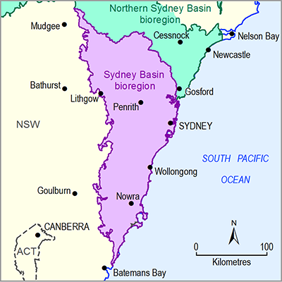
The Sydney Basin bioregion covers an area of about 24,625 km2. It extends along the eastern Australian seaboard from the Hawkesbury River estuary in the north to just south of Durras on the southern NSW coast. Its western boundary is defined by the geological Sydney Basin and its eastern boundary by the Australian coastline. Elevation in the subregion ranges from sea level to 1260 mAHD (metres above Australian Height Datum). Much of the bioregion is characterised by relatively rugged terrain associated with the heavily dissected rock outcrops of the Hawkesbury Sandstone. Inland from Sydney and Nowra and south of Wollongong, the terrain is flatter, reflecting the development of coastal plains from the interactions of rivers with the sea.
The bioregion is characterised by a large area of urban land (14% of the bioregion) and very extensive areas of land used for nature conservation (41%) and other minimal uses (almost 16%). It is one of the most species-diverse of the IBRA regions in Australia and home to a large number of national parks, including the Blue Mountains, Wollemi, Kuring-gai Chase and Royal national parks around Sydney and the linked Morton and Budawang national parks to the south of the bioregion.
Two major river basins drain the bioregion: the Hawkesbury-Nepean river basin, which covers 65% of the bioregion and the Shoalhaven river basin (12% of bioregion) in the south. Other river basins include the eastward-draining streams of the Sydney Coast-Georges River, Wollongong Coast and parts of Clyde River-Jervis Bay basins, and a small part of the west-draining Macquarie-Bogan river basin.
The population of the Sydney Basin bioregion is around five million, concentrated mainly within the area occupied by the Greater Sydney region, with smaller concentrations in Wollongong, Nowra and Southern Highlands towns. Most of the water for these cities and towns is supplied from an integrated water supply network, comprising 21 major storages within the Hawkesbury-Nepean and Shoalhaven river basins, with pipelines to move water between different catchments. This water supply system is managed by WaterNSW. Groundwater use is relatively small component of total use within the bioregion.
The Sydney Basin bioregion has a temperate climate. Mean monthly temperatures for winter are below 10 °C and for summer around 20 °C, but parts of the region are characterised by hot summers, particularly along the coast and at lower elevations. The long-term (1900 to 2012) mean precipitation is 951 mm/year, but there is considerable inter-annual variability. The bioregion does not have a dry season, but the temporal pattern indicates summer dominant rainfall with December to March averaging 90 to 120 mm/month, while July to October averages about 60 mm/month.

