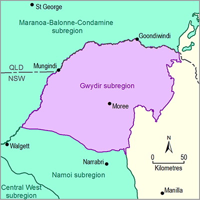
The Gwydir subregion is located within the Murray–Darling Basin (MDB) in northern NSW. It spans an area of 28,109 km2, extending westward from the lower slopes of the New England Tablelands onto the low-lying riverine plains of the Barwon-Darling system. Maximum and minimum elevations for the subregion itself are 1300 mAHD near Mount Kaputar in the south and 110 mAHD near Collarenebri in the west, respectively.
The main rivers draining the subregion are the Gwydir and Macintyre-Barwon rivers. The Macintyre River rises in the region around Inverell (outside the subregion), flows in a north-westerly direction to Boggabilla then continues west to become the Barwon River near Mungindi. The catchment north of the Macintyre River is in the Maranoa-Balonne-Condamine subregion. The lower end of the Macintyre system is characterised by a complex of distributary streams and lagoon systems that flow away from the main channel when certain river levels are reached. The headwaters of the Gwydir River (outside the subregion) lie between Uralla and Guyra in the New England Tablelands. After descending the tablelands and slopes, the westerly flowing Gwydir River fans out into a number of anabranches and effluent channels, which wend their way to the Barwon River and its floodplains. The subregion’s most important water-dependent asset is the Ramsar-listed Gwydir Wetlands on the lower Gwydir and Gingham watercourses, and the Morella Watercourse, Boobera Lagoon and Pungbougal Lagoon on the Macintyre floodplains, which are listed in the Directory of Important Wetlands in Australia (Environment Australia, 2001).
The soils of the subregion are overwhelmingly Vertosols, with some variation in the eastern margins where the topography changes from plains to slopes. The Vertosols are well structured and have a good mix of pores for both transmitting and storing water, so plant growth on these soils is typically very good relative to other soil types and they are agriculturally very valuable. Soil condition of the Gwydir subregion is generally good (NSW DECCW, 2010a). The most limiting land and soil hazards in the subregion are soil structure and soil carbon decline, waterlogging and wind erosion. The majority of land is being used ‘at capability’, meaning the risk of degradation under current land use and management is low (NSW DECCW, 2010b).
The subregion has a heavily modified landscape with very little intact native vegetation cover. Less than 0.4% of land is managed for conservation. The 2010 State of the Catchments report for the Border Rivers-Gwydir region (NSW DECCW, 2010c) rated the vegetation condition as fair and the pressures on land cover as moderate. The main pressures on vegetation extent and condition come from dryland and irrigated agriculture. There are eight endangered ecological communities, protected under the Commonwealth’s Environment Protection and Biodiversity Conservation Act 1999.
The subregion has a mean annual rainfall of 605 mm (1900 to 2011) and is characterised by hot summers and mild winters.
Moree is the major population centre for the subregion with a population of about 7700. Approximately 30% of the employed community work in the agriculture sector (ABS, 2011). The gross value of agricultural production in the Gwydir region in 2010 to 2011 was estimated at $1.43 billion. Regional tourism is also significant, but the reported $784 million in 2011 is from a larger area than the subregion, and perhaps a tenth of this could be attributed to the subregion.

