Input climate data were daily time series of maximum temperature, minimum temperature, incoming solar radiation and precipitation from 1981 to 2012 at 0.05 x 0.05 degree (~5 x 5 km) grid cells from the gridded data originally generated by the Bureau of Meteorology (Dataset 1).
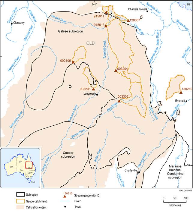
Daily streamflow data from eight gauging sites with unregulated catchments located in and around the Galilee subregion (Figure 10) were used to calibrate the surface water hydrological model.
Criteria for selecting the calibration catchments included that they:
- have long-term measurements (>20 years from 1980)
- are currently not impacted by coal mining or coal seam gas or other major extractive industries
- have no significant flow regulation (e.g. dams)
- are not nested
- are located within or close to the Galilee subregion and have similar catchment sizes and climate regimes.
The catchments of five of the eight gauges are located partly or fully within the Galilee subregion. These are Flinders River at Glendower (915013), Cape River at Pentland (120307), Mills Creek at Oondooroo (002105), Cornish Creek at Bowens Downs (003204) and Alice River at Barcaldine (003302). The catchments of the three remaining gauges (Porcupine Creek at Mount Emu Plain (915011), Darr River at Darr (003205) and Theresa Creek at Valeria (130210)) are located outside but close to the Galilee subregion boundary. Observed daily mean streamflow data for the above gauges were obtained from the Bureau of Meteorology (Dataset 2).
Boundaries for the eight catchments were delineated using the Geofabric (Bureau of Meteorology, Dataset 3).
Data: Bureau of Meteorology (Dataset 3); Bioregional Assessment Programme (Dataset 4, Dataset 5)


