Summary
This section summarises all of the proposals for coal resource development in the Hunter subregion post-December 2012 identified in the mine activity summaries in Section 1.2.2 and Section 1.2.3.
In all 42 post-December 2012 proposals are identified, including 27 proposals to extend existing operations and 15 proposals to initiate new mines. This list will be used as the basis for defining the additional coal resource developments (ACRD) to be modelled in the coal resource development pathway (CRDP) (see product 2.3).
No known coal seam gas (CSG) developments are currently proposed for this subregion.
In this section, information provided in Section 1.2.2 and Section 1.2.3 of this report is used to compile a list of coal mines in the Hunter subregion which have post-December 2012 expansion or new development plans. Table 5 lists 42 proposals, including 27 coal mines with expansion plans and 15 potential new mines. The locations of these coal developments are shown in Figure 10, noting that where a mine has two proposals it is represented by a single point on the map.
The Notes field includes information, obtained from mine environmental impact statements, NSW Government websites and company reports, on whether advice from the Independent Expert Scientific Committee on Coal Seam Gas and Large Coal Mining Development (IESC) has been sought. As at March 2015, some proposals were pre-EIS or awaiting EIS approval, some were approved but not yet commenced and some had commenced.
A map showing lease areas for CSG exploration held by three companies in the Sydney and Gloucester Basin areas is included at the end of Section 1.2.2. These companies are AGL Upstream Investments Pty Limited (AGL Upstream Investments), Dart Energy Limited (Dart Energy), and Santos Ltd. As at March 2015, no there were no coal seam gas proposals in the Hunter subregion.
Table 5 Potential post-December 2012 coal resource developments in the Hunter subregion, as at 10 March 2015.
|
Mine name |
Complex name |
Owner |
Longitude |
Latitude |
Status of EISa |
Notes |
|
Ashton |
Yancoal Australia Ltd |
151.07° |
–32.47° |
EIS for modification 5 – SE open cut submitted November 2009 |
Recommendation made to NSW Planning Assessment Commission August 2011. Maximum permitted production rate of 2.25 million tonnes per annum (Mt/y) (Wells Environmental Services, 2012, p. 4, Table 1) |
|
|
Ashtonb |
Yancoal Australia Ltd |
151.07° |
–32.47° |
EIS approved |
Ashton purchased December 2009. Maximum permitted production rate of 3.2 Mt/y (Wells Environmental Services, 2012, p. 4, Table 1) |
|
|
Austarb |
Yancoal Australia Ltd |
151.31° |
–32.87° |
EIS approved |
Known as Southland Coal Mine from December 2004, previously known as Pelton Colliery and existed for about 100 years. Maximum permitted production rate of 3.6 Mt/y (Umwelt Australia Pty Ltd, 2011, p. 4, Table 1) |
|
|
Bengalla |
Wesfarmers Limited |
150.85° |
–32.27° |
EIS approved |
Extension approved March 2015. IESC advice 24 May 2013. Maximum permitted production rate of 15 Mt/y (Hansen Bailey, 2014b, p. 3, Table 1) |
|
|
Bickhamb |
Bickham Coal |
150.918° |
–31.844° |
Pre-EIS |
Proposed new mine. |
|
|
Bloomfield |
Bloomfield Group |
151.58° |
–32.79° |
EIS approved |
Modification 3 approved February 2013. Maximum permitted production rate of 1.3 Mt/y (Bloomfield Group, 2012) |
|
|
Bulga |
Bulga Coal Complex |
Bulga Coal Management Pty Ltd (Glencore) |
151.11° |
–32.69° |
EIS approved |
IESC advice 10 February 2014. Maximum permitted production rate of 12.2 Mt/y from the open cut operations but not exceeding 20 Mt/y for open cut and underground operations combined (Umwelt Australia Pty Ltd, 2013, p. 12, Table 2.1) |
|
Bylongc |
KEPCO Bylong/Cockatoo |
151.11° |
–32.407° |
EIS by June 2016 |
Two open-cut mines. IESC advice 4 March 2014. Open cut and underground operations have a combined maximum permitted production rate of 6 Mt/y (Hansen Bailey, 2014a, p. 4). |
|
|
Bylongb, c |
KEPCO Bylong/Cockatoo |
151.11° |
–32.407° |
EIS by June 2016 |
Open cut and underground operations have a combined maximum permitted production rate of 6 Mt/y (Hansen Bailey, 2014a, p. 4). |
|
|
Chain Valleyb |
LakeCoal Pty Ltd |
151.55° |
–33.17° |
EIS approved |
Link to Mannering Mine. Maximum permitted production rate increased from 1.2 Mt/y to 1.5 Mt/y in 2013 (EMGA Mitchell McLennan, 2012, p. E.1) |
|
|
Dellworthb, c |
NuCoal Resources Ltd |
151.05° |
–32.42° |
Pre-EIS |
Savoy Hill more likely to proceed than Dellworth |
|
|
Doyles Creekc |
NuCoal Resources Ltd |
150.871° |
–32.51° |
Pre-EIS |
Exploration licence EL 7270 cancelled by NSW Government 31 Jan 2014 |
|
|
Drayton |
Anglo American |
150.91° |
–32.35° |
EIS in preparation |
Mine extension. Director General Requirements issued December 2014. Maximum permitted production rate of 8 Mt/y (Hansen Bailey, 2011, p. 1) |
|
|
Drayton South |
150.83° |
–32.427° |
IESC advice 23 February 2015. Maximum permitted production rate of 6.4 Mt/y (Hansen Bailey, 2015, p. 1) |
|||
|
Ferndaleb, c |
Whitehaven Coal Limited |
150.577° |
–32.469° |
Pre-EIS |
Proposed new mine. |
|
|
Kayugac |
Anglo American |
150.839° |
–32.201° |
Pre-EIS |
Proposed new mine. |
|
|
Liddell |
Mount Owen Complex |
Glencore/Mitsui |
151° |
–32.395° |
EIS approved |
Modification 5 was approved March 2015. IESC advice 10 April 2014. Maximum permitted production rate of 8 Mt/y (SLR, 2013a, p. ii) |
|
Mandalong southern extensionb, c |
Centennial Coal Company Ltd |
151.46° |
–33.12° |
EIS submitted |
Purchased in 2002. Maximum permitted production rate of 6 Mt/y (GSS Environmental, 2013, p. 67) |
|
|
Mangoola |
Glencore |
150.67° |
–32.3° |
EIS approved |
Formally known as Anvil Hill Mine. Maximum permitted production rate of 13.5 Mt/y (EMGA Mitchell McLennan, 2013, p. 23) |
|
|
Manneringb |
Centennial Coal Company Ltd |
151.54° |
–33.17° |
EIS approved |
Link to Chain Valley only. Maximum permitted production rate of 1.1 Mt/y (EMGA Mitchell McLennan, 2014a, p. E.1) |
|
|
Mitchells Flatb, c |
Glencore |
151.314° |
–32.532° |
EIS approved |
Glencore advises in concept phase as at March 2015 |
|
|
Monash |
Yancoal |
151.199° |
–32.773° |
Pre-EIS |
Proposed new mine. |
|
|
Moolarben |
Yancoal Australia Ltd |
149.78° |
–32.29° |
EIS submitted |
IESC advice 1 February 2013. Maximum permitted production rate of 9 Mt/y from Stage 1 and 12 Mt/y from Stage 2 of open cut operations but not exceeding 13 Mt/y for open cut and underground operations combined (Moolarben Coal, 2015, p. 2, Table 1) |
|
|
Moolarbenb |
Yancoal Australia Ltd |
149.78° |
–32.29° |
EIS approved |
Maximum permitted production rate of 4 Mt/y from the underground operations but not exceeding 13 Mt/y for open cut and underground operations combined (Moolarben Coal, 2015, p.2, Table 1) |
|
|
Mount Arthur |
Mount Arthur Coal Mine |
BHP Billiton |
150.87° |
–32.34° |
EIS approved |
Modification 1 – extension of mining approved September 2014. Maximum permitted production rate of 32 Mt/y (BHP Billiton, n.d., p. 3) |
|
Mount Owen |
Mount Owen Complex |
Glencore |
151.1° |
–32.39° |
EIS submitted |
Maximum permitted production rate of 18.5 Mt/y (Umwelt Australia Pty Ltd, 2015, p. 1) |
|
Mount Pennyc |
Cascade Coal |
150.055° |
-32.438° |
Pre-EIS |
Exploration licence EL7406 cancelled by NSW Government 31 Jan 2014. IESC advice submitted Dec 2012. |
|
|
Mount Pleasantc |
Rio Tinto |
150.84° |
–32.237° |
EIS approved |
Modification 1 approved September 2011. IESC advice 24 February 2012. Maximum permitted production rate of 10.5 Mt/y (EMGA Mitchell McLennan Pty Ltd, 2010, p. 1) |
|
|
Mount Thorley-Warkworth |
Mount Thorley-Warkworth |
151.09° |
–32.641° |
IESC advice 29 June 2012. Maximum permitted production rate of 10 Mt/y (EMGA Mitchell McLennan, 2014b) |
||
|
Muswellbrook No 2 |
Muswellbrook Coal Mine |
Idemitsu Kosan Ltd |
150.941° |
–32.248° |
Maximum permitted production rate of 2 Mt/y (Muswellbrook Coal Company Limited, 2014,p. 1) |
|
|
Muswellbrook Westc |
Muswellbrook Coal Mine |
Idemitsu Kosan Ltd |
150.772° |
–32.215° |
Referred to IESC 2015 |
|
|
Myunab |
Centennial Coal Company Ltd |
151.57° |
–33.06° |
EIS approved |
Maximum permitted production rate increased from 2 Mt/y to 3 Mt/y in 2014 (Centennial Coal, 2014, p.26, Table 4) |
|
|
Newstan |
Centennial Coal Company Ltd |
151.577° |
–32.976° |
Pre-EIS |
Two new proposals, but as at April 2015 in care and maintenance. Maximum permitted production rate of 4 Mt/y (SLR, 2013b, p. 20) |
|
|
Ravensworth Eastb |
Ravensworth Complex (Underground) |
Resource Pacific Pty Limited (owned by Glencore and Marubeni) and Posco |
151.04° |
–32.44° |
EIS approved |
Modification 9 – changes to longwall layout approved June 2013. No additional mining. Maximum permitted production rate of 7 Mt/y (GSS Environmental, 2012, p.12) |
|
Rix's Creek |
Bloomfield Group |
151.13° |
–32.58° |
EIS in preparation |
Maximum permitted production rate of 2.5 Mt/y (AECOM Australia Pty Ltd, 2013, p. 1) |
|
|
Savoy Hillc |
NuCoal Resources Ltd |
150.9° |
–32.4° |
Exploration phase |
||
|
Spur Hillb, c |
Malabar Coal Ltd |
150.77° |
–32.41° |
EIS submitted |
Pending approval. IESC advice 10 February 2014. Maximum permitted production rate of 8 Mt/y (Spur Hill Underground Coking Coal, 2014, p. 3) |
|
|
Ulanb |
Glencore |
149.75° |
–32.215° |
EIS approved |
Production began in May 2014.from Ulan West underground longwall mine. |
|
|
Wallarah 2b, c |
Wyong Coal Pty Ltd |
151.388° |
–33.235° |
EIS submitted |
Pending approval. IESC advice 24 May 2013. Maximum permitted production rate of 5.0 Mt/y (Hansen Bailey, 2013, p. 4) |
|
|
Wambo |
Wambo Coal Company Ltd |
151° |
–32.58° |
EIS in preparation |
Maximum permitted production rate of 8 Mt/y from the open cut operations but not exceeding 14.7 Mt/y for open cut and underground operations combined (Peabody Energy, 2014, p.4, Table 1) |
|
|
Wambob |
Wambo Coal Company Ltd |
151° |
–32.58° |
EIS in preparation |
Maximum permitted production rate of 7.5 Mt/y from the underground operations but not exceeding 14.7 Mt/y for open cut and underground operations combined (Peabody Energy, 2014, p.4, Table 1) |
|
|
Wilpinjong |
Wilpinjong Coal Pty Ltd |
149.89° |
–32.33° |
EIS in preparation |
Maximum permitted production rate of 16 Mt/y (Peabody Energy, n.d., p. 9, Table 1) |
aThe status of the project within an environmental impact statement (EIS): pre-EIS, EIS in preparation, EIS submitted, EIS closed, supplementary EIS and EIS approved
bUnderground mine
cNew mine
IESC = Independent Expert Scientific Committee on Coal Seam Gas and Large Coal Mining Development
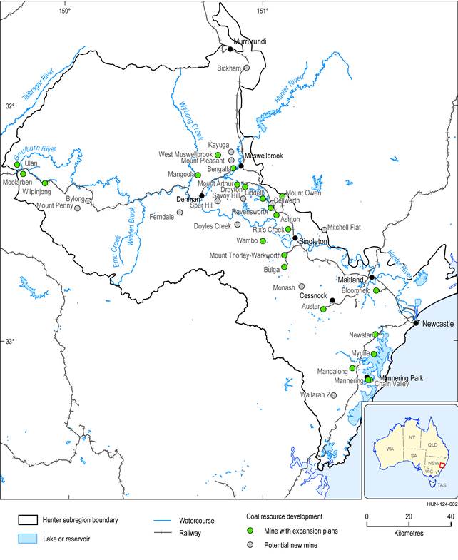
West Muswellbrook Coal Mine is a potential new mine and not a currently existing mine as shown on the figure.
Data: Bioregional Assessment Programme (Dataset 1)
