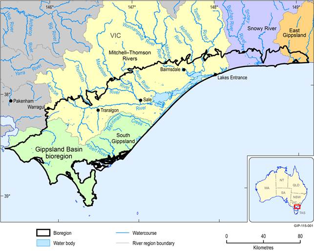
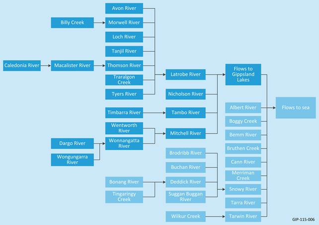
The surface water management units defined in this section conform to the major river regions delineated in the Bureau of Meteorology Geofabric dataset (Bureau of Meteorology, 2013). According to Bureau of Meteorology’s Geofabric data, the surface water systems in the Gippsland Basin bioregion are part of four river regions in the state of Victoria. These are South Gippsland, Mitchell–Thomson, Snowy and East Gippsland as shown in Figure 33. The major watercourses within these river regions and their topological relationships with each other are presented in Figure 34. Details of each of these four river regions are presented in the following sections.
1.1.5.1.1 South Gippsland River Region
The South Gippsland River Region is located in the south-west of the Gippsland Basin bioregion. It has a drainage area of 6202 km2. The major surface water systems include the Albert, Tarra and Tarwin rivers and Merriman and Bruthen creeks, as well as freshwater and salinewater wetlands (Figure 35). A notable feature of the system is its floodplain providing rich, agricultural land as well as areas of high conservation value, such as Wilsons Promontory, Corner Inlet and the Nooramunga Marine and Coastal Park. About 92% of the river region area is included in the Gippsland Basin bioregion and makes up 39% of the bioregion.
The majority of watercourses in this river region originate within the Gippsland Basin bioregion and discharge to inlets (e.g. Anderson, Corner) through to the ocean. The majority of the watercourses in the South Gippsland River Region are unregulated; only Coalition and Lance creeks in the western part of the river region are regulated. Almost three-quarters (74%) of the streams in the South Gippsland River Region are in moderate condition. Of the remainder, 10% are in good condition, 10% are in poor condition and 5% are in very poor condition (Department of Environment and Primary Industries, 2013a). There have been a number of significant flood events in the South Gippsland River Region including in 1934, 1990, 2011 and 2012. Often short duration and high intensity rainfall causes flash flooding throughout the South Gippsland River Region. Moderate to heavy rainfall, coupled with a high or incoming tide or storm surge associated with an extreme low pressure system can exacerbate flooding in the coastal areas.
Streamflow in the South Gippsland River Region has not yet been affected much by diversion of water. There are no large regulated supply systems and irrigation is not widespread due to the relatively reliable rainfall. However, there are some storages and pump stations of small to medium capacity across the river region.

Data: Bioregional Assessment Programme (Dataset 1), Department of Environment and Primary Industries (Dataset 2), Geoscience Australia (Dataset 3), Bureau of Meteorology (Dataset 4)
1.1.5.1.2 Mitchell–Thomson River Region
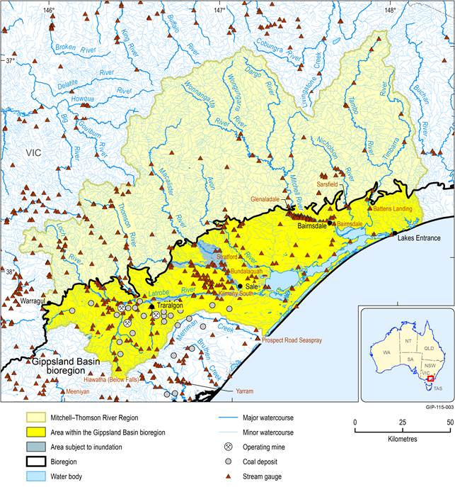
The Mitchell–Thomson River Region covers the central part of Gippsland Basin bioregion. It has a combined drainage area of 21,091 km2. Several large rivers including the Latrobe, Thomson, Mitchell, Tambo and Nicholson rivers are part of this river region. The surface water systems also include several creeks and wetlands (Figure 36). In the north, the river region is characterised by the naturally forested Eastern Highlands. The lower part of the river region features cleared agricultural land and flow to Gippsland Lakes in the east. The Latrobe, Thomson, Macalister, Avon, Mitchell, Nicholson and Tambo rivers all flow into the Gippsland Lakes through a varied landscape which includes open-cut coal mines, power generation plants, timber harvesting and paper production, major water storages, Ramsar wetlands and agricultural pursuits including irrigation, horticulture and grazing. Although much of the land has been cleared for agriculture, there are significant mining activities for brown coal used at Loy Yang, Hazelwood and Yallourn power stations. About 36% of the river region area is included in the Gippsland Basin bioregion and this makes up 52% of the bioregion area.
All the major watercourses in the Mitchell–Thomson River Region originate outside the Gippsland Basin bioregion and discharge to the Gippsland Lake (Figure 36). The majority of them are unregulated except for the lower parts of the Latrobe, Thomson and Nicholson rivers. The amount of flow regulation on most of these systems is however relatively small. The hydrological condition of streams across the catchment reflects the varied land use - from natural and near natural flow regimes in headwater streams in forested areas of the region to flow regimes under immense stress in areas dependent on water supply for domestic and agricultural use. One-third (34%) of the streams in the Latrobe river basin are in good or excellent condition, with a further 44% in moderate condition. Over half (55%) of the streams in the Thomson river basin are in good or excellent condition and about 41% are in moderate condition (Department of Environment and Primary Industries, 2013a). There have been a number of large flood events in the Mitchell–Thomson River Region including in 1964, 1970, 1983, 1991, 2007, 2011 and 2012. These events have caused significant infrastructure and property damage in the past.
Flow in the Mitchell–Thomson River Region has been affected by dams and diversion of water. There is a large dam on the Thomson River (1068 GL capacity), a small dam on Nicholson River (640 GL capacity), and two small reservoirs (Department of Environment and Primary Industries, 2014a). A large proportion of available surface water in this basin is allocated for the environment with the remainder allocated through bulk entitlement and licensed diversions.
Data: Bioregional Assessment Programme (Dataset 1), Department of Environment and Primary Industries (Dataset 2), Geoscience Australia (Dataset 3), Bureau of Meteorology (Dataset 4)
1.1.5.1.3 Snowy River Region
The Snowy River Region covers a small proportion of the Gippsland Basin bioregion in the east. It has a drainage area of 15,767 km2. The surface water systems include the Eucumbene, Delegate and Jacobs rivers in the upper river region and Deddick, Buchan and Brodribb rivers in the downstream part of the river region, as well as wetlands on the floodplain (Figure 37). In the north, the river region is characterised by the naturally forested Eastern Highlands. About 6% of the river region area is included in the Gippsland Basin bioregion and makes up about 7% of the bioregion area.
The Snowy River is one of the major watercourses in south-eastern Australia. It originates on the slopes of Mount Kosciuszko, draining the eastern slopes of the Snowy Mountains in NSW, before flowing through the Alpine National Park and the Snowy River National Park in Victoria and emptying into Bass Strait. Major watercourses in this river region originate outside the Gippsland Basin bioregion and discharge to the mouth of the Snowy River through to the sea. The watercourses in this river region are unregulated except for the Snowy River. The hydrological conditions of streams across the catchment reflect from natural and near natural flow regimes in headwater streams in forested areas of the region to flow regimes under immense stress in areas dependent on water supply for domestic and agricultural usage (Department of Environment and Primary Industries, 2013a). There have been a number of significant flood events in the Snowy River Region including in 1971, 1978, 1988, 2007, 2011 and 2012 (Department of Environment and Primary Industries, 2012).
Streamflow in the Snowy River Region has been affected by large dams and diversions. Flow was greatly reduced in the mid-20th century after the construction of four large dams at Guthega, Island Bend, Eucumbene and Jindabyne and many smaller diversion structures in its headwaters in NSW, as part of the Snowy Mountains Scheme (Department of Environment and Primary Industries, 2014a).

Data: Bioregional Assessment Programme (Dataset 1), Bureau of Meteorology (Dataset 4)
1.1.5.1.4 East Gippsland River Region
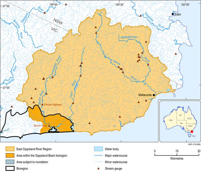
The East Gippsland River Region is located in the eastern end of the Gippsland Basin bioregion. It is a relatively small river region compared to other river regions in Gippsland and it covers only a small proportion of the Gippsland Basin bioregion. It has a drainage area of 5670 km2. The surface water system includes four large rivers and several creeks, as well as freshwater and salinewater wetlands (Figure 38). The Bemm River is listed as a Heritage River for the presence of rainforest, significant habitat, native fish diversity and the connection to Sydenham Inlet. The Upper Genoa River is also listed as a Heritage River based on the geological/geomorphological significance of the Genoa River gorge, scenic landscapes and sites of botanical significance. About 5% of the river region area is included in the Gippsland Basin bioregion and makes up about 2% of the bioregion area.
The main rivers in the East Gippsland River Region are the Bemm, Cann and Genoa rivers, all of which flow south or south-east into coastal inlets or lagoons, before entering the sea. Only the Bemm and Cann rivers flow to the Gippsland Basin bioregion. The watercourses in this river region are unregulated except for some small diversion weirs. The hydrological condition of streams varies across the East Gippsland River Region. Consistent with the high proportion of naturally forested land and the absence of major water storages, most streams in this river region maintain natural or near natural flow regimes (Department of Environment and Primary Industries, 2013a). There have been a number of large flood events in the East Gippsland River Region. The most recent major flood events occurred in the region in 1990, 1998 and 2007. A number of lesser floods also occurred through this period, including those in 2010 and 2011.
Data: Bioregional Assessment Programme (Dataset 1), Bureau of Meteorology (Dataset 4)
