Within the Gippsland Basin there are three major stratigraphic groups: the Early Cretaceous Strzelecki Group, the Late Cretaceous to Eocene Latrobe Group and the Oligocene to Pliocene Seaspray Group. Deposition of each of these groups was preceded by a major tectonic event resulting in erosional unconformities that define the base of each group and are presumed to be continuous across the basin (Bernecker et al., 2003).
The Gippsland Basin has a complex stratigraphy as shown in Figure 20 with lithological variation evident across the structural elements of the basin. Detailed descriptions of the stratigraphic units of the Gippsland Basin can be found in Cupper et al. (2003), Duddy (2003), Goldie Divko et al. (2009), Holdgate (2003) and Holdgate and Gallagher (2003). A summary of the stratigraphy from oldest to youngest is provided herein, focusing on the stratigraphic units of the onshore portion of the basin in the Latrobe Valley and Seaspray Depression.
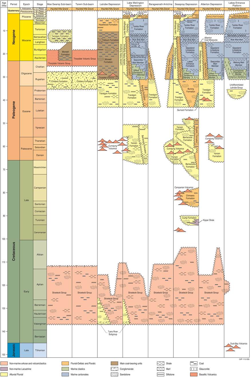
Figure 20 Gippsland Basin onshore stratigraphy
Source: Adapted from Goldie Divko et al. (2009), drawing on information from Pratt (1985), Brumley and Holdgate (1983)
Note: This figure has been optimised for printing on A3 paper (297 mm x 420 mm)
1.1.3.2.1 Strzelecki Group
The Strzelecki Group consists of non-marine Lower Cretaceous sedimentary rocks. The Strzelecki Group outcrops extensively in the South Gippsland highlands and along coastal sections between San Remo and Inverloch in South Gippsland.
Tyers River Subgroup and undifferentiated Lower Strzelecki Group
The Tyers River Subgroup outcrops in the Tyers River – Boola Boola Forest area in Gippsland Basin (formerly Tyers Group of Philip (1958)). Onshore, the Tyers River Subgroup occurs within the Latrobe Valley Depression and the Lake Wellington Depression (Goldie Divko et al., 2009).
The Tyers River Subgroup was deposited in fluvial environments grading from proximal alluvial fans of the Tyers Conglomerate to more distal fan and fluvial environments, including braided stream channels (Tosolini et al., 1999). The sediments are thought to consist of detritus largely derived from local erosion of adjacent Paleozoic rock. The basal Tyers Conglomerate is characterised by conglomerate beds with interbedded pebbly sandstone layers and rare siltstone and shale. The Locmany Member consists of upwards-fining sequences grading from a conglomeratic base through fine to medium-grained sandstone, siltstone, and in places with thin coal seams towards the top. The Exalt Member gradationally overlies the Locmany Member and is mainly an upward coarsening sandstone (Tosolini et al., 1999).
The Tyers River Subgroup is thought to correlate with a 5 km thick sequence of undifferentiated Lower Strzelecki Group rocks identified from seismic surveys in the main offshore depocentres (Duddy, 2003).
Undifferentiated Upper Strzelecki Group
Lower Cretaceous sedimentary rocks referred to as the Upper Strzelecki Group outcrop extensively in the Strzelecki Ranges. The Upper Strzelecki Group is considered to both overlie and intertongue with the Tyers River Subgroup. The sediments were originally deposited in fluvial environments dominated by internally braided channels flowing through extensive floodplains with marginal alluvial fans. Rapid subsidence led to accumulation of multi-storied channel complexes, with numerous erosion surfaces (Duddy, 2003). The sediments were mainly reworked tuffaceous material from rift-related explosive volcanism roughly contemporaneous with deposition, as well as some detritus from nearby outcropping Paleozoic rocks. The sequence exceeds 3 km in thickness and covers at least 30,000 km2(Duddy, 2003).
The Upper Strzelecki Group rocks are relatively uniform, consisting of a generally upwards-fining sequence of massive coarse- to fine-grained sandstone. These interfinger with a range of minor rock types including siltstone, fine-grained sandstone, paleosoils, coal seams and lacustrine shale.
In the Tarwin sub-basin, the Strzelecki Group is alternatively called the Wonthaggi Formation which bears black coal deposits that were an important coal resource in the early history of Victorian coal development.
1.1.3.2.2 Latrobe Group
Strzelecki Group deposition terminated abruptly at the end of the Albian (around 100 Ma) by significant localised uplift and erosion of Paleozoic basement at the basin margins and partial basin inversion. This formed the Otway Unconformity. Where fully developed, the unconformity separates deeply eroded Strzelecki Group rocks or Paleozoic basement from the overlying Latrobe Group (Duddy, 2003).
There are four subgroups within the Latrobe Group, each of which is bound by basin-wide unconformities. Formations in each subgroup are distinguished according to their main depositional facies assemblages (Bernecker et al., 2003).
Emperor Subgroup
The Emperor Subgroup (Bernecker and Partridge, 2001) is generally restricted to the offshore part of the basin. Onshore, the Emperor Subgroup occurs only in the Seaspray Depression. It was originally deposited in lacustrine and fluvial environments and comprises sandstone and minor lacustrine mudstone formed during the Turonian (around 94 to 90 Ma). The Emperor Subgroup has only been intersected in drill-holes around the basin margins near bounding faults of the Northern and Southern terraces.
The Emperor Subgroup is separated from the overlying Golden Beach Subgroup by the Longtom Unconformity, a sedimentary hiatus of about 3 million years duration (from around 89 Ma).
Golden Beach Subgroup
The Golden Beach Subgroup was deposited around 87 to 73 Ma (Duddy, 2003). Onshore, the Golden Beach Formation occurs only in the Seaspray Depression, where it is represented by the fluvial-deltaic Chimaera Formation (Bernecker and Partridge, 2001). The Chimaera Formation comprises coarse-grained sediments as well as fine-grained floodplain deposits including some coal and can exceed 300 m in thickness (Bernecker et al., 2003). Offshore, the Golden Beach Subgroup also contains several basaltic lava flows, scoria cones and ring-dyke intrusions (Duddy, 2003). These volcanics terminate the Golden Beach Subgroup and signal a depositional hiatus of about 2 million years represented by the Seahorse Unconformity.
Halibut Subgroup, Yarram Formation and Carrajung Volcanic Group
The Halibut Subgroup was deposited between 75 to 45 Ma. Halibut Subgroup sediments document the changes from non-marine to marine environments in a west-east, or onshore-offshore direction (Bernecker et al., 2003). Two formations are identified within the onshore part of the Gippsland Basin: the Barracouta Formation (identified in the Seaspray Depression and the Lake Wellington Depression) and the Kingfish Formation, identified in the Seaspray Depression (Bernecker and Partridge, 2005). The Barracouta Formation was deposited on an upper coastal plain and is characterised by fluvial siltstone, sandstone and minor coal. The Kingfish Formation was deposited on a lower coastal plain and sandstone, siltstone and coal were deposited in fluvial-deltaic and paralic settings (landward side of the coast).
The Yarram Formation is equivalent to the Halibut Subgroup in age. It is comprised of a sequence of fluvial/alluvial conglomerates, sandstones, thin coal and shale. The Yarram Formation occurs within the Lake Wellington Depression, Seaspray Depression and Alberton Depression.
The Carrajung Volcanic Group has been dated as 57 to 55 Ma and is comprised of tuff and basalt that can be over 100 m thick (Holdgate and Gallagher, 2003). The Carrajung Volcanic Group has been identified in the Latrobe Valley Depression, Lake Wellington Depression, Seaspray Depression and Alberton Depression.
Cobia Subgroup, Traralgon Formation and undifferentiated Latrobe Group
The Cobia Subgroup is represented onshore by the Burong Formation and the Gurnard Formation. The Burong Formation is also called the Traralgon Formation. In the coal literature, the Traralgon Formation is the name used and so the rest of this report will use Traralgon Formation. The Gurnard Formation is identified within the Seaspray Depression. The Gurnard Formation consists of fine- to medium-grained glauconitic siliciclastic rocks deposited in a shallow to open marine environment during the early Oligocene to middle Eocene.
The Traralgon Formation of the Latrobe Valley Depression, Lake Wellington Depression, Seaspray Depression and the Alberton Depression, and the undifferentiated Latrobe Group of the Lakes Entrance Platform, are age equivalents of the Cobia Subgroup. The Traralgon Formation is absent from the Moe Swamp and Tarwin sub-basins.
The Traralgon Formation is early Eocene to early Oligocene in age and was deposited in alluvial-fluvial environments. The Traralgon Formation comprises coals with interbedded gravels, sands and clays. The formation primarily comprises sands and gravels towards its base, coal seams and clays in its middle sequence, and sand, clay and minor coal in the upper sequence. The formation has been subdivided into the T1 (upper) and T2 (lower) coal seams and interseams (Holdgate et al., 2000). In the Seaspray Depression, the T2 interseam is called the Yarram Formation (Nicol, 2010).
Deposition of the Cobia Subgroup ceased during the early Oligocene. This break in sediment deposition is known as the Latrobe Unconformity (Bernecker et al., 2003).
1.1.3.2.3 Seaspray Group
The Seaspray Group and the main coal-bearing units of the Latrobe Valley Subgroup began to form during the early Oligocene. By the Oligocene, most of the basin had become marine in character. Exceptions to this occur in the Latrobe Valley, Baragwanath Anticline and Alberton Depression where non-marine Morwell and Yallourn Formation coal sequences continued to accumulate behind sand barrier systems (Balook Formation) (Holdgate et al., 2000). The Latrobe Valley Subgroup coal-bearing formations are a non-marine facies equivalent to the Seaspray Group further east (Holdgate and Gallagher, 2003).
Within the Latrobe Valley Depression, the Morwell Formation, Yallourn Formation and Hazelwood Formation are grouped together as the Latrobe Valley Group.
Across the onshore part of the basin the following trend from non-marine to marine sediments is evident:
- In the east (near Orbost) and the south, the system is dominated by marine rocks, limestones and marls of the Seaspray Group.
- Heading west and north, towards the Latrobe Valley Depression, the sandstone of the Balook Formation (deposited as barrier sands) dominates the system.
- Heading further west and north into the Latrobe Valley Depression, alluvial and fluvial sediments, sandstones, coal, siltstones and shales dominate.
Lakes Entrance Formation
The Lakes Entrance Formation comprises the earliest fully marine sediments in the onshore Gippsland Basin and was deposited during the late Oligocene and early Miocene (Holdgate and Gallagher, 2003; Thompson and Walker, 1982). Onshore, the Lakes Entrance Formation includes the Giffard Sandstone Member, Cunningham Greensand Member, Metung Marl Member and the Seacombe Marl Member (Hocking, 1976a). The formation continues offshore where it is considered an important regional seal over most of the oil and gas fields, reaching a maximum thickness of 500 m (Holdgate and Gallagher, 2003).
Gippsland Limestone
The increasing dominance of marine conditions during the late Oligocene and early Miocene resulted in the deposition of marl and shelf carbonates. The Gippsland Limestone of early Miocene age was deposited in cold water at mid- to outer-shelf depths and consists of a thick sequence of carbonates that overlies the Lakes Entrance Formation both onshore and offshore (Holdgate and Gallagher, 2003). The Gippsland Limestone has maximum thickness of around 240 m in the eastern part of the Lake Wellington Depression.
Wuk Wuk Marl
The Wuk Wuk Marl was deposited in the middle Miocene into a high-productivity, upwelling, warmer water environment. It overlies the Gippsland Limestone east of the Baragwanath Anticline (Holdgate and Gallagher, 2003).
Balook Formation
The Balook Formation formed in a depositional transition zone, between the mostly terrestrial sequence in the west and north, and the marine sequence in the south and east. The formation is a barrier sand sequence and lies immediately inland of the Seaspray Group. It consists of about 400 m of fine- to medium-grained sand with minor interspersed clayey and lignitic horizons (Thompson and Walker, 1982). The formation extends north-north-east for 150 km across the Seaspray and Lake Wellington depressions. However, it is not present across the Baragwanath Anticline and associated structures (Nicol, 2010). The Balook Formation formed the coastal barrier behind which the coals of the Latrobe Valley Subgroup accumulated and includes all the transgressive sand beds in the Latrobe Valley Coal Measures (Holdgate and Gallagher, 2003).
Bairnsdale Limestone
The Bairnsdale Limestone overlies the Wuk Wuk Marl. It was deposited in the middle Miocene. It is a relatively thin unit with a maximum thickness of about 25 m (Holdgate et al., 2003), consisting of marl and calcarenite (Geoscience Australia, 2012).
Tambo River Formation
The Tambo River Formation comprises strandplain sediments of glauconitic sandy coquina limestone deposited in the middle Miocene. It conformably overlies the Bairnsdale Limestone (Holdgate and Gallagher, 2003), and is a regressive sequence representing transition between the Bairnsdale Limestone and the Jemmys Point Formation. The subsurface thickness averages 33 m in the Seaspray Depression and is up to 100 m in the western part of the Lake Wellington Depression (Abele, 1988). The maximum thickness is 300 m (Geoscience Australia, 2012).
Lake Wellington Formation
The middle Miocene marine regression resulted in deposition of the Lake Wellington Formation, deposited as lacustrine facies up to 90 m thick in locally depressed areas within the Seaspray and Lake Wellington depressions. The formation is described as fine uniform silty sand which exhibits rhythmic bedding or coarser non-calcareous sands (Thompson and Walker, 1982).
Jemmys Point Formation
The Jemmys Point Formation was deposited as the result of a relatively short lived marine transgression during the early Pliocene. It is subdivided into three members: the (lower) Tarraville Member which is up to 20 m thick and consists of dark lagoonal bioturbated muds and clays, the (upper) Tarraville Member which is up to 100 m thick and consists of fine to medium-grained quartz sands, and the Woranga Member which consists of a thin marly limestone to shelly sand (Thompson and Walker, 1982).
Thorpdale Volcanic Group
The basaltic Thorpdale Volcanic Group outcrops extensively in the South Gippsland highlands and has a maximum thickness of around 60 m over the Narracan, Warragul and western Balook Blocks (Holdgate and Gallagher, 2003). Volcanism occurred from the Eocene to the Miocene (49 to 22 Ma) (Australian Stratigraphic Units Database, 2012). Basaltic sills extend from the major eruptive centres and locally interbed and underlie the Morwell Formation within the Latrobe Valley Depression.
Morwell Formation
The Morwell Formation is a complex unit of thick coal seams and lesser clay and sand that disconformably overlies the Traralgon Formation in the Latrobe Valley Depression, deposited during the Oligocene and early Miocene (Holdgate, 2003). The Morwell Formation, together with the similar-aged Alberton Formation (located in the Alberton Depression, south of the Baragwanath Anticline) are confined to the part of the Gippsland Basin that is west of the Balook Formation, the sand barrier that marks the predominant maximum point of marine transgression for the Seaspray Group. The Morwell Formation extends across the Latrobe Valley Depression and grades into the Thorpdale Volcanic Group in the Moe Swamp sub-basin and on the Narracan Block. The lateral marine equivalents of the Morwell and Yallourn formations are the Lakes Entrance Formation and Gippsland Limestone.
The Morwell Formation has been subdivided into several coal seam and interseam units, namely, the M2C, M2B, M2A, M1B and M1A coals and interseam sediments (listed from oldest to youngest). The formation is locally interbedded with and underlain by the Thorpdale Volcanic Group. The Childers formation, in the Moe Swamp and Tarwin sub-basins, is equivalent to the Lower Morwell Formation (M2) of the Latrobe Valley.
Yallourn Formation
The Yallourn Formation was deposited in the middle Miocene. It consists mainly of the Yallourn Coal Seam (and its subseams Y1–Y4) and conformably overlies the Morwell Formation. In the Latrobe Valley, the Yallourn and Morwell coal seams are separated by the Yallourn Clay which is up to 5 m thick (Holdgate, 2003). Similar to the Morwell Formation, the Yallourn Formation grades laterally eastwards into the Balook Formation. In the adjacent Moe Swamp sub-basin to the west, an isolated coal-bearing sequence of equivalent age to the Yallourn Formation is known as the Yarragon Formation. The Yallourn Formation is absent from the Tarwin sub-basin.
The Yallourn Coal Seam has been subsequently modified by late Miocene erosion to a greater extent than the coal seams of the Morwell Formation.
Hazelwood Formation
The non-marine Hazelwood Formation was deposited during the late Miocene. This is a clay-rich coaly unit up to 200 m thick, predominantly within the Traralgon and Latrobe synclines in the Latrobe Valley Depression (Holdgate, 2003). The Hazelwood Formation grades into the marine Lake Wellington Formation, Tambo River Formation and Bairnsdale Limestone.
1.1.3.2.4 Sale Group
The Sale Group consists of marine to non-marine sediments deposited during the Pliocene to Pleistocene.
Boisdale Formation
The Boisdale Formation unconformably overlies the Lake Wellington Formation and is found from east of Rosedale to the Lakes Entrance area, and in the onshore Seaspray Depression (Nicol, 2010). It is a terrestrial (fluviatile) sequence that primarily comprises sand, silt and clay. It has been divided into two sub-units, namely the (lower) Wurruk Sand Member and the (upper) Nuntin Clay Member. Along the coastline, the formation transitions into and partly overlies its marine equivalent, the Jemmys Point Formation. The Boisdale Formation was deposited during the late Miocene to early Pliocene (HydroTechnology, 1994; Nicol, 2010).
Haunted Hills Gravel
A major marine regression during the Pliocene resulted in deposition of river gravels and alluvium known as the Haunted Hills Gravel (Holdgate and Gallagher, 2003; Thompson and Walker, 1982). The formation has a wide range of particle sizes, generally poor sorting, variable bedding, and widespread lensing with numerous local erosional breaks. The Haunted Hills Gravel consists of sand, gravel and clay with a maximum thickness of around 30 m (Abele, 1988).
1.1.3.2.5 Quaternary
Quaternary depositional environments in the Gippsland Basin are significantly different from those of the Paleogene and Neogene carbonate, siliciclastic and lignitic sedimentation (Cupper et al., 2003). Quaternary sediments are mostly undifferentiated and unconsolidated alluvium restricted to the floodplains of the main waterways and drainage features. Minor lacustrine, swamp and dune sand deposits also occur. The Quaternary sediments generally form a thin cover over the Haunted Hills Gravel. In some areas there are thicker Quaternary sediments where paleochannels of the present-day Snowy, Nicholson/Tambo, Mitchell, Avon/Perry and Thompson/Macalister/ Merrimans Rivers, and Ironstone Creek deposited sand, gravel, clay and silt during glacial lowstands of the early to middle Pleistocene (Cupper et al., 2003).
