Summary
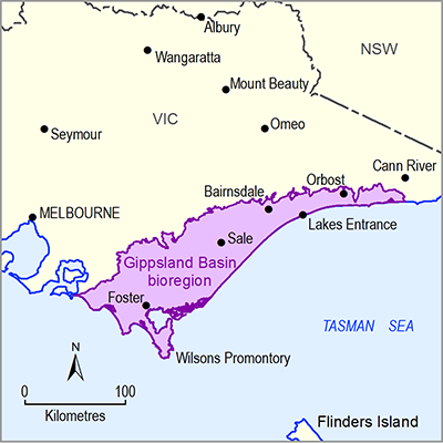
The Gippsland Basin bioregion is situated in south-eastern Victoria and covers an area of approximately 14,636 km2. The bioregion includes the area between the foothills of the Great Dividing Range to the north, and the Bass Strait coast to the south, Warragul to the west, and the Cann River to the east. The elevation of the bioregion ranges from sea level to 750 m at Mount Tassie within the Strzelecki Ranges.
The soil types of the Gippsland Basin bioregion generally align with the broad landscape features, the underlying geology and physical location. Eleven soils types are represented across the bioregion, with over 50% of the area covered by Sodosols and Dermosols. Much of the soil in the Gippsland Basin bioregion is nutrient depleted due its age and natural weathering. Additionally, soil has been further depleted in some areas from extensive grazing and agriculture over a long period of time causing compaction and erosion of the fertile upper soil horizon. Despite this, the use of fertilisers and irrigation has enabled the region to become highly productive for crops, farming and forestry.
The economy of Gippsland is primarily based on agriculture, forestry, dairy and mining with a gross regional product estimated at $13.26 billion. The Gippsland region contributes over 20% of national milk production. In particular, the Macalister Irrigation District is a key dairy, agriculture and forestry area and covers approximately 530 km2 between Sale and Lake Glenmaggie following the Macalister and Thomson river valleys.
Approximately 90% of Victorian power is generated from three power stations within the bioregion at Yallourn, Hazelwood and Loy Yang, with coal sourced from the Latrobe Valley. It is estimated that 430 Bt of brown coal remain in situ in the Latrobe Valley, with 33 Bt of economic resource. In addition, conventional oil and gas from the Gippsland Basin contributes approximately 20% of Australia’s production.
There are four major water storage locations within the Gippsland Basin bioregion: Lake Glenmaggie, Cowwarr Weir, Blue Rock Dam and Lake Narracan. The Thomson Reservoir is situated north of the bioregion and is the largest water storage in Melbourne’s water supply.
The bioregion covers six Victorian local government areas, although none are fully included within the bioregion. The overall population of the Gippsland Basin bioregion has been estimated at 203,445 based on the population counts of the 2011 Australian Bureau of Statistics census. The population is dispersed throughout the region, with over 40% of the population residing in towns with less than 1000 people. Although there are no major cities falling within the Assessment area, there are six population centres in the bioregion which have a population of over 10,000.
The climate across the Gippsland Basin bioregion is temperate and is influenced by the geography, topography, elevation and distance from the coast. The mean long-term annual precipitation across the bioregion is 835 mm, although this is variable across the bioregion. The Gippsland plains receive on average 500 to 700 mm rainfall annually, with the higher peaks of the Strzelecki Ranges and Wilsons Promontory receiving up to 2000 m rainfall annually. The region experiences summers with mean maximum temperatures around 24°C and mean minimums of around 13°C. Winter temperatures range from 5°C to 14°C.
Projected future climate outcomes for the catchments in the bioregion have been determined through the South Eastern Australian Climate Initiative study. The study performed modelling analysis on 15 global climate models and daily rainfall and areal potential evapotranspiration statistics from 1895 to 2008 under scenarios of 1 and 2 degrees of warming. In all warming scenarios it is predicted that the annual rainfall and runoff will reduce compared to the historical mean.

