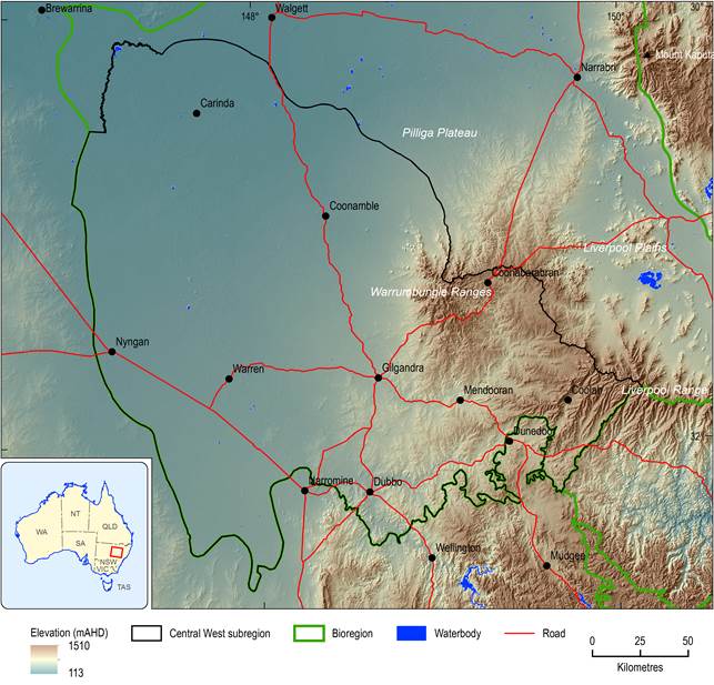
The Central West subregion of the Northern Inland Catchments bioregion is located within the Murray–Darling Basin (MDB) in central NSW. To the north, it is bounded by the Namoi subregion and a small section of the Maranoa-Balonne-Condamine subregion to the north-west. It abuts the Hunter subregion to the east (Figure 3). The southern and western boundaries of the subregion correspond to the aquifer extents of the Oxley Basin, Great Artesian Basin, Great Artesian Basin Alluvial and Lower Macquarie Alluvium groundwater management areas, which is as far as the coal-bearing geology extends.
Source data: 3 second Shuttle Radar Topography Mission (SRTM) derived elevation model (DEM) version 1.0 (Geoscience Australia, 2011a)
The Central West subregion spans an area of 46,735 km2. It extends from the plains around Dubbo across the low-lying alluvial plains of the Macquarie and Castlereagh river systems north-west to the Barwon River floodplains. Maximum and minimum elevations for the subregion are 1235 and 95 mAHD in the Warrumbungle Ranges (east of Coonabarabran) and near Brewarrina, respectively (Figure 4).
The Macquarie, Castlereagh and Bogan rivers are the main rivers draining the subregion. The Talbragar River joins the Macquarie River just downstream of Dubbo and is also within the subregion, including its headwaters around Coolah, west of the Hunter River divide. The headwaters of the Macquarie River, including the Cudgegong river basin and the Burrendong, Ben Chifley and Windamere dams that regulate river flows in the Macquarie river basin, lie outside the subregion. The southern part of the Bogan river basin is also outside the subregion.
The Macquarie River is formed by the joining of the Campbell and Fish rivers that drain a high plateau area near Oberon in the Great Dividing Range (Figure 4). The river flows northward through steep, confined valleys to Burrendong Dam upstream of Wellington. The Cudgegong River also flows into Burrendong Dam. Downstream of the dam, the Macquarie River continues in a north-west direction through Wellington, into the subregion near Dubbo and on to Narromine. It is joined by several major tributaries in this section. Beyond Narromine, a complex system of anabranches and distributary creeks connect the Macquarie, Darling and Bogan rivers. More detail on the surface hydrology can be found in Section 1.1.5 . The subregion’s most important water-dependent asset is the Macquarie Marshes, located toward the lower end of the subregion (Section 1.1.7, Figure 36).
The Castlereagh River rises in the Warrumbungle Ranges in the north of the subregion and flows east to Coonabarabran, then south to Binnaway, before sweeping around to the north-west where it enters the Macquarie River north of Carinda. It is unregulated and has no major storages. In its lower reaches, many smaller creeks combine with the Castlereagh to form an extensive floodplain that carries water from the Castlereagh to the Barwon River during floods. There are very few wetlands in the Castlereagh river basin, but woodlands and shallow wetland complexes occur on some of the effluents in the lower river basin.
Dubbo is the major population centre for the subregion with a population of about 40,000. Coonabarabran, Coonamble, Gilgandra, Narromine and Nyngan are smaller population centres within the subregion. Approximately 30% of the employed community outside of Dubbo works in the agriculture sector (ABS, 2011).
The subregion has a mean annual rainfall of 520 mm (1900 to 2011) and is characterised by hot summers and mild winters (see Section 1.1.2.3 for more details).
1.1.2.1.1 Physiographic regions
Physiographic regions are defined by a suite of landforms which have evolved in response to a specific combination of climate and geologic controls (Jennings and Mabbutt, 1986). While the mapping criteria relate to landform attributes, the resultant mapped units can be described in terms of landform, underlying geology, regolith and soils (Pain et al., 2011).
The Central West subregion is dominated by the Upper Darling Plains physiographic region (Figure 5), which is characterised by branching rivers incised into a regolith of predominantly alluvial sediments (>50%) with minimal saprolite (<20%) (Pain et al., 2011). Saprolite refers to in situ weathered rock, whereas alluvial sediments indicate depositional environments, where the regolith comprises transported sediments. To the east of Gilgandra and taking in the Talbragar catchment is the Mitchell Slopes physiographic region. This is a transitional landscape from tablelands, stepping down the slopes and breaking into detached hills. The regolith is dominated by highly weathered bedrock and residual materials with smaller areas of moderately weathered bedrock. The Merriwa Plateau region around Coolah is characterised by rolling hills on a basalt upland with sandstone cliffs. The regolith is moderately weathered to highly weathered bedrock. The dissected volcanic outcrops of the Warrumbungle Peaks near Coonabarabran form a small physiographic region with a soil-on-bedrock regolith (Pain et al., 2011).
The shift from tableland and slopes regions to the floodplains of the Upper Darling Plains is associated with a change in the dominant soil types and native vegetation communities (see Section 1.1.2.1.2 and Section 1.1.2.1.3).
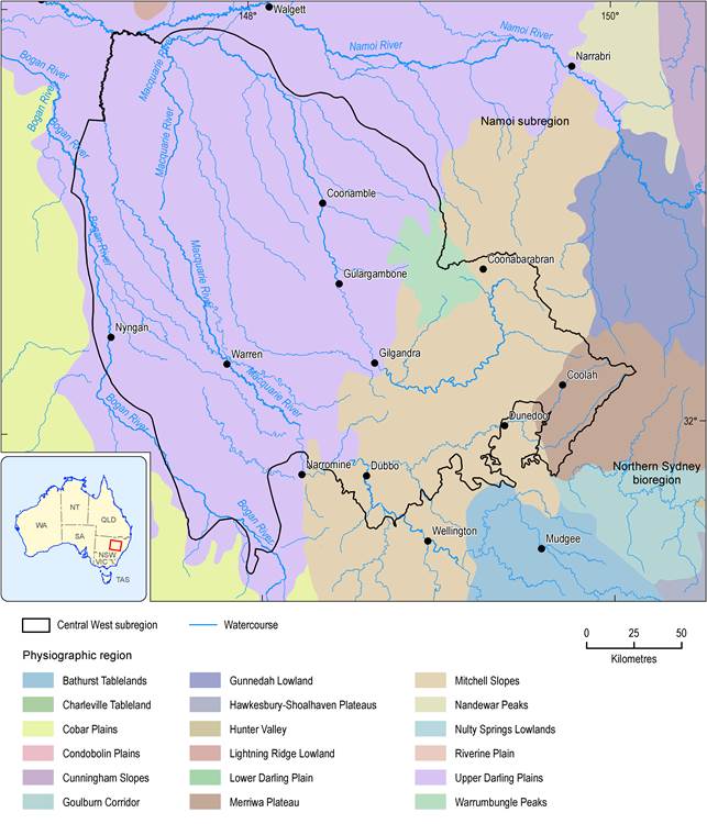
Figure 5 Physiographic regions of the Central West subregion
As defined in Pain et al. (2011)
1.1.2.1.2 Soils and land capability
The subregion comprises a wide range of soil types (Figure 6), but the dominant soils on the Upper Darling Plains and Cobar Plains are grey and brown Vertosols and red Chromosols (Australian Soil Classification system, Isbell, 2002) (Table 2). The Vertosols are clay soils with shrink-swell properties that exhibit strong cracking when dry. From an agricultural perspective, they are well-structured and have a good mix of pores for both transmitting and storing water, so plant growth on these soils is typically very good relative to other soil types. Because Vertosols can be worked under a very narrow range of moisture conditions, they are better suited to irrigated crops such as cotton, wheat, sorghum and rice than rain-fed crops. Chromosols exhibit a strong texture contrast between the upper and lower horizons. They are among the most widespread soils used for agriculture in Australia, particularly those with red subsoils (Isbell, 2002). A narrow belt of Dermosols occur along the Macquarie channel, which have structured horizons at depth, but lack strong texture contrast between upper and lower horizons. They can be hard to differentiate from Vertosols. Other significant soils in the subregion are Sodosols (soils with strong texture contrast between the upper soil horizons and the lower sodic horizons) and Ferrosols (soils having high free iron and generally high clay content), both of which occur extensively in the Castlereagh and Talbragar catchments, and Tenosols (soils with weak pedologic organisation apart from the upper horizon) around Dubbo. Sodic soils have disproportionately high levels of sodium ions, which make them inherently unstable. They disperse readily in water and are, hence, highly erodible. They impede water infiltration, reduce water holding capacity, and ultimately limit plant growth.
Soil condition is the ability of soil to deliver a range of essential services, including habitat for soil biota, nutrient cycling, water retention and primary production. In the most recent systematic state wide assessment of NSW soil health, commenced in 2008 under the NSW Natural Resources Monitoring, Evaluation and Reporting Strategy 2010–2015 (NSW DECCW, 2010d), soil condition on the Lower Darling Plains and Cobar Plains was assessed as generally good (that is, a small loss of condition relative to a reference condition for a range of soil indicators), but on the Sodosols and red Chromosols of the Mitchell Slopes, soil condition was generally assessed as fair (that is, noticeable loss of soil function relative to a reference condition), with some indicators giving a poor rating (NSW DECCW, 2010b). The main land and soil hazards in the subregion are soil salinity and waterlogging, structural decline, carbon decline, acidification and wind erosion. Salinity reflects an accumulation of salt in the soil or on the ground surface, with the potential to cause profound terrestrial and aquatic ecosystem damage, including massive erosion. It is commonly associated with waterlogging and sodic soils, and is a problem in the region around Dubbo and towards Coonabarabran. Structural decline and carbon decline are issues for the Lower Darling Plains soils.
Land capability is the inherent physical capacity of the land to sustain long-term land uses and management practices without degradation to soil, land, air and water resources (Dent and Young, 1981). The land and soil capability classification scheme takes account of limitations for sustainable use arising from water erosion, wind erosion, salinity, topsoil acidification, shallow soils/rockiness, soil structure decline, waterlogging and mass movement (NSW OEH, 2012). Figure 7 shows land and soil capability classifications for the Central West subregion based on the most limiting hazard. Much of the Upper Darling Plains is classed as land and soil capability Classes 2 and 3. Class 2 indicates very good cropping land with fertile soils and short, low slopes. Limitations can be managed with readily available, easy to implement management practices. Class 3 is capable of supporting most land uses, but more intensive management practices are needed to avoid moderate-severity degradation from water erosion, wind erosion, soil acidification, salinisation, structural decline and/or loss of organic carbon. In the Warrumbungle and Liverpool ranges, land and soil capability Classes 5, 6 and 7 are more extensive, reflecting the steeper terrain. These lands can support a variety of low intensity land uses, such as grazing, forestry and nature conservation. On the Vertosols in the west of the region, significant areas of Class 6 and 7 lands reflect vulnerability to wind erosion. Highly specialised management practices can overcome some limitations to cropping on Class 5 land, but Classes 6 and 7 indicate low to very low capability land, best suited to light grazing, forestry and nature conservation (NSW OEH, 2012). In 2009, the former Central West Catchment Management Authority and the former NSW Department of Environment, Climate Change and Water assessed the extent to which land was being used within capability in the former Central West catchment management area. In the subregion, the majority of land is being used ‘at capability’, meaning that the risk of degradation under current land use and management is low (NSW DECCW, 2010a). However, acidification, the trend towards increasingly acid soils, caused by inappropriate management practices (for example from over-intensive use, allowing excessive leaching, overuse of nitrogen fertilisers and insufficient use of lime) is widespread in the Dubbo-Coonabarabran area (DECWW, 2010a).
Table 2 Soils, classified using Australian Soil Classification (Isbell, 2002)
|
ASC soil class |
Percentage of total area of subregion (%) |
|---|---|
|
Vertosols |
41% |
|
Chromosols |
27% |
|
Sodosols |
14% |
|
Ferrosols |
5% |
|
Tenosols |
4% |
|
Kurosols |
3% |
|
Kandosols |
3% |
|
Dermosols |
2% |
|
Rudosols |
1% |
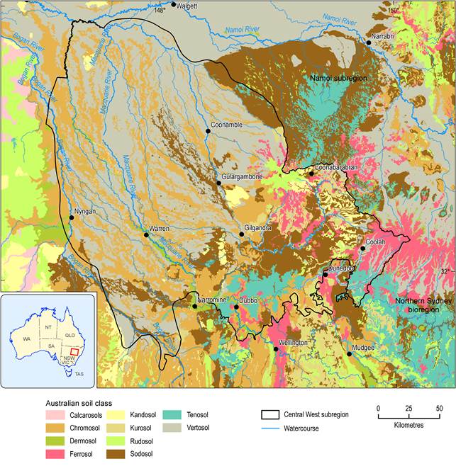
Figure 6 Soils classified using the Australian Soil Classification
Source data: National Soil Grids (ASRIS, 2011)
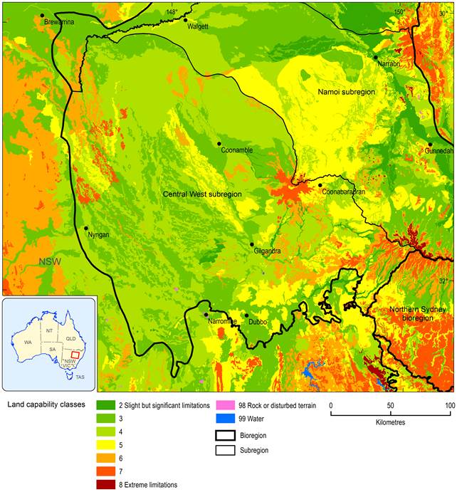
Figure 7 Land and soil capability
Source data: Land and Soil Capability mapping of NSW (NSW OEH, 2013a)
1.1.2.1.3 Land cover
Figure 8 shows the land cover for the subregion in 2008, based on remotely sensed Enhance Vegetation Index (EVI) data from the Moderate Resolution Imaging Spectroradiometer (MODIS) on the Terra and Aqua satellites that are post-processed to convert vegetation greenness to a land cover type (Geoscience Australia, 2011b). In the area up-catchment of Dubbo, Gilgandra and Coonabarabran, there are extensive areas of open woodland and scattered trees among pasture lands. In the north and west, cropping and pasture lands dominate, with areas of scattered to sparse tree cover along distributary channels and in the Macquarie Marshes. Table 3 summarises the extents of different land cover types.
The region has undergone significant modification of its land cover, with an estimated 62% of the land cleared of native vegetation. This has included reducing much of the cover to a large number of small, isolated remnants on the less fertile and productive soils, and a smaller number of scattered larger reserved remnants (CW CMA, 2013). Across the subregion, there is a trend of increasing native vegetation cover from south-east to north-west (Goldney et al., 2007). ‘Non-native’ and ‘native/non-native mosaic’ land covers dominate the north-south swathe of land between Dubbo and Nyngan. ‘Intact native’ vegetation cover peppers this area but becomes more extensive and dominant in the north-west of the subregion (NSW DECCW, 2010c). There are sizable tracts of ‘intact native’ vegetation north-east of Dubbo and on the Warrumbungle Ranges around Coonabarabran, both of which are managed for conservation and not subject to severe pressures.
Table 3 Area and percentage of subregion for each land cover type in Central West subregion
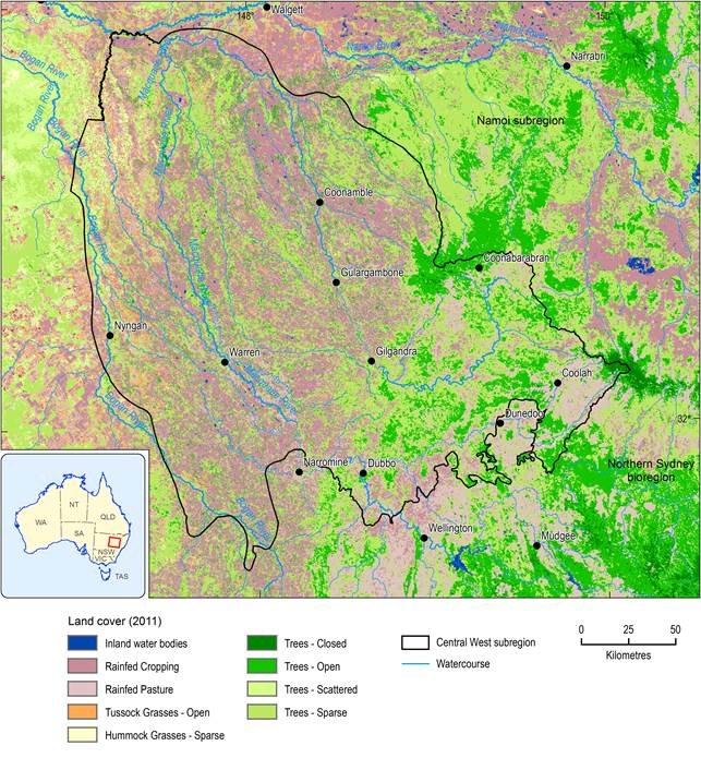
Figure 8 Land cover in the Central West subregion
Source data: The national dynamic land cover dataset (Geoscience Australia, 2011b)
The methods used to produce the land cover map are not very sensitive to use of irrigation water and irrigated land covers are often mapped as rain-fed covers. For irrigated land covers, the land use map (Figure 9) should be consulted.
The 2010 State of the Catchment report for the Macquarie, Castlereagh and Bogan river basins (NSW DECCW, 2010c) rated the vegetation condition as fair and the pressures on land cover as moderate. Across the region, only 2% of land cover is deemed ‘residual’, referring to native vegetation community structure, composition and regenerative capacity that is intact and has not undergone significant perturbation from land use or land management practices. A further 25% of land cover is classified as ‘modified’, meaning native vegetation community structure, composition and regenerative capacity is intact, but the community has been perturbed by land use and management practices. The remaining 73% of the region comprises transformed and replaced land covers, which reflect varying degrees of modification that compromise the ability of the native vegetation cover to recover or re-establish. The main pressures on vegetation extent and condition come from dryland agriculture and plantations (76%). Intensive uses (2%) and irrigated agriculture and plantations (1%) have small, localised impacts around Dubbo and along the Macquarie River between Dubbo and the Macquarie Marshes.
Of the remnant vegetation, there are large areas of dry sclerophyll forest north of Dubbo dominated by box, red gum and ironbark trees with a sub-canopy of cypress pine. These forests are a southern extension of the Pilliga scrub community that have formed on alluvial sediments washed out from the surrounding sandstone ranges. The lower part of the Macquarie river basin is dominated by riverine and floodplain woodlands with river red gum trees along the watercourses and black box trees dominant on the floodplain (Green et al., 2011).
The subregion boasts the Macquarie Marshes, which span an area of 2000 km2 of floodplain between Marebone Weir and Carinda in the north-west of the subregion. Owing to their size, diversity of wetland types, extent of wetland communities and large-scale colonial waterbird breeding events, they are nationally and internationally important. The southern marshes consist of a series of individual wetland systems, including Back, Buckiinguy, Monkey and Monkeygar swamps and Mole Marsh. The northern marshes consist of extensive areas of common reed and river red gum woodlands (CSIRO, 2008). The Ramsar listed part of the Marshes covers 19,850 ha and includes the Macquarie Marshes Nature Reserve plus two additional areas of private property land (NSW OEH, 2013b).
Eight endangered ecological communities, listed under the NSW Threatened Species Conservation Act 1995, occur within this subregion. On 13 August 2013, the wetlands and inner floodplains of the Macquarie Marshes were listed by the Commonwealth under the Environment Protection and Biodiversity Conservation Act 1999 (EPBC Act) as critically endangered. The EPBC Act also protects the critically endangered natural grasslands on basalt and fine-textured alluvial plains of northern NSW and southern Queensland that occur in the subregion. More information on the ecology of the subregion can be found in Section 1.1.7 .
