3.2.2 Causal pathways


The conceptual model of causal pathways describes the logical chain of events ‒ either planned or unplanned ‒ that link coal resource development to potential impacts on water and water-dependent assets. The causal pathways provide the logical and transparent foundation for the impact and risk analysis.

A systematic hazard analysis, using the Impact Modes and Effects Analysis method (described in companion submethodology M11 (as listed in Table 1) for hazard analysis (Ford et al., 2016)), was undertaken for the Gloucester subregion to identify the activities that occur as part of coal resource development that might result in a change in the quality or quantity of surface water or groundwater. Hazards were prioritised according to the likelihood, severity and detectability of potential impacts (Dataset 1). It is important to ensure that all hazards are addressed for the impact and risk analysis to meet the necessary quality criteria. This does not mean that all causal pathways need to be assessed in the same way, only that they are all addressed in some way.

The many individual ‘hazards’ themselves were not represented directly in the hydrological models, but instead they were grouped into four causal pathway groups, which reflect the main hydrological pathways via which the effects of a hazard can propagate from its origin. These simplified pathways were broadly represented in the BA hydrological models. These causal pathway groups are:

  • ‘Subsurface depressurisation and dewatering’
  • ‘Subsurface physical flow paths’
  • ‘Surface water drainage’
  • ‘Operational water management’.

Figure 6 illustrates these causal pathways and Table 3 provides a more detailed list of the potential hazards arising from coal resource development in the Gloucester subregion, grouped into the four causal pathway groups. Further details about hazards, their identified effects and their link to causal pathway groups are in companion product 2.3 for the Gloucester subregion (Dawes et al., 2018).

Figure 6

Figure 6 Conceptual diagram of the causal pathway groups associated with coal seam gas operations and open-cut coal mines for the Avon River basin in the Gloucester subregion

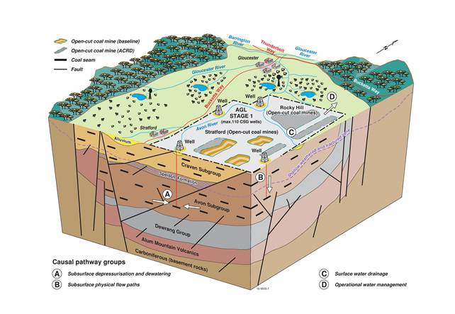
This schematic diagram is not drawn to scale. CSG = coal seam gas

The hydrological models represent causal pathways through their conceptualisations and parameterisations. The outputs from the hydrological models do not identify individual causal pathways but integrate the various possible causal pathways into the predicted hydrological response at particular points in space and time.

The effects of some hazards were not modelled. Some cannot be modelled due to scale or complexity and were addressed qualitatively using the current conceptual understanding and knowledge base. Changes in water quality due to coal resource development activities were considered only through potential effects on stream salinity (Section 3.3.4). Some identified hazards were deemed to be local in scale and addressed by existing site-based management, whereas some were considered knowledge gaps (e.g. because the means of disposal for co-produced water extracted during CSG production is unknown). Others were considered of such low likelihood and/or consequence for broader cumulative impacts at the regional scale that they were not included.

While the causal pathway groups are generic, the physical characteristics of a subregion, such as its geological, geophysical and topographic architecture, and related surface water and groundwater networks, will influence the hydrological connectivity across the subregion. The Assessment team’s conceptual understanding of the dominant geological and topographic influences on surface water and groundwater connectivity in the Gloucester subregion are described in companion product 2.3 (Dawes et al., 2018).

Table 3 Causal pathways in the Gloucester subregion and their associated hazards, hydrological effects, system components and temporal context

Each causal pathway is listed in a chain of logic from the hazard and associated hydrological effects to system components that may contain assets or ecosystems that may be subject to potential hydrological changes.


Causal pathway group –

Causal pathway

Hazards (impact mode)

Hydrological effects

System components

Temporal context

Subsurface depressurisation and dewatering

Groundwater pumping enabling coal seam gas extraction

Groundwater pumping enabling open-cut coal mining

Groundwater pumping of target aquifer

Aquifer depressurisation

Aquifer depressurisation (coal seam)

Groundwater extraction (groundwater supply bore)

Localised watertable reduction

Reduction in pressure head (pump testing)

Very localised watertable reduction

Groundwater flow (reduction)

Groundwater level

Groundwater pressure

Target aquifer

Short term

Long term

Subsurface depressurisation and dewatering

Unplanned groundwater changes in non-target aquifers

Aquifer depressurisation (fault-mediated)

Aquifer depressurisation (non-target, non-reservoir)

Deliberate dewatering (pit wall stabilisation)

Mis-perforation of target aquifer

Surface water flow

Groundwater direction

Groundwater flow (reduction)

Groundwater pressure

Groundwater quality

Groundwater quantity/volume

Non-target aquifer

Alluvium and watercourses within and downstream of coal resource developments

Medium to long term

Long term

Subsurface physical flow paths

Failure of well integrity

Bore leakage between aquifers

Bore leakage to surface

Fluid loss to aquifer

Incomplete seal

Incomplete/compromised cementing/casing (gas leakage)

Incomplete/compromised cementing/casing (linking aquifers)

Intersection of artesian aquifer

Mis-perforation of target aquifer (connecting aquifers)

Mud pressure imbalance

Seal integrity loss

Surface water quality

Groundwater quality

Groundwater composition

Groundwater pressure

Aquifers within coal resource developments

Watercourses within and downstream of coal resource developments

Short term

Long term

Subsurface physical flow paths

Hydraulic fracturing

Accidental intersection of fault

Changing non-target aquifer properties (physical or chemical)

Changing target aquifer properties (physical or chemical)

Connecting aquifers (too much pressure)

Contaminate non-target aquifer (chemical)

Contaminate target aquifer (chemical)

Intersection of aquifer

Aquifer properties

Groundwater composition

Groundwater pressure

Groundwater quality

Target aquifers within coal resource developments

Non-target aquifers within coal resource developments

Long term

Subsurface physical flow paths

Extracting overburden to access coal

Artificial point of recharge

Enhanced aquifer interconnectivity

Groundwater sink

Linking aquifers, preferential drainage

Surface water flow

Change in zero-flow days

Groundwater direction

Groundwater pressure

Groundwater quality

Groundwater quantity/volume

Alluvium and watercourses within and downstream of coal resource developments

Aquifers within coal resource developments

Medium to long term

Long term

Surface water drainage

Altering surface water system

Change to natural surface drainage

Disruption of natural surface drainage

Surface water direction

Surface water quality

Surface water volume

Groundwater quantity/volume

Alluvium and watercourses within and downstream of coal resource developments

Medium to long term

Operational water management

Processing and using extracted water

Increase discharge to rivers following irrigation

Raise watertable following irrigation

Soil salt mobilisation following irrigation

Surface water flow

Surface water quality

Groundwater level

Groundwater quality

Alluvium and watercourses within and downstream of coal resource developments

Short term

Operational water management

Storing extracted water

Change to natural surface drainage

Disruption of natural surface drainage (freshwater storage)

Disruption of natural surface drainage (mine water storage)

Disruption of natural surface drainage (tailings water storage)

Excessive runoff during closure (water management structures)

Surface water direction

Surface water flow

Surface water quality

Surface water volume

Groundwater quality

Groundwater quantity/volume

Alluvium and watercourses within and downstream of coal resource developments

Medium to long term

Full descriptions of the causal pathways and causal pathway groups are available in companion submethodology M05 (as listed in Table 1) for developing a conceptual model of causal pathways (Henderson et al., 2016).

Last updated:
8 November 2018
Thumbnail of the Gloucester subregion

Product Finalisation date

2018