Three CSG projects are included in the CRDP for the Galilee subregion (Figure 86), namely the:
- Glenaras Gas Project, owned and operated by Galilee Energy Limited in the south of petroleum exploration tenement, Authority to Prospect (ATP) 2019
- Gunn Project, owned and operated by Comet Ridge in ATP 744, and mainly focused in an area just to the east of Lake Galilee
- Blue Energy exploration project in ATP 813, which occurs in the central Galilee Basin, flanked by Glenaras to the west and Gunn to the east.
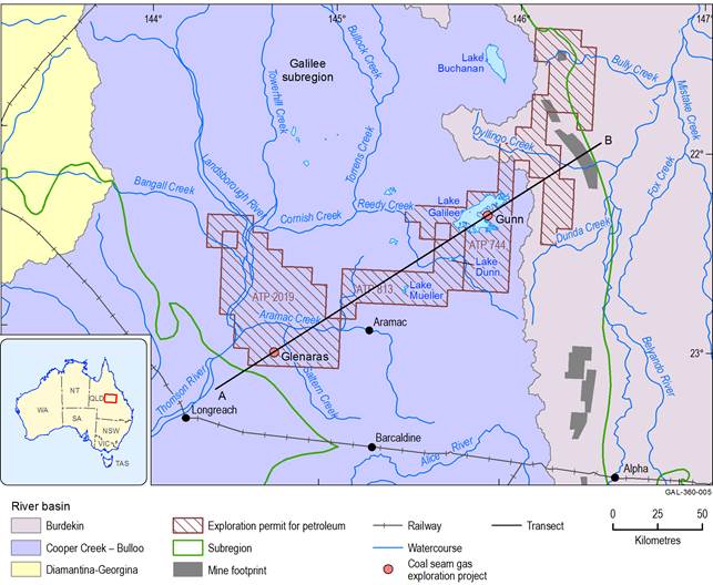
Figure 86 Map of main coal seam gas projects in the Galilee Basin
The transect line A–B depicted on this map is the approximate location of the geological cross-section shown in Figure 87, which extends from the south-west (A) to the north-east (B). Unlike Glenaras and Gunn, the Blue Energy CSG project is not yet focused on a specific location, although several CSG exploration wells have been drilled in ATP 813.
Data: Bureau of Meteorology (Dataset 1); Geological Survey of Queensland (Dataset 5); Bioregional Assessment Programme (Dataset 6)
As discussed in companion product 2.3 for the Galilee subregion (Evans et al., 2018b), it was not possible to quantitatively evaluate the potential hydrological impacts of any CSG project as part of this BA. Consequently, this section presents a qualitative discussion and analysis of the potential causal pathways that may result from future CSG development in the Galilee subregion, as well as the main water-dependent ecosystems and assets potentially affected within existing CSG exploration tenements.
The CSG projects in the Galilee subregion CRDP occur west of the Great Dividing Range in the Cooper Creek – Bulloo river basin (Figure 6). This means that the surface water and shallow groundwater systems are largely hydrologically disconnected from the coal mining projects in the central-eastern Galilee Basin. These projects target CSG resources in the Permian coal measures, predominantly under a thick cover of sedimentary rocks that are either part of the upper Galilee Basin sequence, or the overlying Eromanga Basin. In the vicinity of the three CSG projects, the depth to the upper Permian coal measures varies from about 800 to 1050 m below surface (Figure 87). Figure 10 in companion product 2.3 for the Galilee subregion (Evans et al., 2018b) provides further detail on variation in overburden thickness for the upper Permian coal measures across the entire Galilee subregion.
One of the many factors that influence the commercial viability of CSG development and production is the in situ gas content of the coal. Previous exploration and appraisal studies have shown that the gas content of coals in the upper Permian coal measures varies considerably across the areal extent of the Galilee subregion and also with depth below surface. As outlined in Figure 24 of companion product 2.1-2.2 for the Galilee subregion (Evans et al., 2018a), coals with higher gas content mainly occur at depths of 900 to 1200 m. The gas contents of coal seams rapidly decrease to relatively low levels at depths of less than 700 m (commonly less than 1 m3/tonne (dry ash free)). Figure 25 and Figure 26 of companion product 2.1-2.2 for the Galilee subregion (Evans et al., 2018a) illustrates the understanding (as of April 2016) of the variability of gas contents across the upper Permian coal measures, and with depth. The most elevated gas contents are clustered in the central part of the Galilee subregion (i.e. north of Barcaldine), in the vicinity of the three CSG projects in the CRDP.
The timing and extent of future CSG development (and eventual commercial-scale production) in the Galilee Basin are currently uncertain. However, based on the known distribution of gas contents within the basin’s main coal-bearing strata, future CSG development is considered unlikely to occur at the scale of the entire basin, or at depths of less than 700 m below surface. Based on the current understanding of prospective CSG host rocks, the most likely CSG development fairway extends from the area around the Glenaras Gas Project in the central-western part of the basin (i.e. east of Longreach) towards the north-east, past the town of Aramac and across to the Comet Ridge tenements near Lake Galilee (Gunn Project area). The most likely production will occur within the depth zone where elevated gas contents exist, typically at depths of 900 to 1200 m below surface (Figure 87).
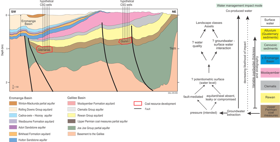
The potential hydrological links that may develop due to subsurface depressurisation of coal seams is schematically depicted on the right. The stratigraphic units shown in the legend are classified according to their dominant hydrogeological characteristics (i.e. either as aquifers or aquitards).
3.6.2.1.1 Potential causal pathways
Causal pathways through which CSG activities may result in hydrological impacts are detailed in Section 2.3.5.3.1 of companion product 2.3 for the Galilee subregion (Evans et al., 2018b). The main causal pathways identified include:
- ‘groundwater pumping enabling coal seam gas extraction’
- ‘unplanned groundwater changes in non-target aquifers’
- ‘failure of well integrity’
- ‘hydraulic fracturing’.
The extent and magnitude of subsurface hydrostatic depressurisation required for CSG production, and how depressurisation may propagate laterally and vertically through a series of aquifers and aquitards, depends on a variety of geological, hydrological and operational factors (Figure 87). A detailed discussion of how these factors may influence causal pathways associated with future CSG production in the Galilee subregion is in Section 2.3.5.3.1.1 of companion product 2.3 (Evans et al., 2018b). Depressurisation effects within the coal seams will propagate laterally through the coal measures at a certain rate and (usually to a much lesser extent) vertically through the adjacent geological units. The extent and magnitude of depressurisation will also depend on the overall size (footprint), spacing and layout of production wells at each future CSG field. These types of important design details are currently unknown for the most advanced CSG exploration and appraisal projects in the Galilee subregion.
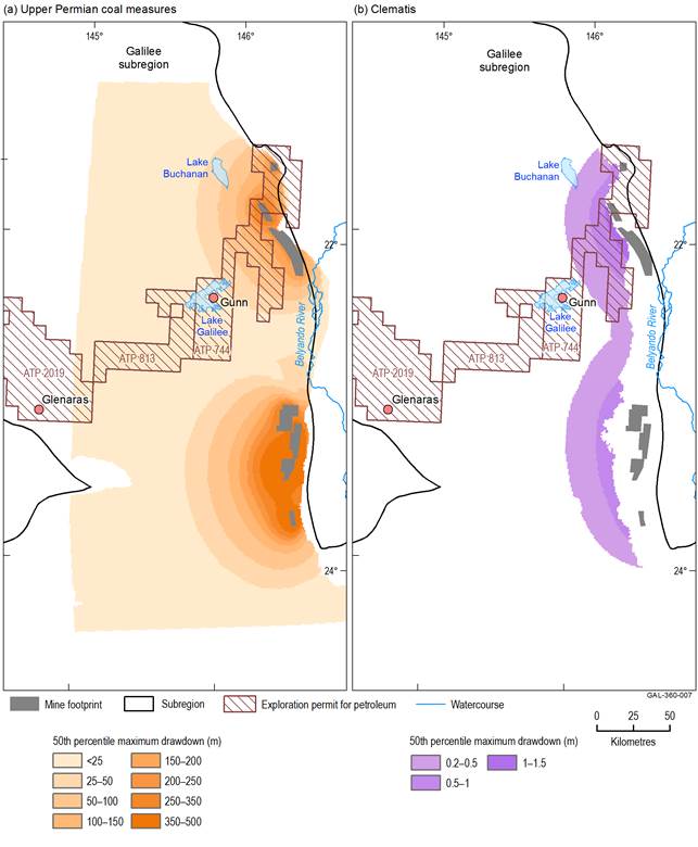
Any future groundwater drawdown in the upper Permian coal measures due to CSG production has the potential to be additional (cumulative) to drawdown attributed to the coal mine projects in the modelled CRDP (see Section 3.3 for detail). The groundwater modelling results outlined in companion product 2.6.2 for the Galilee subregion (Peeters et al., 2018) for the modelled CRDP suggest that in the vicinity of the Gunn CSG project area, the median percentile of maximum drawdown (due to the seven coal mines modelled in this BA) is slightly less than 25 m in the upper Permian coal measures (Figure 88). Further westwards, the median of maximum drawdown across the Blue Energy tenement is less than 20 m, with the boundary of the groundwater modelling domain (for this BA) occurring between the Blue Energy tenement and the Glenaras Gas Project. At Glenaras, the depth to the coal measures is commonly around 1000 m below surface, and there are no water-dependent assets (at the surface) in the vicinity of Glenaras that are likely to be directly affected by groundwater depressurisation (due to CSG extraction) in the deep coal-bearing units. However, when this water is pumped to surface it will require a long-term, sustainable water management plan to handle what are potentially very large volumes of water in a surface environment where ecosystems are generally not adapted to coping with such large and sustained quantities. The quality of the water released from the deep coal seams may also be such that it will require further treatment at the surface (e.g. reverse osmosis to decrease salinity), prior to any release off site or for other uses, such as irrigation water. There may also be large volumes of brine and/or salt (a by-product of the extraction and treatment of co-produced water) that will need to be effectively managed on site, or removed for disposal at an approved waste management facility. A potential positive impact could be that CSG fields within the cumulative drawdown cone for the coal mine projects may have to pump less water in order to achieve sufficient gas flows.
Data: Geological Survey of Queensland (Dataset 5); Bioregional Assessment Programme (Dataset 6, Dataset 7)
The Clematis Group aquifer is the main water supply for many pastoral bores in the Galilee subregion, and is a key aquifer for several groundwater management units (e.g. the Barcaldine North 3 and Barcaldine East 4 groundwater management units). It is also likely to be a contributing source aquifer for some springs within the central-eastern Galilee Basin, including the Doongmabulla Springs complex near the Carmichael Coal Mine (companion product 2.3 for the Galilee subregion (Evans et al., 2018b)). The results outlined in companion product 2.6.2 (Peeters et al., 2018) suggest that where present, the Rewan Group aquitard (Figure 87) effectively impedes vertical propagation of depressurisation from the upper Permian coal measures into overlying hydrostratigraphic units such as the Clematis Group. This is clearly seen in comparative drawdown maps in Figure 88, where the magnitude and extent of drawdown in the Clematis Group aquifer due to coal mine dewatering (in the modelled CRDP) is substantially less than the modelled drawdown in the upper Permian coal measures.
In the vicinity of the Gunn Project the Rewan Group aquitard is greater than 300 m thick (companion product 2.1-2.2 for the Galilee subregion (Evans et al. 2018a)). Here, the probability of cumulative drawdown from coal mines in the modelled CRDP (at the 50th percentile) is less than 0.2 m in the Clematis Group aquifer (Figure 88). However, any potential drawdown in the Clematis Group aquifer due to pumping at the Gunn CSG Project (which has not been modelled for this BA) would be in addition to drawdown from the coal mine projects.
The Glenaras Gas Project is situated near the western margin of the Galilee Basin (Figure 86). In this area, the Rewan Group aquitard is much thinner than in the central and eastern parts of the basin (Figure 87). Near Glenaras, the Rewan Group is only about 20 m thick, and progressively pinches out further westwards towards the margin of the Galilee Basin (companion product 2.3 for the Galilee subregion (Evans et al., 2018b)). The thin to absent nature of the Rewan Group in the western part of the basin means that the upper Permian coal measures may be (at least partly) in direct contact with overlying aquifers of the GAB, such as the Hutton Sandstone. Groundwater modelling results from companion product 2.6.2 (Peeters et al., 2018) did not extend as far west as the Glenaras Gas Project, as it occurs beyond the edge of the modelling domain (at the western-most edge of the groundwater modelling domain, the 50th percentile of drawdown in the upper Permian coal measures was much less than 25 m). However, if depressurisation due to production from Glenaras were to extend westward to areas where the Rewan Group aquitard was missing, then there may be some potential for drawdown in the coal-bearing units to propagate upwards and impact on groundwater systems in overlying aquifers such as the Hutton Sandstone. Figure 7 in companion product 1.5 for the Galilee subregion (Evans et al., 2015) indicates that some pastoral bores near the Glenaras Gas Project draw groundwater from the Hutton Sandstone aquifer. Consequently, further evaluation and modelling of depressurisation effects would be required to better understand the extent of both lateral and vertical propagation, once the CSG development plans at Glenaras are more advanced.
3.6.2.1.2 Landscape classes and assets near coal seam gas projects
The Glenaras Gas Project is near the far western margin of the Galilee subregion, and most of the surrounding area is dominated by the ‘Dryland’ landscape group (Figure 89). However, some areas of the ‘Floodplain, terrestrial GDE’ landscape group are associated with surface water systems near Glenaras, such as Rodney Creek, several kilometres to the east, and Aramac Creek further north. These are mostly classed as temporary non-GDE streams, and both are tributaries of the larger Thomson River, which is the main surface water feature within this part of the subregion. There are no known GAB springs in the vicinity of the Glenaras Gas Project.
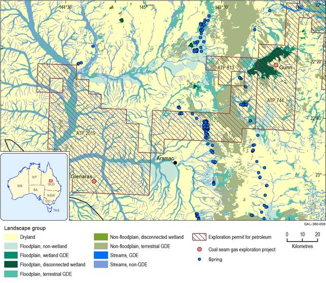
Figure 89 Landscape groups near coal seam gas exploration tenements in the central Galilee Basin
This map only shows the petroleum exploration tenements (known as Authority to Prospect, ATP) that relate to the Glenaras, Blue Energy and Gunn coal seam gas projects. To improve display, some other coal seam gas and coal exploration tenements are not depicted.
GDE = groundwater-dependent ecosystem
Data: Bioregional Assessment Programme (Dataset 4); Geological Survey of Queensland (Dataset 5, Dataset 8); Bureau of Meteorology (Dataset 9); Queensland Herbarium, Department of Science, Information Technology, Innovation and the Arts (Dataset 10)
One of the main landscape classes near the Gunn CSG Project is ‘Floodplain, disconnected wetland’, which coincides with much of the mapped extent of nearby Lake Galilee. This is a large ephemeral salt lake within a hydrologically enclosed catchment in the headwaters of the Cooper Creek – Bulloo river basin (Figure 89). Other water-dependent ecosystems that occur within the vicinity of Lake Galilee and the Gunn CSG Project include ‘Floodplain, non-wetland’, ‘Floodplain terrestrial GDE’, and ‘Non-floodplain, terrestrial GDE’ landscape groups. Lake Galilee is included in A directory of important wetlands and the Register of the National Estate and is widely recognised as an Important Bird Area (Sparrow et al., 2015). Any changes to the surface water regime due to CSG production in this area (i.e. changes to water flow volumes or timing, or water quality) may potentially be cumulative as the lake occurs within a hydrologically closed surface water basin (i.e. the local surface water system cannot be flushed clean, even following heavy rainfall events). Potential hydrological impacts of any future CSG development at Gunn would need to be considered in the context of Lake Galilee’s many ecological, sociocultural and Indigenous values.
A variety of landscape classes occurs across ATP 813, Blue Energy’s CSG exploration tenement in the central Galilee Basin. These include extensive areas of dryland landscapes, as well as non-floodplain, terrestrial GDEs. Many different floodplain ecosystems, including those associated with the ‘Floodplain, disconnected wetland’ and ‘Floodplain, terrestrial GDE’ landscape groups also occur in the vicinity of Lake Dunn (Figure 90). Temporary west- and south-flowing streams in the upper catchment of Aramac Creek, including some potential areas of GDE streams, also occur in the central and western parts of ATP 813.
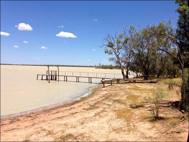
Figure 90 Lake Dunn in the central Galilee subregion
Source: Constable J and Love K (2014)
Importantly, there are many springs within ATP 813, most of which belong to the larger Barcaldine supergroup (Figure 89). Of particular note are Edgbaston springs (part of the Pelican Creek Springs Complex) which are a recognised centre of endemism within the broader system of GAB springs across the Galilee subregion. There are multiple threatened endemic flora and fauna species known only from this spring system (Fensham et al., 2016). Due to the important ecological values of Edgbaston springs, they are listed on the Register of the National Estate, in A directory of important wetlands and in the Collaborative Australian Protected Area Database (companion product 1.3 for the Galilee subregion (Sparrow et al., 2015)). The springs are also part of a nationally threatened ecological community that is listed under the Commonwealth’s Environment Protection and Biodiversity Conservation Act 1999, ‘The community of native species dependent on natural discharge of groundwater from the Great Artesian Basin’ (Fensham et al., 2010).
