The zone of potential hydrological change is the area within the assessment extent where changes in hydrology due to additional coal resource development exceed defined thresholds for both groundwater and surface water. The impact and risk analysis presented in Section 3.4 and Section 3.5 focuses mainly on landscape classes and ecological assets that intersect with this zone. Any landscape class or asset wholly outside of the zone of potential hydrological change is generally considered very unlikely (less than 5% chance) to be impacted due to additional coal resource development. However, an important exception to this rule is for cases where impact and risk analysis is undertaken for assets that are interpreted to source groundwater from deeper confined aquifer systems (i.e. deeper aquifers below the level of the upper Quaternary alluvium and Cenozoic sediment aquifer in the Galilee subregion, such as the Clematis Group aquifer). Examples of such assets include discharge springs and their local ecosystems, and groundwater bores that tap deeper groundwater sources (as further discussed in Section 3.4.3 and in the economic assets analysis in Section 3.5.3). In these cases, a similar type of analysis is done as for the zone of potential hydrological change, with the focus being on the probabilistic groundwater drawdown results obtained for the deeper source aquifers instead of the upper Quaternary alluvium and Cenozoic sediment aquifer (companion product 2.6.2 for the Galilee subregion (Peeters et al., 2018)). Of course, such analysis is predicated on the source aquifer for the relevant springs or bores being accurately known and, in cases where ambiguity may exist as to the source, the analysis presented here has relied on the best available data and information available. This has been supplemented in some cases by additional review and analysis to guide the Assessment team’s conceptual understanding.
The zone of potential hydrological change for the BA of the Galilee subregion is defined as the union of the groundwater zone of potential hydrological change (Section 3.3.1.1) and the surface water zone of potential hydrological change (Section 3.3.1.2). It is presented in Section 3.3.1.3.
3.3.1.1 Groundwater
The groundwater zone of potential hydrological change is defined as the area with a greater than 5% chance of exceeding 0.2 m drawdown in the uppermost aquifer, due to additional coal resource development (Figure 20). As previously discussed, the relevant aquifer in the Galilee subregion used to define the zone is the near-surface (unconfined) Quaternary alluvium and Cenozoic sediment layer (Section 3.2.3). The 5% chance is determined based on the uncertainty analysis described in Section 2.6.2.8 of companion product 2.6.2 for the Galilee subregion (Peeters et al., 2018). It means that, for each assessment unit in the groundwater zone, at least 5% of groundwater model runs exceeded this specified level of drawdown. Groundwater impacts of coal mines and CSG projects are regulated under Queensland and Australian Government legislation, and various state regulatory and management frameworks also apply. The 0.2 m drawdown threshold adopted in BAs is consistent with the most precautionary minimal impact threshold under Queensland’s Water Act 2000.
The groundwater component of the zone of potential hydrological change consists of two separate areas near the central-eastern margin of the Galilee subregion (Figure 20). The two drawdown zones extend to the east beyond the boundary of the Galilee Basin, as the upper alluvial/sediment aquifer is geologically younger than the rocks of the Galilee Basin and is not constrained (conceptually) to only occur within the basin extents. To the west, the area of each drawdown zone does not overlap with the eastern boundary of the geologically younger Eromanga Basin sequence that overlies much of the Galilee Basin beyond this line. The Eromanga Basin contains most of the main productive aquifers of the Great Artesian Basin (GAB) (Ransley et al., 2015).
An important point to note here is that some eastern parts of the zone of potential hydrological change extend beyond the boundary of the Galilee assessment extent (Figure 20). This boundary was used to define the area in which landscape classes were developed for this BA, as well as defining the area in which the water-dependent assets were identified for the BA asset register. Consequently, this means that it is not possible to assess impacts and risks to both landscape classes and water-dependent assets in the part of the zone that occurs beyond the boundary of the assessment extent. Although this is a recognised limitation of the current BA, the area of the zone beyond the assessment extent equates to only about 6% of the total area of the zone of potential hydrological change. Additionally, most of this area is predicted to have a relatively low chance of a small level of drawdown, ranging from a 5% to 10 % chance of 0.2 m of drawdown in the upper Quaternary alluvium and Cenozoic sediment aquifer. Within this area there is no drawdown impact predicted to affect the aquifers of either the Clematis Group or upper Permian Coal Measures, as both of these geological units do not exist in the eastern part of the zone.
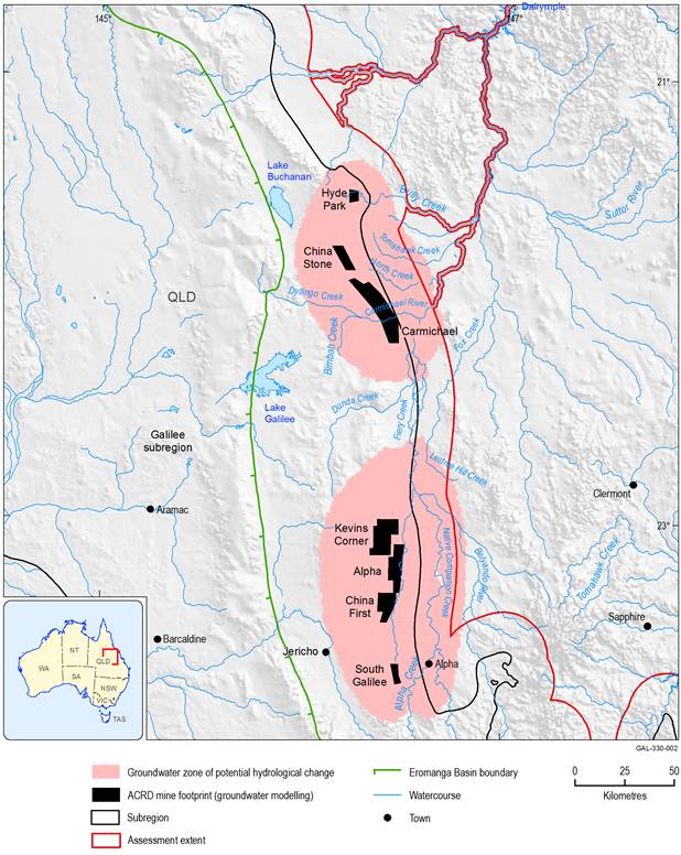
The two areas depicted here are defined based on at least a 5% chance of groundwater drawdown exceeding 0.2 m in the Quaternary alluvium and Cenozoic sediment aquifer due to additional coal resource development. Coal mine development footprints as used in the groundwater modelling for the Galilee subregion are shown.
ACRD = additional coal resource development
Data: Bioregional Assessment Programme (Dataset 1, Dataset 2), Geoscience Australia (Dataset 3)
The separate groundwater drawdown zones defined here for the BA of the Galilee subregion cover an area in which cumulative groundwater impacts in the upper aquifer may occur due to multiple coal mining operations. These zones clearly indicate that, at the 95th percentile of groundwater model results, drawdown from individual mines may overlap spatially and temporally, thereby potentially leading to cumulative hydrological impacts. Such impacts as modelled at the upper probabilistic range for this BA exceed the extent of drawdown in aquifers previously reported for the individual mine developments (e.g. in the environmental impact statements (EIS) for each proposed mine – see Section 2.6.2.2 in companion product 2.6.2 for further information about the groundwater models previously developed for each proposed mine). However, when the BA modelling is considered across the entire range of results (i.e. from the 5th to the 95th percentile), the predicted groundwater impacts of individual mines all fall within this probabilistic range.
The southern cumulative drawdown zone is the larger of the two polygons that comprise the groundwater zone and covers approximately 7898 km2, including the proposed coal mining operations at South Galilee, China First, Alpha and Kevin’s Corner. The northern part of the zone encompasses about 5466 km2 and includes the Carmichael, China Stone and Hyde Park coal mines. Overall, the combined area of the groundwater zone of potential hydrological change is 13,364 km2, which includes the 986 km2 area covered by the mine exclusion zone (Section 3.3.1.3).
Many ecosystems and ecological assets, as well as some economic assets, are interpreted to source their water requirements from the shallow (near-surface) groundwater system. Hence, the zone of potential hydrological change provides an entirely appropriate construct in the BA for ruling out impacts to such ecosystems and assets (i.e. if they occur beyond the extent of the zone then they are considered very unlikely to be impacted due to additional coal resource development). In the Galilee subregion, the near-surface aquifer is represented by the Quaternary alluvium and Cenozoic sediment layer, which is one of three layers modelled in the analytic element model (AEM) for the Galilee subregion where drawdown predictions are made.
However, the zone of potential hydrological change is not suitable for assessing impacts to ecological or economic assets that may rely on access to deeper water sources. In the Galilee AEM, there are two deeper groundwater systems modelled –1) the aquifers of the Clematis Group and 2) the upper Permian coal measures (companion product 2.6.2 (Peeters et al., 2018)). For any assets that are interpreted to source their water requirements from these two deeper aquifers, a similar 0.2 m threshold of drawdown at the 95th percentile is applied to identify assets that can be ruled out from potential impact, or if there may be potential for groundwater changes to cause adverse impacts. This process of defining a deeper analysis zone to assess potential impacts to some water-dependent assets is further discussed in Section 3.4.3 (for springs) and Section 3.5.3 (for economic assets).
3.3.1.2 Surface water
The thresholds to define surface water changes for the impact and risk analysis for the BA of the Galilee subregion are presented in Table 9. These thresholds apply to the suite of hydrological response variables reported in companion product 2.6.1 for the Galilee subregion (Karim et al., 2018b), and were used to define the surface water component of the zone of potential hydrological change. Together, the hydrological response variables (see Table 9) represent potential changes across the surface water flow regime, ranging from low flows (i.e. zero-flow days (ZFD), low-flow days (LFD), low-flow spells (LFS) and length of the longest low-flow spell (LLFS)) to high flows (daily flow at the 99th percentile (P99) and high-flow days (FD)), and include two other variables to represent changes in annual flow volume (AF) and interquartile range (IQR) (see companion submethodology M06 (as listed in Table 1) for surface water modelling (Viney, 2016) for further details). As previously explained, none of the streams experience any baseline hydrological changes due to coal resource development in the Galilee subregion.
Table 9 Surface water hydrological response variables and the thresholds used in defining the surface water component of the zone of potential hydrological change
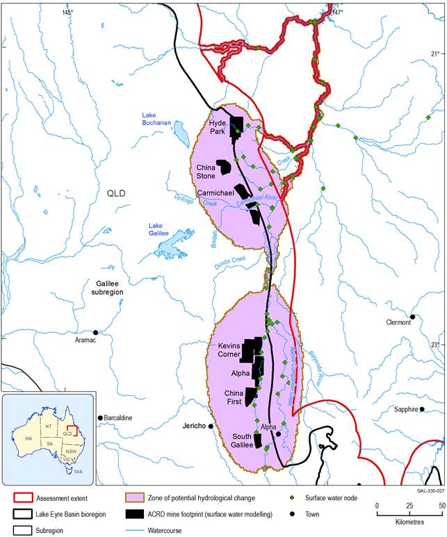
A location on the modelled stream network is deemed to be in the zone of potential hydrological change if the change in at least one of the eight hydrological response variables in Table 9 exceeds its specified threshold. Probability estimates are derived from the predictions of 347 modelling replicates (companion product 2.6.1 for the Galilee subregion (Karim et al., 2018b)), each of which uses a unique set of model parameter values. A 5% threshold implies that at least 17 of the 347 replicates have modelled changes that exceed the relevant change threshold. If fewer than 17 replicates have modelled changes that exceed the threshold at a particular location, then the change in that hydrological response variable (at that location) is considered very unlikely to impact water-dependent landscape classes and assets. The results of surface water modelling are presented in Section 2.6.1.6 of companion product 2.6.1 for the Galilee subregion (Karim et al., 2018b). Within companion product 2.6.1 (Karim et al., 2018b) Figure 12 to Figure 19 (inclusive) identify the 16 model nodes in the surface water network (out of the 61 nodes in total) where hydrological changes do not exceed the specified threshold values for each variable listed in Table 9. The location of these 16 surface water nodes with hydrological response variable changes below threshold values is shown in Figure 12 (Section 3.2.3.2), and include nodes 12, 17, 21, 23, 26, 28, 31, 46 to 50, 52, 54, 57 and 59.
The surface water zone of potential hydrological change includes all stream reaches that represent the links between model nodes (Figure 12) where the surface water modelling has predicted hydrological changes due to additional coal resource development. The rule set used to interpolate results from surface water model nodes to adjacent stream reaches is shown schematically in Figure 13 and Figure 14 in Section 3.2.3.2 . However, there are also stream reaches included in the surface water zone that were not explicitly modelled, but which may potentially be impacted due to additional coal resource development (e.g. non-modelled streams that occur near to mines). Consequently, these stream reaches could not be ruled out from potential impact and, consistent with the precautionary principle adopted for this BA, they have been included in the definition of the zone. The non-modelled stream reaches included in the surface water zone of potential hydrological change include:
- streams that intersect with areas of proposed coal mining
- some temporary streams within the groundwater zone of potential hydrological change that are considered (e.g. on the basis of independent lines of evidence such as remotely sensed data) to receive some level of baseflow contribution
- temporary streams with assumed hydrological change that could not be quantified.
3.3.1.2.1 Streams intersecting proposed coal mines
On the basis that all of the proposed coal mining operations will substantially alter the pre-development state of any watercourses on the mining lease, any part of the non-modelled stream network that intersects an area of open-cut mining, the surface area above underground longwall panels or a mine-site infrastructure area (including proposed dams) at one of the seven additional coal resource developments is flagged as being potentially impacted. During mine development, each operation will implement various management strategies to address surface water flows along such watercourses, including potential stream diversions around the mine. Consequently, these site-specific operational plans are better able to incorporate and model any local-scale impacts to watercourses or drainage lines that may arise during initial development, and as mining progresses over the course of the entire mine life. The inclusion of streams in the zone above areas of proposed longwall mining is based on the potential for land surface subsidence and/or enhanced surface fracturing to potentially affect various aspects of these watercourses, such as the timing and magnitude of flow, as well as possibly enhancing local recharge to groundwater systems. Any stream segments that partially intersect such mining areas have also been flagged as potentially impacted along any upstream and/or downstream parts of the same reach.
3.3.1.2.2 Temporary streams within the groundwater zone of potential hydrological change
The groundwater component of the zone of potential hydrological change (Figure 20) encompasses many minor, temporary streams that were not specifically included in the surface water modelling network. Some of these stream segments were classed as groundwater-dependent ecosystem (GDE) streams using the general approach taken to develop the landscape classification for the Galilee subregion (refer to Section 2.3.3 in companion product 2.3 for the Galilee subregion (Evans et al., 2018b) for further details about the landscape classification approach). This suggests that some of these streams could potentially be affected by drawdown in the near-surface aquifer (e.g. reducing the magnitude and timing of any baseflow contribution to streams). However, as the landscape classification was done using a standardised regional mapping approach at the scale of the entire assessment extent (which meant that once the various input datasets had been assessed as suitable and fit for purpose for defining the landscape classes, they were not subjected to further desktop or field-based verification), some further independent validation of potential surface water – groundwater interaction within the zone was undertaken to improve upon these initial interpretations at the smaller scale of the zone of potential hydrological change.
Several lines of evidence were used to improve the understanding of potential surface water – groundwater interaction for the minor non-modelled streams in the zone of potential hydrological change. This included analysis of the available groundwater bore records of standing water levels in the zone, which were sourced primarily from information in the Queensland groundwater bore database, and supplemented by data available from some coal mine environmental impact statement (EIS) documentation. This information is presented in Figure 39 in Section 3.4, and clearly shows that the depth to the watertable in much of the zone is greater than 20 m, implying that surface water – groundwater interaction along watercourses in these areas is very unlikely to occur.
Further verification was undertaken using a suite of remote sensing techniques that are currently in development as part of work being undertaken by Digital Earth Australia (Geoscience Australia, 2017). A summary of the methods applied using these remote sensing applications is provided in Section 3.2, focused mainly on evaluating temporal trends in vegetation greenness and detectable surface water using the archive of Landsat imagery. Using Digital Earth Australia outputs (Geoscience Australia, 2017), the Assessment team visually inspected a variety of derived datasets that covered the zone of potential hydrological change. Focusing on the data from several drought periods over the past 30 years allowed watercourses to be evaluated for the likelihood that groundwater contribution played an important role in maintaining vegetation health and/or available surface water during such times. Streams that maintained vegetation cover even during long periods of drought were flagged as being more likely to receive some groundwater contribution than streams that mostly lacked consistently green vegetation during these drier times.
Applying this remote sensing method helped to determine that the main non-modelled stream network in the zone that potentially receives some baseflow contribution occurs along the upper tributaries that feed the Carmichael River. In particular, Dyllingo Creek, Cattle Creek, and lower parts of Surprise Creek may all receive some (at present unquantified) volume of groundwater contribution. Springs belonging to the Doongmabulla Springs complex also occur in the vicinity of reaches of these streams. Sparse groundwater level data suggest that the watertable is relatively shallow (within a few metres of the surface) within these areas (Figure 39 in Section 3.4).
From the analysis of these independent datasets, the Assessment team interpreted that the upper parts of Carmichael River and its tributary network are likely to be the only non-modelled streams in the zone of potential hydrological change that are (at least partially) connected to shallow groundwater flow systems. Consequently, these streams were included in the surface water zone of potential hydrological change, and identified as being potentially impacted (but not quantified) due to groundwater drawdown, which could affect any baseflow contribution that supports these streams. The reaches upstream of the boundary of the groundwater zone of potential hydrological change were not included in this surface water zone.
3.3.1.2.3 Temporary streams with assumed hydrological change
Some reaches of the modelled stream network consist of multiple anabranches (commonly anastomosing reaches) between surface water model nodes. This makes it especially difficult to reliably interpolate the surface water changes from model nodes to any particular anabranch segment. However, if hydrological changes occur at the model nodes upstream and downstream of an anabranch reach it is assumed that a hydrological change will also occur between the two modelled nodes. An example from the zone of potential hydrological change is for the stream reach that occurs between model nodes 44 and 34 (Figure 12), which joins the southern and northern groundwater zones. This stretch of the Belyando River consists of multiple anastomosing channels, all of which are likely to receive surface water flows of variable magnitude, timing and duration. This makes it challenging to reliably assign modelled changes in the hydrological response variables from the adjacent nodes.
In reporting the total length of streams identified as being ‘potentially impacted but not quantified’, there is no distinction made between the three different categories as explained above. Thus, all of the surface water maps shown later in this section simply describe such streams as having ‘unquantified potential hydrological change’. Streams for which the surface water modelling identified that there was no change are not included in the surface water zone of potential hydrological change (e.g. the modelled parts of the Cape River and the Suttor River above their respective junctions with the Belyando River, where all surface water model results were below threshold values (Figure 12)).
3.3.1.2.4 Characteristics of the surface water zone of potential hydrological change
In all, about 3012 km of the total 6285 km (Bioregional Assessment Programme, Dataset 1) of streams in the zone of potential hydrological change were identified as potentially impacted. These streams were used to select the 1 km x 1 km assessment units (Bioregional Assessment Programme, Dataset 1) that intersect the stream network (Bureau of Meteorology, Dataset 4), to define the surface water zone of potential hydrological change. The surface water zone of potential hydrological change is shown in Figure 21, including the footprints of the seven proposed coal mines that were included in the BA surface water modelling.
For the purpose of producing some of the analysis results, it is necessary to prioritise a single stream segment in assessment units containing multiple stream segments. The prioritisation takes into account the stream order of each segment, stream segment lengths and the landscape classes and assets relevant to each particular hydrological response variable. Rules are applied according to the specific circumstances at each assessment unit. A summary of the various rules used in this prioritisation approach is provided in Section 3.2.4.1.2.
The surface water zone of potential hydrological change covers an area of 4115 km2 and encompasses much of the Belyando river basin upstream of Lake Dalrymple (the Burdekin Falls Dam). There is some variability in the application of the rules used to interpolate the node data to the adjacent reaches, and this depends on the hydrological response variables (as node data for some variables allowed for more extensive interpolation from nodes to reaches). This means that the total stream lengths that cannot be quantified can vary depending on the chosen hydrological response variables, ranging from 54% for high-flow days and annual flow, and up to 65% for zero-flow days. Surface water modelling suggests that the catchments of the Cape River, and the Suttor River upstream of its junction with the Belyando River, are very unlikely to be impacted by the seven coal mines that comprise the modelled component of the additional coal resource development.
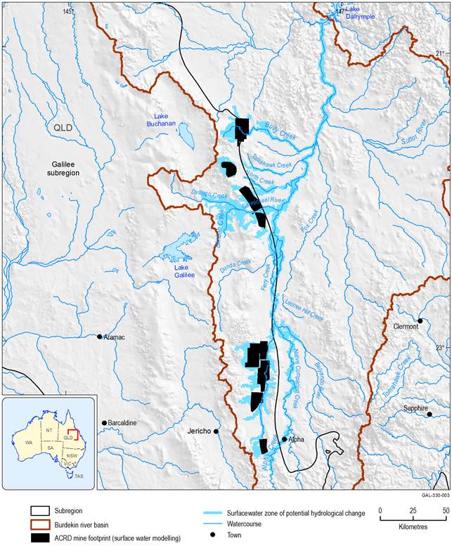
Figure 21 Surface water zone of potential hydrological change for the Galilee subregion
Mine names are shown on Figure 20. Due to variations in the timing of the respective surface water and groundwater modelling workflows undertaken for this bioregional assessment, and the different emphasis placed on defining the extent of mining operations, there may be minor differences in the size and shape of some mine footprints used, respectively, for the surface water and groundwater modelling.
ACRD = additional coal resource development
Data: Bioregional Assessment Programme (Dataset 1, Dataset 5, Dataset 6)
3.3.1.3 Zone of potential hydrological change
Hydrological changes assessed as part of the BA for the Galilee subregion are summarised for the zone of potential hydrological change. This is derived from the union of the groundwater zone of potential hydrological change (Figure 20) and the surface water zone of potential hydrological change (Figure 21), and is shown in Figure 22. The Galilee zone of potential hydrological change covers an area of about 14,030 km2, which is less than 3% of the entire Galilee assessment extent. Within the zone there are approximately 6285 km of streams (of which 96% are classed as temporary streams in the landscape classification), and about 46% of these may potentially be impacted due to coal resource development (Section 3.3.3). The remaining streams are generally low-order ephemeral watercourses (commonly in upland areas), and although impacts to these were not specifically modelled there are multiple lines of evidence (e.g. depth to watertable, remotely sensed Landsat data) that indicate low potential for hydrological changes to occur due to additional coal resource development. For reporting purposes in this product, two separate reporting areas, one in the north and one in the south (Table 10), are defined to provide greater resolution of the potential hydrological impacts.
The zone of potential hydrological change is the first filter applied to landscape classes and water-dependent assets in the Galilee subregion as part of a ‘rule-out’ process for the impact and risk analysis. Landscape classes and assets that are completely outside the zone are very unlikely (less than 5% chance) to be impacted due to additional coal resource development and consequently these do not have qualitative landscape models or receptor impact models. As previously mentioned, the exception to this general rule is for springs or bores that may access deeper aquifers that are not specifically considered in developing the zone of potential hydrological change. The potential impacts on these types of water-dependent assets are further discussed in Section 3.4.3 and Section 3.5.3.
Applying the rule-out process as an initial step in the impact and risk analysis identifies the landscape classes that occur in the zone and that may potentially be impacted due to additional coal resource development. Importantly though, this does not definitively mean that all landscape classes and assets within the zone will be impacted, only that the potential for impact cannot be discounted and further analysis may be required. This subsequent phase of assessment is the focus of the more detailed impact analysis undertaken in this product. In these cases, qualitative mathematical models and/or receptor impact models are used to assess the potential impact of the modelled hydrological changes on relevant ecosystems. Details of the qualitative mathematical models and receptor impact models are provided in companion product 2.7 for the Galilee subregion (Ickowicz et al., 2018), including the main evidence to support the development of these types of ecosystem models. The specific application of the receptor impact modelling described in Ickowicz et al. (2018) to many of the landscape classes in the Galilee zone of potential hydrological change is presented in Section 3.4.
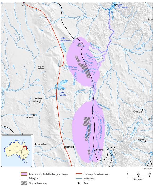
Figure 22 Zone of potential hydrological change for the Galilee subregion
Data: Bioregional Assessment Programme (Dataset 1), Geoscience Australia (Dataset 3)
3.3.1.3.1 Mine exclusion zone
The mine exclusion zone defined for the Galilee subregion is based on the open-cut mine footprints and the areas above underground longwall mines within the zone of potential hydrological change (Figure 22). The mine exclusion zone identifies areas within the zone that are within, or proximal to, areas of active mining, and where:
- modelled drawdowns from the regional-scale AEM are highly uncertain due to the very steep groundwater gradients that will exist at the mine working interface
- changes in drawdown are inevitable where the mine pits intersect the regional watertable
- other factors, such as physical removal of a wetland or creek, may have a larger impact on a landscape class than the predicted decrease in groundwater level
- impacts are predominantly site scale, and assumed to be adequately addressed through existing development approval processes, and hence not the primary focus of BAs.
The modelled estimates of drawdown in the mine exclusion zone are considered unreliable for use in the receptor impact modelling. In most cases, the areas underlain by the mine exclusion zone will have a consistent 10 m of drawdown due to the implementation of the mining activity upon the uppermost aquifer in the AEM for the Galilee subregion (companion product 2.6.2 (Peeters et al., 2018)). In total, the mine exclusion zone within the zone of potential hydrological change (which includes the footprints of all seven of the proposed coal mines modelled in this BA) covers an area of 986 km2.
In the impacts on landscape classes and assets sections (Section 3.4 and Section 3.5, respectively), the initial rule-out assessment summarises what is in the zone of potential hydrological change and, within that, what is in the mine exclusion zone. For landscape classes and assets that have a groundwater dependency, lengths and areas were differentiated by attribute class for areas within the zone of potential hydrological change, but no differentiation by attribute class was undertaken for such features in the mine exclusion zone.
3.3.1.3.2 Reporting areas
The zone of potential hydrological change has two discrete drawdown areas that correspond to the main areas potentially impacted due to additional coal resource development. Two separate reporting areas, which encompass the drawdown and potentially impacted surface water network associated with distinct mining clusters (north and south), have been defined to summarise results (Figure 22). In the Belyando river basin, the two groundwater drawdown areas are connected by the surface water zone of potential hydrological change. This means that results reported for the northern part of the zone may include some hydrological changes that have propagated from further upstream, thereby reflecting cumulative hydrological impacts across the zone (Table 10).
Table 10 Reporting areas and modelled additional coal resource development
|
Reporting area |
Additional coal resource development (modelled) |
Comments |
|---|---|---|
|
Northern |
Carmichael, China Stone, Hyde Park |
Includes all modelled areas of potential impact downstream of surface water model node 44, extending along reaches of the Belyando and Suttor rivers to Lake Dalrymple (Burdekin Falls Dam) |
|
Southern |
South Galilee, China First, Alpha, Kevin’s Corner |
Restricted to the area of the southern groundwater zone, upstream of surface water model node 44 (Figure 12) |
3.3.1.3.3 Presentation of surface water changes
The seven coal mines that are the focus of the numerical modelling for this BA are clustered at the central-eastern margin of the Galilee Basin. The mines are aligned along a north-trending axis that extends for nearly 250 km from the southern-most mine (South Galilee) to the northern-most mine (Hyde Park). Within this area are the edges of several distinct boundaries developed during the course of the BA for the Galilee subregion, including the respective boundaries for the subregion, assessment extent and zone of potential hydrological change (Figure 23). One consequence of having multiple proximal boundaries in this area is that it is very difficult to clearly display node and interpolated surface water modelling results (i.e. on maps) along much of the stream network, especially at the scale required to display the entire surface water modelling domain.
To overcome what would otherwise appear as a selection of cluttered and hard-to-read surface water maps, the various administrative boundaries that occur in this area are deliberately not included on all of the surface water maps presented in this product. Removing these boundaries, several of which also overlap with each other, means that the critical surface water modelling results at individual nodes, as well as the adjacent interpolated stream reaches, are more clearly displayed. To put these results into the context of the various boundary locations, readers are advised to visually cross-check locations with the various boundaries as depicted in Figure 23.
ACRD = additional coal resource development
