3.2.5.1 Ecosystems
Within BAs the relative level of risk to ecosystems and ecological assets within the zone of potential hydrological change is categorised to assist the rule-out process and help identify where further local-scale assessment may be required. In the context of water-dependent ecosystems (as represented by landscape groups), three levels of relative risk due to additional coal resource development are here defined, based on the combined outputs of relevant hydrological modelling and receptor impact modelling (see product 2.7 for the Galilee subregion (Ickowicz et al., 2018) for more information on the receptor impact models). The three risk categories in BAs relevant to landscape groups are:
- ‘more at risk of ecological and hydrological changes’
- ‘at some risk of ecological and hydrological changes’
- ‘at minimal risk of ecological and hydrological changes’.
Assessment units that overlap with a landscape group for which receptor impact modelling has been undertaken may be categorised under one of these three classes if the modelled hydrological changes (i.e. as represented by the relevant groundwater and/or surface water hydrological response variables) result in ecological changes that lie within defined risk thresholds. These thresholds have been chosen by the Assessment teams based on multiple lines of evidence and are defined using relevant receptor impact variables. For example, the defined risk thresholds selected for the ‘High-flow macroinvertebrate’ receptor impact model applied to the ‘Streams, non-GDE’ landscape group are:
- The lower risk threshold is defined as a decrease of greater than 10 mayfly nymphs per m2
- The upper risk threshold is defined as a decrease of greater than 20 mayfly nymphs per m2.
Thus, any assessment units that exceed the lower risk threshold (but not the upper risk threshold) for a landscape group are defined as being ‘at some risk of ecological and hydrological changes’. If the upper risk threshold is exceeded, then these assessment units are defined as being ‘more at risk of ecological and hydrological changes’. Importantly, these risk definitions highlight areas relative to the rest of that landscape group, and thus flag locations where any future local-scale assessment is best prioritised. To aid this interpretation, composite risk maps are provided in Section 3.4 for each of the landscape groups assessed through receptor impact modelling in the BA of the Galilee subregion. The overall risk categories depicted on these maps represent the highest level of relative risk estimated for each assessment unit. The specific application of this risk categorisation approach for the four landscape groups for which receptor impact models were built for the Galilee subregion is outlined in Section 3.4 (the four landscape groups are: ‘Streams, GDE’, ‘Streams, non-GDE’, ‘Floodplain, terrestrial GDE’ and ‘Non-floodplain, terrestrial GDE’).
3.2.5.2 Ecological water-dependent assets
Categorising risk for assets follows a similar general approach as for ecosystems, but does not incorporate ecological modelling results as receptor impact models were developed only for some of the landscape groups in the BA of the Galilee subregion. Although it is technically possible to develop receptor impact models for individual ecological assets, the total number of such assets within the zone (241 ecological water-dependent assets occur in the zone of potential hydrological change for the Galilee subregion, as explained in Section 3.5.2) precluded the development of individual asset-scale receptor impact models due to the operational constraints of the BA. As a result, composite risk maps as presented for the landscape groups (Section 3.4) were not developed for assets.
Consequently, there is only a single risk category used to highlight those assets that are considered ‘more at risk of hydrological changes’. Assessment units that overlap with the spatial distribution of an asset are considered ‘more at risk’ based on the degree of hydrological changes that exceed the thresholds of risk defined by the Assessment team (based on their expert opinion and using multiple lines of available evidence). For example, assets that intersect with the ‘Streams, GDE’, ‘Floodplain, terrestrial GDE’ and ‘Non-floodplain, terrestrial GDE’ landscape groups were deemed ‘more at risk’ if the assessment unit in which they occur has an increase in drawdown exceeding 2 m. Drawdown is used for these landscape groups as it is a hydrological response variable that is identified as important through the qualitative mathematical modelling (see Ickowicz et al. (2018) for further information about the qualitative mathematical modelling results for these landscape groups). For other landscape groups, other hydrological response variables are used. The identification of assets considered ‘more at risk of hydrological changes’ in the Galilee subregion’s zone of potential hydrological change is outlined in Section 3.5.2.5.
The risk categorisation approach and associated terminology used for assets is shown in Figure 19. Although a more detailed investigation of risk to each asset in the zone was not possible for this BA, Section 3.5.2.7 provides a case study for an individual ecological asset (the ‘potential distribution of Black Ironbox’). This example illustrates how multiple lines of evidence, including the outputs of ecosystem-scale receptor impact models for relevant landscape groups, can be integrated with existing knowledge to develop a more refined assessment of potential impacts on, and risks to, individual assets.
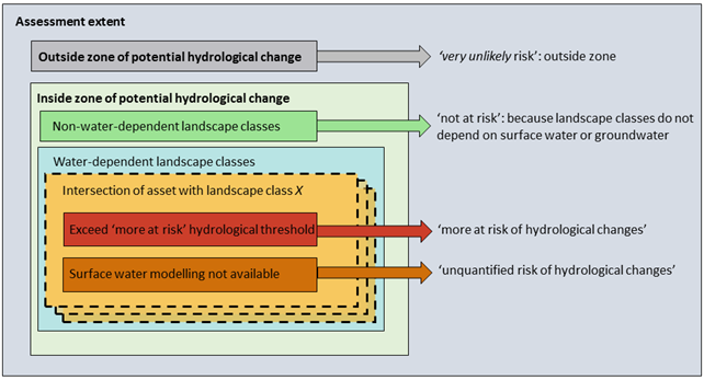
Figure 19 Risk categorisation terminology for ecological water-dependent assets
