The objective of the Bioregional Assessment Programme is to understand and predict regional-scale cumulative impacts on water resources and water-dependent assets caused by coal resource developments in Australia's major coal-bearing sedimentary basins. In particular, the assessments identify areas where water resources and water-dependent assets are very unlikely to be impacted (with a less than 5% chance), or are potentially impacted. Governments, industry and the community can then focus on these areas that are potentially impacted and apply further local-scale modelling when making regulatory, water management and planning decisions.
This impact and risk analysis considers only biophysical consequences, such as changes in hydrology or ecology; fully evaluating consequences requires value judgments and non-scientific information that is beyond the scope of BAs. A full risk assessment (with risk evaluation and risk treatment) was not conducted as part of BAs, although the information presented in this product could be used to provide critical input into such a broader assessment in the future.
The purpose of this section is to highlight important design choices that have steered the direction of the BA for the Galilee subregion and culminated in this impact and risk analysis. The following six themes are briefly covered:
- choice of modelled futures
- focus on water quantity and availability
- assessment of regional-scale cumulative developments
- focus on predictive uncertainty
- a landscape classification
- ruling out potential impacts.
Further details about the design choices are provided in companion submethodology M10 (as listed in Table 1) for analysing impacts and risks (Henderson et al., 2018).
3.1.2.1 Choice of modelled futures
A BA is a regional analysis that compares two potential futures of coal resource development. In BAs, the term ‘coal resource development’ specifically includes coal mining (both open-cut and underground) as well as CSG extraction. Other forms of coal-related development activity, such as underground coal gasification, were not within the scope of the assessment.
The two futures considered in the BA for the Galilee subregion are:
- baseline coal resource development (baseline): a future that includes all coal mines and CSG fields that are commercially producing as of December 2012
- coal resource development pathway (CRDP): a future that includes all coal mines and CSG fields that are in the baseline as well as those that are expected to begin commercial production after December 2012.
The difference in results between CRDP and baseline is the change that is primarily reported in a BA. This change is due to the additional coal resource development – all coal mines and CSG fields (including expansions of baseline operations) that are expected to begin commercial production after December 2012. Importantly, the focus of the BA is on the suite of coal resource developments defined for both the baseline and the CRDP, based on the development time frames (i.e. mining schedules) identified when these two futures were ‘locked-in’. Once the complete suite of operations and time frames are defined for the BA the CRDP is not revisited or changed. Likewise, there are no separate, stand-alone modelling runs done to evaluate impacts of individual developments (i.e. the focus is always on the suite of operations at the regional-scale of the BA, rather than on any individual mine or CSG development).
As documented in companion product 1.2 for the Galilee subregion (Lewis et al., 2014) there were no coal mines or CSG fields in commercial production as of December 2012. Consequently, for the purposes of the BA for the Galilee subregion, the modelled baseline does not include any coal resource developments.
In contrast to the baseline, the CRDP for the Galilee subregion has 17 proposed new coal and CSG resource development projects (Table 3). Most of the developments in the CRDP are for new large-scale coal mines that target thermal coal resources hosted within upper Permian strata, such as the Betts Creek beds, Bandanna Formation and the Colinlea Sandstone (companion product 1.1 for the Galilee subregion (Evans et al., 2014)). These proposed coal mines mainly occur close to the northern and eastern margins of the geological Galilee Basin (Figure 6), where the coal-bearing Permian rock layers are relatively close to the surface (i.e. generally within several hundred metres), and are thus amenable to future mining development.
On the basis of information available as of December 2014, the proposed coal mining operations in the Galilee CRDP are:
- three open-cut coal mines (Alpha, Hyde Park and Blackall)
- two underground coal mines (Alpha West and Hughenden)
- five combined open-cut and underground coal mining operations (Carmichael, China First, China Stone, Kevin’s Corner and South Galilee)
- four coal mines of currently uncertain type due to lack of relevant information (Clyde Park, Milray, Pentland and West Pentland –potentially these may be developed as combined open-cut and underground mining operations).
There are also three early-stage CSG projects included in the CRDP (Glenaras Gas Project, Gunn Project and Blue Energy’s CSG project in Exploration Permit for Petroleum (EPP) 813). The locations of the proposed coal mines and CSG developments in the CRDP are shown in Figure 6. Further information about each project in the CRDP, including reasons for their inclusion, is in companion product 2.3 for the Galilee subregion (Evans et al., 2018).
Table 3 Coal resource development pathway for the Galilee subregion
Of the 17 coal resource developments in the CRDP, there are seven coal mines that were considered by the Assessment team to have sufficient information available (at the time when the CRDP was determined in December 2014) to be quantitatively assessed for this BA through hydrological modelling. These proposed coal mines are: Alpha, Carmichael, China First, China Stone, Hyde Park, Kevin’s Corner and South Galilee. These are the most advanced mining developments in the Galilee subregion in terms of progressing through the various environmental and mining-related approvals processes that apply under relevant Queensland and Australian Government legislation. Most of these proposed mines have previously undertaken planning and development studies to determine optimal mining and production methods, and much of this information is publicly available as part of their respective environmental impact statements. Consequently, these seven proposed coal mines are the main focus of the quantitative impact and risk analysis undertaken for the Galilee subregion (as reported in this product).
The remaining seven coal mining developments and the three proposed CSG projects are also included in the Galilee CRDP, but these all lack sufficient information about the nature of any future commercial operations to specifically include them in the hydrological modelling. Instead, a qualitative analysis of potential impacts and risks from these less advanced coal resource developments is in Section 3.6.
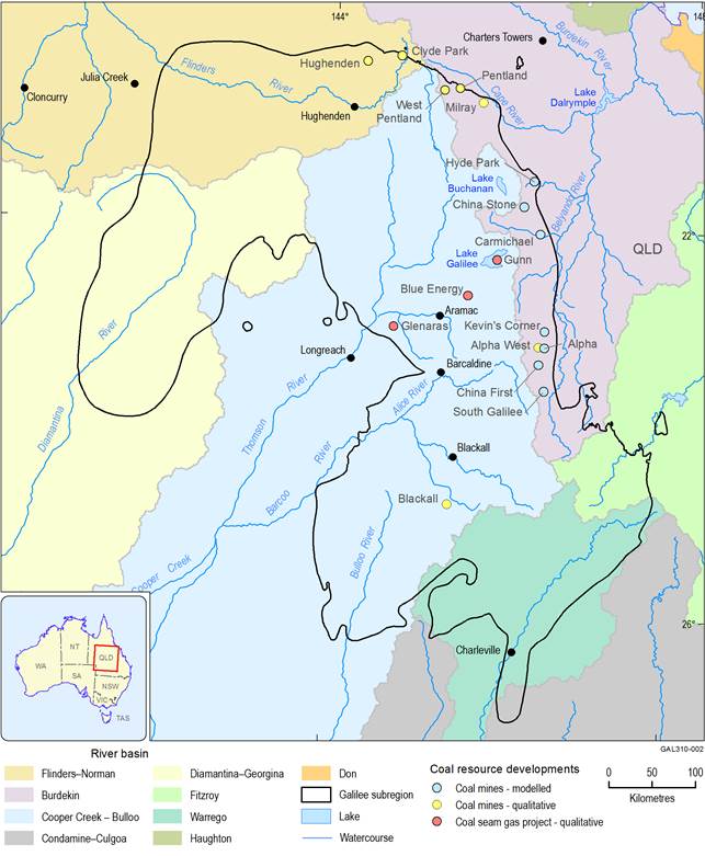
Figure 6 Coal resource developments and river basins in the Galilee subregion
Data: Bureau of Meteorology (Dataset 4, Dataset 5, Dataset 6); Geoscience Australia (Dataset 7); Geological Survey of Queensland (Dataset 8); Bioregional Assessment Programme (Dataset 9)
The CRDP is the most likely future, based on the analysis and expert judgment of the Assessment team in consultation with coal and gas industry representatives, and experts from various Queensland and Australian Government agencies. The BA approach for developing the CRDP is outlined in companion submethodology M04 (as listed in Table 1) for developing a coal resource development pathway (Lewis, 2014). The CRDP was finalised (i.e. ‘locked-in’) for the Galilee subregion based on information available as of December 2014 (companion product 2.3 (Evans et al., 2018), Section 2.3.4.1) to allow the hydrological numerical modelling to commence. In reality, developments in the CRDP may ultimately be implemented in different ways (e.g. changes to estimated timing of construction or production phases), or specific circumstances may change (e.g. a proponent may withdraw their development plans for some reason). This reflects the dynamic nature of resource investment decision making, related to diverse economic, political or social factors. Consequently, the Galilee CRDP needs to be viewed as an indicative future that highlights potential changes for water resources and water-dependent assets that may need to be considered further in local analyses or via approval conditions required by regulators. Equally as important, the CRDP plays a role in identifying where potential impacts to water resources and water-dependent assets are very unlikely.
Factors such as climate change and land use (such as agriculture) were held constant between the two futures. Although the future climate and/or land use may differ from those assumed in BAs, the effect of this choice is likely small because the focus of BAs is on reporting the difference in results between the CRDP and baseline.
The scope of the BAs is on potential impacts to water resources and water-dependent assets that are attributable to the additional coal resource development. In the case of the BA for the Galilee subregion, the absence of any baseline coal mines or CSG fields means that the CRDP only comprises additional coal resource developments. Hence, there are no baseline impacts attributable to coal resource development in the Galilee subregion. The clear focus of the BA for the Galilee subregion is directed towards understanding the potential for cumulative hydrological impacts, due to the multiple large-scale coal mines slated for future development along a north-trending fairway about 250 km long, near the eastern margin of the central Galilee Basin.
3.1.2.2 Focus on water quantity and availability
BAs focus solely on water-related impacts, and specifically those related to water quantity and availability. Potential water quality hazards were identified through the comprehensive hazard analysis undertaken as part of conceptual modelling for the Galilee subregion (companion product 2.3 (Evans et al., 2018)). However, the further analysis of these hazards, as determined by the scope of BAs, was limited to those that potentially affect salinity, and these are only addressed qualitatively (see Section 3.3.4).
BAs are mainly concerned with surface water and groundwater effects that may accumulate, either over extended time frames or as a result of multiple coal resource developments. Both of these factors are relevant for the BA for the Galilee subregion. These effects typically correspond to changes in surface water and groundwater that are sustained over long periods of time, sometimes decades or longer, and which may create the potential for flow-on effects through the wider hydrological system. As an example, consider the potential for drawdown in the watertable aquifer (due to dewatering associated with multiple coal mining operations) to subsequently affect the volume and timing of any baseflow contribution to connected streams. In this example, the prolonged effects of the hydrological changes to the watertable aquifer may also lead to long-term changes in surface water – groundwater interactions.
Many activities related to coal resource development may cause local or on-site changes to surface water or groundwater, for example, on-site compaction, settlement and contouring of open-cut pit backfill, or the spillage or disposal of various compounds (such as diesel, oils, muds, or drill cuttings). These types of hydrological changes are not considered explicitly in BAs because they are assumed to be adequately managed by site-based risk management and mitigation procedures, and are also unlikely to create potential cumulative impacts. Impacts and risks associated with water quality attributes other than salinity that are potentially affected by coal resource development are identified (see Section 2.3.5 in companion product 2.3 (Evans et al., 2018), but are not analysed further in this BA.
3.1.2.3 Assessment of regional-scale cumulative developments
BAs are designed to analyse the cumulative impacts of coal resource developments at a regional scale, and not to focus specifically on individual mines or CSG operations. The CRDP for the Galilee subregion includes a suite of proposed coal resource developments, the potential hydrological impacts of which may overlap to varying degrees in both time and space. This is particularly likely given the proximity of many proposed coal mines in the central-eastern part of the subregion, and the similarity in timing of their current development schedules. The main focus of the BAs allows for the prediction and understanding of the cumulative hydrological changes and potential impacts of those developments on surface water, groundwater and water-dependent assets. In some cases, the spatial or temporal alignment of certain coal mines may allow for some attribution of potential hydrological effects to individual operations, but that occurs only because of such alignment rather than by design.
Importantly, the regional-scale nature of the BAs means that results of the impact and risk analysis reported in this product do not replace the need for detailed site- or project-specific investigations that are currently required under existing state and national legislation. Further, the regional-scale BA results should not be used to invalidate existing site-specific modelling or impact assessments, nor pre-empt results of future investigations that may be required, for example, by various Queensland Government agencies. The hydrological and ecological system modelling undertaken for this BA are appropriate for assessing the potential impacts on and risks to water resources and water-dependent assets at the ‘whole-of-basin’ scale. However, the modelling done by each mining proponent for individual coal resource developments (e.g. as reported in environmental impact statements) occurs at a much finer scale and is able to more accurately capture local data and information. For example, groundwater modelling at the scale of individual coal mines will use more detailed (e.g. higher resolution) hydrogeological data and conceptualisations than is possible to use when modelling groundwater systems at the scale of the entire Galilee Basin. Consequently, modelling outcomes reported from such detailed mine-specific studies may yield differing results to those from the BAs, due to the variations in the scale of the modelling and the enhanced representation of local systems and processes in the more detailed models. However, as a wide range and combination of potential model parameter values are considered in the modelling done for this BA, it is expected that the range of predicted modelling outcomes will encompass the results from site-specific studies.
3.1.2.4 Focus on predictive uncertainty
In BAs, parameter uncertainty was considered as fully as possible when predicting hydrological outcomes (i.e. changes to surface water or groundwater) and ecological outcomes (i.e. changes to ecologically relevant receptor impact variables). For example, groundwater models were run many thousands of times using a wide range of plausible input parameters for the main hydraulic properties, such as the hydraulic conductivity and storage coefficients of all modelled hydrogeological layers (see companion product 2.6.2 for the Galilee subregion (Peeters et al., 2018). This differs from the traditional deterministic approach used more routinely for groundwater (Barnett et al., 2012) and surface water modelling and is driven by the risk analysis focus of BAs.
The density of reliable physical observation data is sparse in the Galilee subregion, meaning that the BA modelling results may not accurately represent some local conditions. However, the models do consistently represent the risk and uncertainty at all sites through probability distributions of possible hydrological changes. The area, depth, timing and assumed pumping rates of each mine largely determine the spatial variation. Additionally, the lack of detail about the physical environment at any given point in the assessment extent, as well as the absence of information about how the environment may change through time, defines the uncertainty.
Given the wide range of plausible input parameters used in the regional modelling, the hydrological changes due to additional coal resource development at any given location can be assumed to lie within the distribution of modelled changes. This assumption may not be valid near mines though, where potentially steep hydraulic gradients at the mine interface are poorly resolved in the regional groundwater model. Thus, the results from the hydrological modelling and uncertainty analysis are not reported for these mining areas, and they are also excluded from the ecological analysis for this reason; that is, the receptor impact models are not applied to landscape groups that occur within the areas defined as mine exclusion zones (further information about mine exclusion zones is in Section 3.3.1.3.1). Where the BA regional-scale analysis identifies an area as ‘at risk’ of large hydrological changes and there are potential impacts on ecological, economic and/or sociocultural values, local scale information may be necessary to constrain the predictive uncertainty to something more representative of local conditions, and more appropriate for informing specific management responses.
The quantitative representation of the predictive uncertainty through probability distributions allows BAs to consider the likelihood of impacts with a specified magnitude and underpins the impact and risk analysis. Sources of uncertainty that could not be quantified through numerical modelling were considered qualitatively, and are reported for both groundwater modelling (companion product 2.6.2 (Peeters et al., 2018)) and surface water modelling (companion product 2.6.1 (Karim et al., 2018)).
3.1.2.5 A landscape classification
The Galilee subregion comprises diverse landscapes with a wide range of human and ecological systems, and these may be discrete, overlapping or variably integrated. Because of this complexity, a direct analysis of each and every locality, or water-dependent asset, in the landscape is not possible. Instead, conceptual abstraction and a system-level classification were used to manage the challenges of this multi-dimensional task.
A set of landscape classes were defined for the Galilee subregion that are similar in their physical, biological and hydrological characteristics. This reduced the landscape complexity of the subregion and is an appropriate tool for a regional-scale assessment. For BA purposes, a landscape class is an ecosystem with characteristics that are expected to respond similarly to changes in groundwater and/or surface water due to coal resource development. There is expected to be less heterogeneity in the hydrological response within a landscape class than between different landscape classes.
The landscape classification characterises the landscape and focuses on the key processes, functions and interactions for the individual landscape classes. The landscape classification for the Galilee subregion built on existing and well-accepted classification schemes and is described in detail in Section 2.3.3 of companion product 2.3 for the Galilee subregion (Evans et al., 2018). Landscape classes occur across the entire assessment extent of the Galilee subregion and do not overlap. The use of this landscape classification meant that the analysis of impacts and risks could be suitably focused on those landscape classes that are water dependent.
The assessment of impacts on and risks to water-dependent ecological assets relied heavily on the landscape classification. Potential impacts to individual assets were assessed via their constituent landscape classes. For each of those landscape classes, the assessment was based on the qualitative mathematical models for those landscape classes and the indicators of hydrological change or ecosystem change identified as important for that landscape class. This is more fully explained in Section 3.4 and Section 3.5.
3.1.2.6 Ruling out potential impacts
An important outcome of this BA was to identify areas of the Galilee subregion that are not likely to be impacted due to additional coal resource development. Potential impacts were ruled out where possible, both spatially and in terms of specific groundwater or surface water effects, in order to concentrate the analysis on areas where potential impacts have a higher probability of occurring. This process started with identifying a preliminary assessment extent (PAE) for the subregion that is a conservative spatial boundary, encompassing areas of potential impact based on the catalogue of potential coal resource developments within the subregion (companion product 1.2 for the Galilee subregion (Lewis et al., 2014)). The PAE for the Galilee subregion is approximately 612,000 km2, and the methods used to develop it are reported in companion product 1.3 for the Galilee subregion (Sparrow et al., 2015). The PAE is where assessment effort was preferentially focused for this BA, and was an important boundary in collating water-dependent assets, creating landscape classes to summarise surface ecosystems, and constructing numerical surface water and groundwater models.
For the purpose of reporting the impact and risk analysis for the Galilee subregion, the PAE is referred to hereafter simply as the ‘assessment extent’. The size and shape of the Galilee subregion assessment extent is the same as the PAE, but this simple change in terminology reflects the more advanced stage of the BA that is reported in this product.
Potential impacts due to additional coal resource development in the Galilee subregion were ruled out using a zone of potential hydrological change. This zone was defined using probabilities of exceeding thresholds in multiple hydrological response variables, based on outputs from the groundwater and surface water models. A key role of the zone of potential hydrological change is to identify landscape classes that require further investigation through qualitative mathematical modelling and receptor impact modelling. Equally as important, this logical and consistently applied process effectively ruled out landscape classes or water-dependent assets where potential impacts due to additional coal resource development are very unlikely to occur (i.e. less than 5% chance of change in a relevant hydrological response variable).
