For the Hunter subregion, the modelling suite includes the AWRA-L landscape model (Viney et al., 2015) to calculate the surface runoff to streams; the Multiphysics Object-Oriented Simulation Environment (MOOSE) groundwater model to simulate watertables and baseflows (MOOSE, 2016; Herron et al., 2018b); and the AWRA-R river routing model (Dutta et al., 2015) by which river flows are propagated downstream. The individual models have different spatial and temporal resolution which requires a set of customised processing steps to upscale or downscale model data to allow the models to be linked.
Figure 3 illustrates the model sequencing, parameters exchanged between models and outputs generated at model nodes to inform the receptor impact modelling. The MOOSE, AWRA-L and AWRA-R baseline runs simulate the changes arising from coal mines that were commercially producing coal as at December 2012. The corresponding CRDP runs simulate the combined changes arising from the baseline coal resource development and those expected to begin commercial production after 2012.
The landscape model, AWRA-L, delivers surface runoff to the river model, AWRA-R. This flux includes the effects of any coal development on surface runoff generation. AWRA-R also receives information on changes to baseflow generation associated with the coal resource developments from the groundwater model. The differences in streamflow between coal resource developments in the CRDP and baseline are obtained from the output of AWRA-R.
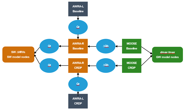
Figure 3 Model sequence for the Hunter subregion
AWRA = Australian Water Resources Assessment; AWRA-L = landscape model; AWRA-R = river model; CRDP = coal resource development pathway; dmax = maximum drawdown; GW = groundwater; DHRV = change in hydrological response variable; MOOSE = groundwater model; DQb = change in baseflow relative to no development baseflow; Qr = surface runoff; Qt = total streamflow; SW = surface water; tmax = year of maximum change
