The basal stratigraphic sequence within the Galilee Basin is the Late Carboniferous to Early Permian Joe Joe Group, deposited from about 320 to 280 million years ago (Ma). The Joe Joe Group consists of four main stratigraphic units, namely the Lake Galilee Sandstone (lowermost), Jericho Formation, Jochmus Formation and the Aramac Coal Measures (Figure 4). The stratigraphic and areal extent of these formations varies across the Galilee Basin, with the maximum known thickness of the Joe Joe Group being 1781 m (Lake Galilee 1 petroleum exploration well; GA and ASC, 2014). Following the cessation of deposition in the Late Permian, much of the upper part of the Joe Joe Group (including the Aramac Coal Measures) was removed by erosion in the Middle to Late Permian.
The main coal-bearing unit in the basal group of the Galilee Basin is the Aramac Coal Measures. Minor coal occurs sporadically in some of the other units within the Joe Joe Group but it is mostly thin and discontinuous (Wells, 1989). Based on analysis of fossilised spore and pollen assemblages (palynology), the Aramac Coal Measures are stratigraphically equivalent to the Reids Dome beds in the central and south-western Bowen Basin, and are thus the oldest coals in the Galilee Basin. These are commonly referred to as Group I coals in the terminology of Queensland’s Permian coal resources (Mutton, 2003). The Aramac Coal Measures are an interbedded sedimentary sequence of sandstone (about 49%), siltstone and mudstone (40%), and coal (about 11%) (Wells, 1989). Scott et al. (1995) suggested that the lower parts of the Aramac Coal Measures are predominantly sandstone with only minor coal and mudstone, whereas the upper part consists mainly of sandstone with subordinate coal. The maximum percentage of coal known from the formation is about 20%, based on interpretation of drill cuttings and down-hole geophysical logs.
The coals in the Aramac Coal Measures are mostly grey to black, brittle and predominantly dull, although minor bright bands have been described, for example, by AGL Energy Limited (AGL) (2009) in their well completion report for CSG exploration well Glenaras 6. Based on coal sample analyses from various petroleum exploration wells, the Aramac Coal Measures contain high volatile bituminous coal with a mean reflectance (Rv, max) of 0.6 to 0.8%. Maximum vitrinite reflectance of 1.1% has been measured in deep coal seams from about 1700 m depth below surface (Smith, 2013). Analysis of coal sample R3382 (air dried) recovered from depth of 1111 m below surface in the Geological Survey of Queensland’s Longreach 1-1B stratigraphic drill-hole reported 56.8% fixed carbon, 39.0% volatile matter, 3.4% moisture and 0.8% ash (Green et al., 1991).
The Aramac Coal Measures have a restricted areal distribution in the Galilee Basin (Figure 3), and are mainly known from petroleum exploration wells drilled in the central and western parts of the basin. The unit is not known to occur in the southern Galilee Basin, that is, south of the geological Barcaldine Ridge (Figure 5). Several interpretations have suggested that the distribution of the Aramac Coal Measures has been largely controlled by structural movements at the time of deposition, with thickest coal seams formed in fault-controlled grabens and half-grabens (Scott and Hawkins, 1992; Scott et al., 1995). The thickest stratigraphic intersections of the Aramac Coal Measures in petroleum wells have mainly occurred in the Aramac Trough and the Lovelle Depression (Figure 5). These typically range from about 100 m thick to a maximum of 271 m in Lovelle Downs 1. An unknown thickness of this formation was removed by erosion during the Middle to Late Permian.
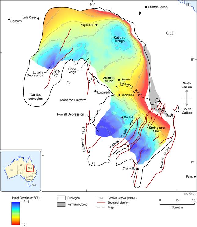
Figure 5 Main geological structures and depositional centres in the Galilee Basin
Source data: the top of Permian strata contours are derived from data in Bradshaw et al. (2009). Although Permian rocks exist throughout the basin, not all were shown in the mapping presented in Bradshaw et al. (2009).
mBGL – metres below ground level
The Aramac Coal Measures are buried too deeply (mostly in excess of 600 m) throughout the Galilee Basin for coal mining development to be economically viable (Durie et al., 1992). However, they have been targeted by some exploration companies for their coal seam gas (CSG) potential, usually as a combined CSG target with overlying Late Permian coal-bearing strata. For example, this exploration approach has been taken by AGL in exploration permit for petroleum (EPP) 529 in the Aramac Trough. Further information on the Joe Joe Group is provided in product 1.1 for the Galilee subregion (Evans et al., 2014).
