Major surface water systems in the Hunter subregion are rivers, lakes, reservoirs, swamps, and surface water infrastructure such as dams (Figure 38). The Hunter River includes eight major tributaries: Moonan Brook, Stewarts Brook, Paterson River, Williams River, Pages Creek, Pages River, Goulburn River, and Wollombi Brook. The Macquarie Tuggerah catchment includes three major tributaries: Dora Creek, Wyong River and Ourimbah Creek. The Quirindi Creek flows through the northern part of the subregion. The lower Karuah River flows through the eastern part of the subregion.
1.1.5.1.1 Surface drainage networks
The biggest river in this subregion is the Hunter River, a major river in NSW, Australia. It rises in the Liverpool Range, and flows generally south and then east before flowing into Lake Glenbawn. It then flows south-west and then east-south-east before reaching its mouth on the Tasman Sea at Newcastle. The Hunter River is joined by ten tributaries upstream of Lake Glenbawn, and a further 31 tributaries downstream of the reservoir. Its eight main tributaries include the Moonan Brook, Stewarts Brook, Paterson River, Williams River, Pages River, Pages Creek, Goulburn River, and Wollombi Brook (Table 12).
The Hunter River splits into two main channels from east of Hexham, separated by the Ramsar-protected Kooragang Wetlands. The southern arm of the river also creates Hexham Island, while the northern creates Smiths Island and flows into Fullerton Cove. The two channels converge at Walsh Point, reaching confluence with Throsby Creek adjacent to the Newcastle central business district, before reaching the river mouth.
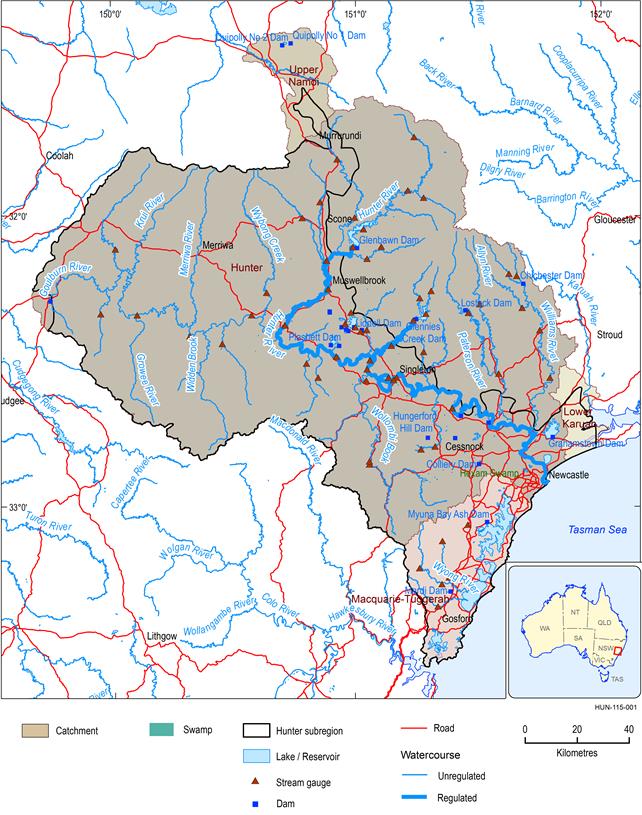
Figure 38 Surface drainage network and streamflow gauges within the Hunter subregion
The thick blue line shows regulated sections of the Hunter River, managed under the Hunter Regulated River Water Sharing Plan. The unregulated sections of the Hunter River above Glenbawn Dam are managed under the Hunter Unregulated Alluvial Water Sources Water Sharing Plan.
Data: Bureau of Meteorology (Dataset 1)
The Hunter River descends 1397 m over its 468 km course from the high upper reaches, through the Hunter Valley, and out to sea. The total Hunter river basin area is 21,437 km2.
The Macquarie Tuggerah basin is located in the NSW Central Coast and Lake Macquarie area directly south of the Hunter basin (Figure 38). The Macquarie Tuggerah basin covers an area of 1836 km2 and is bordered by a series of east flowing streams in the north, and the Sugarloaf Ranges to the north-west. The Hawkesbury River acts as a boundary to the south, while the Hunter Range separates this basin from the Mangrove Creek basin.
The Macquarie Tuggerah basin includes three major rivers, Dora Creek, Wyong River and Ourimbah Creek. Dora Creek runs south-east for 25 km to meet Lake Macquarie at the township of Dora Creek. The major tributaries of Dora Creek include Moran, Tobins, Jigadee, Blarney and Deep creeks. Wyong River runs south-east for 48 km to meet Tuggerah Lake at Tacoma. The Wyong River's major tributaries include Jilliby Jilliby and Cedar Brush creeks. Ourimbah Creek runs south-east for 31 km to meet Tuggerah Lake at Chittaway. Ourimbah Creek's major tributaries include Elliots, Bumbles, Toobys, and Bangalow creeks, which drain the southern-most corner of the subregion.
The Hunter subregion contains a part of the lower Karuah river basin. The Karuah River originates from the south-eastern slopes of the Gloucester Tops section of the Great Dividing Range, south‑west of Gloucester, flows generally south-east and south, and discharges into Port Stephens near the township of Karuah. The total length of the Karuah River is about 100 km. It has two major tributaries within the Hunter subregion: Chilcotts Creek with a length of 6.8 km and Colly Creek with a length of 6.4 km.
The Hunter subregion also contains a small part of the upper Namoi river basin, through which Quirindi Creek – a tributary of the Mooki river basin – flows. Quirindi Creek originates from Crawney Mountain at an elevation of 723 m, and flows into the Mooki River at an elevation of 299 m, dropping around 424 m over its 87.4 km length. Major tributaries of Quirindi Creek include Quipolly Creek, Kangaroo Creek, Basin Creek, and Back Creek.
Table 12 Catchment area for the main rivers and their main tributaries within the Hunter subregion
aDirection means the left or right side along the main rivers from upstream to downstream.
1.1.5.1.2 Surface water infrastructure
There are 23 dams within the Hunter subregion (Figure 38).The major dams in the Hunter river basin include Glenbawn Dam, Glennies Creek Dam, and Lostock Dam (NSW Government, 2014). The Glenbawn Dam is the largest, and is situated on the Hunter River about 14 km east of Scone, NSW. The purpose of the dam includes flood mitigation, hydro-electric power, irrigation, water supply and conservation. Its contribution reservoir is Lake Glenbawn. Construction of this dam commenced in 1947, and was completed in 1958. It was enlarged to triple its capacity in 1987. Its holding capacity is 750,000 ML, with a surface area of 2614 ha and a maximum depth of 85 m. The dam has an additional reserve capacity of 120,000 ML to hold floodwaters to reduce flooding in the river downstream. The Glennies Creek Dam on Glennies Creek is 39 km upstream from the junction with the Hunter River, and 25 km north of Singleton. It was commissioned because the Glenbawn Dam could no longer satisfy the water demand in the Hunter Valley by the 1970s. The building of Glennies Creek Dam began in August 1980, and was completed in June 1983. It has a water holding capacity of 283,000 ML, with a surface area of 1540 ha and a maximum depth of 56 m. The Lostock Dam is situated on the Paterson River, a major tributary of the Hunter River, about 65 km from Maitland. The construction of this dam began in 1969 and was completed in 1971. It has a water holding capacity of 20,000 ML, with a surface area of 220 ha and a maximum depth of 30 m. Comprehensive dam details can be found on the State Water website (State Water Corporation, 2014).
Chichester Dam and Grahamstown Dam are major drinking water suppliers for the Lower Hunter (Figure 38). The Chichester Dam is located north of Newcastle and within the Port Stephens Council local government area in the Lower Hunter Region of NSW. The dam's main purpose is as a drinking water supply dam (the largest in the Hunter river basin), and it provides about 40% of the potable water for the Lower Hunter Region. The Chichester Dam is located at the top of the Williams river basin, and as the second largest drinking water supply in the Hunter river basin, provides about 35% of the potable water of the Lower Hunter Region.
1.1.5.1.3 Flooding history
The Hunter River has a long history of floods, the most notable being the February 1955 event. This flood was one of the most devastating natural disasters in Australia’s history. Worst hit was the inland city of Maitland, and as a consequence, the 1955 Hunter Valley flood is often known as ‘The Maitland Flood’. A total of 25 lives were claimed during a week of flooding that washed away 58 homes and damaged 103 beyond repair. More than 5000 homes were flooded and about 15,000 people were evacuated. More details for this flood are available from the Bureau of Meteorology website (Bureau of Meteorology, 2014). Another major flood event in the Hunter Valley occurred on 8 and 9 June 2007 when an intense low pressure system caused devastating storms to hit the city of Newcastle and the Central Coast and led to major flooding throughout the Lower Hunter Region.
