The surface water system of the Hunter subregion has both regulated and unregulated portions. The Goulburn River in the west and Wollombi Brook to the south are unregulated and within the subregion, whereas Pages River and Moonan Brook above Glenbawn Dam are unregulated but outside the subregion. The Paterson, Allyn and Williams rivers all contribute to flow in the lower Hunter River below Greta. This is the tidally-influenced reach of the river and may also be influenced by regulation of flows from the Lostock and Chichester dams. Tidal influences are not represented in the river modelling undertaken in the bioregional assessment (BA) for the Hunter subregion.
The Hunter River from Glenbawn Dam to Newcastle, and Glennies Creek below Glennies Creek Dam, are classified as the regulated reaches of the Hunter River. These river reaches are subject to the NSW Government’s Hunter River Salinity Trading Scheme (HRSTS) in three blocks: the upper block of the Hunter River from Glenbawn Dam to Denman, middle block to the confluence with Glennies Creek and lower block to Singleton (shown in Figure 10). The HRSTS allows for discharge of saline water from mines and other industry during high-flow events so that river salinity at key monitoring locations is maintained below target levels. This has allowed miners, power generators and agricultural users to share the river as a resource without conflict, while sustaining economic development. The flow and salinity of the Hunter River in the regulated sections is carefully monitored and described in Section 1.1.5 of companion product 1.1 for the Hunter subregion (McVicar et al., 2015). River modelling in this BA includes simple rules for adding discharge to rivers under the scheme, but the river salinity is not explicitly modelled (see companion product 2.6.1 for the Hunter subregion (Zhang et al., 2018)).
A flow accumulation for surface water flows is shown in Figure 10 for rivers that originate in, or flow through, the Hunter subregion. The presentation of the data provides a visual impression of the variability of flow in the individual streams of the subregion, and the relativity of flow contributions from the various tributaries of the Hunter River. These data are not gauged river values but are from a climatological equilibrium model based on spatially variable long-term precipitation and potential evaporation. Flow in the Hunter River increases substantially after the confluence with the Goulburn River, increasing steadily as it flows east to the coast. Near the coast the flow appears to become much larger; however, this reach of the river is under tidal influence, which the modelling here does not take into account. Within the Macquarie‑Tuggerah lakes basin the Wyong River, Dora Creek and Ourimbah Creek are unregulated; however, the Mardi Dam storage is located in the lower part of the Wyong River.
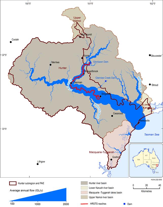
Long-term annual flow is estimated using water balance technique of Budyko (1974), as described by McVicar et al. (2015), and does not consider any impoundment or regulation of river flow. HRSTS is an acronym of Hunter River Salinity Trading Scheme.
Data: Bioregional Assessment Programme (Dataset 2, Dataset 3, Dataset 4)
