The detailed review of the geology of the southern Cooper Basin presented in this section builds on information presented in companion product 1.1 for the Cooper subregion (Smith et al., 2015b). New data incorporated herein includes stratigraphy and palynology from wells, reinterpreted geological models of the geological Cooper Basin (Hall et al., 2015), reinterpreted stratigraphy and geological history for the Weena Trough (discussed at the external conceptual modelling for causal pathways workshop). Further information on the geological history and unconventional gas resource potential for the Cooper Basin as a whole can be found in Hall et al. (2015).
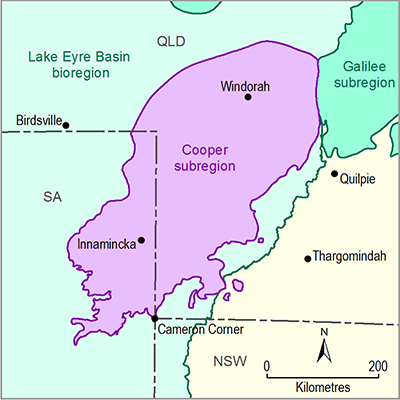
The Cooper Basin is an Upper Carboniferous – Middle Triassic basin in north-eastern SA and south-western Queensland (Figure 6). The geological basin covers approximately 130,000 km2 with a package of sedimentary rocks up to 2500 m thick at depths of between 1000 m and 4400 m (Smith et al., 2015b).
Exploration activity is currently focused on conventional oil and gas resources, as well as newly-identified unconventional hydrocarbon plays. These include the extensive basin-centred and tight gas accumulations in the Gidgealpa Group, CSG and deep dry CSG associated with the Patchawarra and Toolachee formations, as well as the less extensive shale gas plays in the Roseneath and Murteree shales (Goldstein et al., 2012; Menpes et al., 2012). As noted in Section 2.3.4, there is only one potential CSG-only resource identified in the subregion.
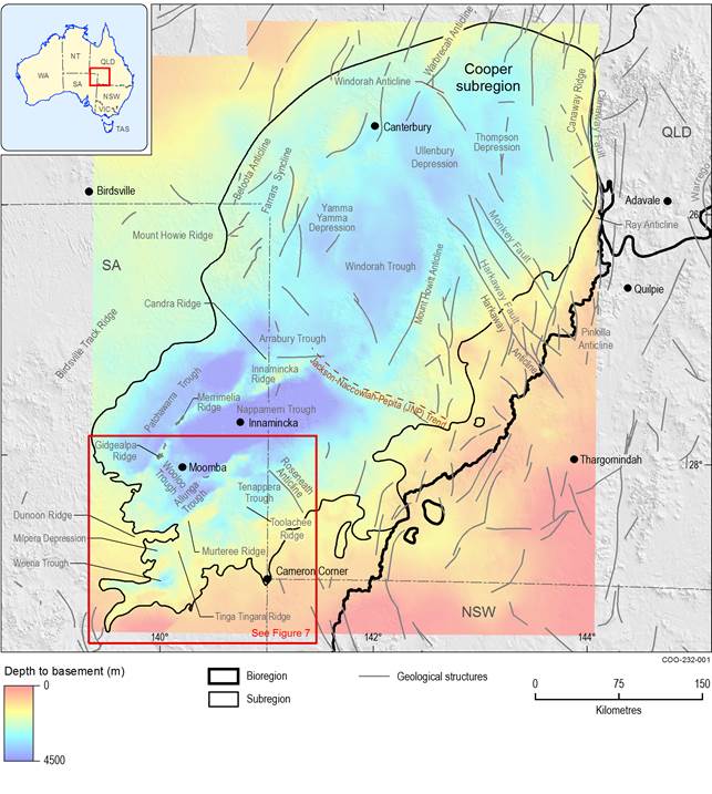
Figure 6 Cooper subregion showing depth to pre-Permian basement rocks and major structural features
Data: Geoscience Australia (Dataset 3), SA Department of State Development (Dataset 2), Hall et al (Dataset 13)
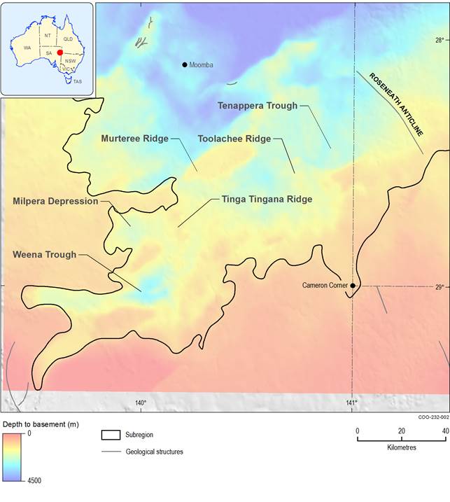
The Cooper Basin is divided into northern and southern areas, separated by the Jackson-Naccowlah-Pepita (JNP) Trend (Figure 6). These areas show different structural and sedimentary histories (Fergusson and Henderson, 2013; Heath, 1989). Depocentres south of the JNP Trend are generally deeper and contain a thicker and more stratigraphically complete Permian succession than those to the north (Fergusson and Henderson, 2013; Hill and Gravestock, 1995). The three major troughs in the south-west (Patchawarra, Nappamerri and Tenappera) are separated by the Gidgealpa-Merrimelia-Innamincka (GMI) and Murteree Ridges, which approximately trend north-east (Figure 6), parallel to the main depositional axis of the basin (Gravestock and Jensen-Schmidt, 1998). The Weena and Tenappera troughs on the southern margin of the basin are separated by the Tinga Tingana Ridge, which strikes north-south (Figure 7). In the northern Cooper Basin, the Permian succession is thinner than in the south, and the major depocentres, including the Windorah Trough and Ullenbury Depression, are generally less well defined (Draper, 2002; Fergusson and Henderson, 2013).
The southern Cooper Basin is a region marked by a series of troughs separated by ridges against which Permian sedimentary rocks thin or pinch out. The elongate and orthogonal alignment of troughs and ridges (Figure 6 and Figure 7) appears to reflect a structural fabric inherited from the underlying Warburton Basin as well as subsequent compressional tectonics; however, this basement relief is additionally modified by glacial scouring across the Cooper Basin (Boucher, 2001a).
Data: SA Department of State Development (Dataset 2), Hall et al (Dataset 13)
2.3.2.2.1 Basement to the southern Cooper Basin
The Cooper Basin unconformably overlies the sedimentary and volcanic rocks of the Cambrian – Ordovician Warburton Basin. The Warburton Basin consists of a sequence of marine sedimentary rocks deposited in a range of environments from the continental shelf to the deeper ocean (Fergusson and Henderson, 2013).
Devonian rocks are intersected in the Warrabin and Barrolka troughs, beneath the north-east trending Cooper Basin, and can be identified from seismic data (Draper et al., 2004; Fergusson and Henderson, 2013; Murray, 1994).
Numerous granite bodies intrude the Warburton Basin and underlie the Cooper Basin. Early Devonian granites occur beneath the southern Cooper Basin in Queensland and SA. Middle Carboniferous and early Permian granites are present beneath the Nappamerri Trough, and include the Big Lake Suite granodiorite (Gatehouse et al., 1995; Meixner et al., 2012).
The Warburton Basin sequence comprises siltstone and sandstone, with some reported volcanic rocks and dolostones. Fractures in brittle siltstones are capable of producing commercial oil and gas, for example Moolalla-1, Lycosa-1, Sturt-6, Sturt-7 and Challum-19 (Primary Industries and Resources SA, 2003). Sandstone porosity ranges from 5% to 20%, although permeability requires interconnected fracture networks. The porosity of volcanic rocks is up to 17% due to dissolution of feldspar and glasses, although, as for the sandstones, permeability requires interconnected fracture networks (Radke, 2009).
A thick alteration profile, however, exists on the basal unconformity of the Cooper Basin over the Warburton Basin. This profile probably developed in the late Carboniferous and early Permian. The profile developed as a result of pre-Cooper Basin weathering combined with low-temperature hydrothermal alteration. The profile generally exceeds 40 m but varies in thickness, thinning onto highs and ridges. Because of the alteration of feldspars to muscovite and illite, the alteration profile forms a seismically mappable semi-regional seal (Boucher, 2001b). As this regional alteration profile acts as an aquiclude, hydrogeological connectivity between the base of the Cooper Basin and the Warburton Basin is unlikely.
2.3.2.2.2 Stratigraphy of the Cooper Basin
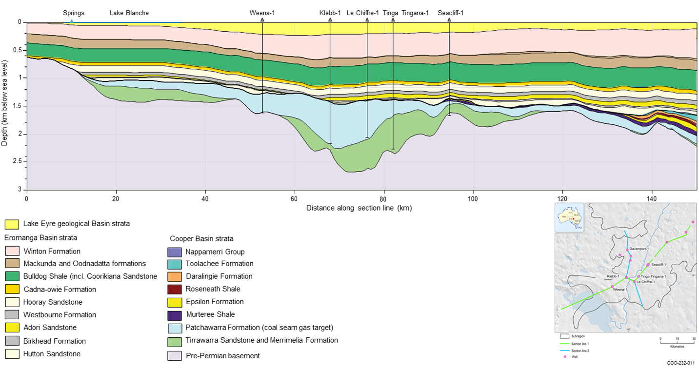
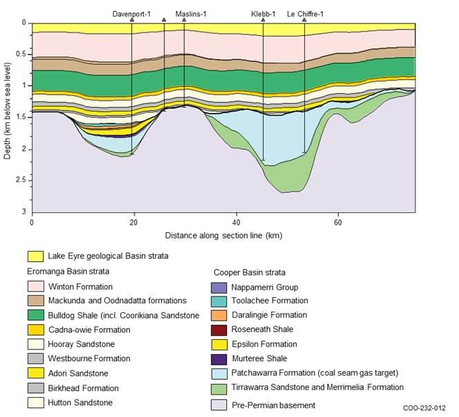
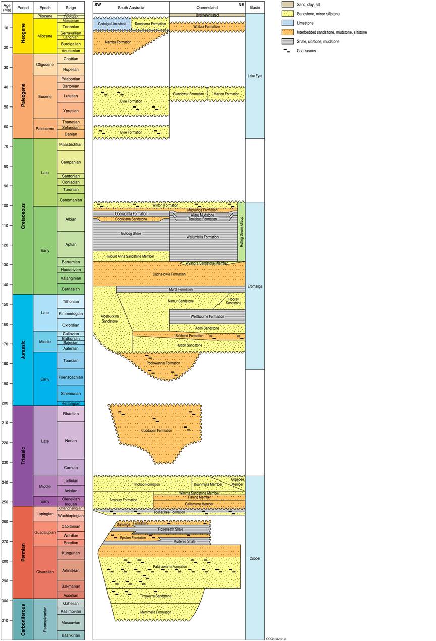
This section incorporates data and information made available following completion of companion product 1.1 for the Cooper subregion (Smith et al., 2015b). This includes incorporation of recent drilling results and reprocessing at basin scale of structure surfaces and isopachs (Hall et al., 2015), as well as a reinterpretation of the stratigraphy of the Weena Trough based on recent drilling and re-analysis of palynology (Morton, in review). The stacked basin architecture of the Cooper subregion is shown in the stratigraphic column (Figure 10) and cross-sections (Figure 8 and Figure 9). As noted previously, the focus of this work is the southern Cooper Basin.
The Patchawarra Formation is thicker in the Weena Trough and adjacent areas, and directly underlies Eromanga Basin units.
Data: Bioregional Assessment Programme (Dataset 11), Hall et al. (Dataset 13)
Data: Hall et al. (Dataset 13)
Figure 10 Stratigraphic column for the Cooper subregion
Data: Hall et al. (2015); Ransley et al. (2015); Smith et al. (2015b)
This figure has been optimised for printing on A3 paper (297 mm x 420 mm).
Cooper Basin
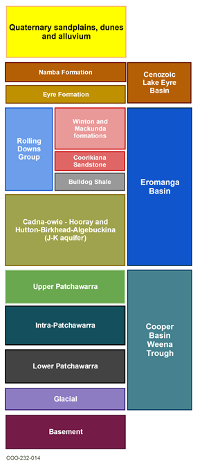
The recent stratigraphic reinterpretation by Morton (in review) on re-calibrated palynological ages in eastern Australian basins (Nicoll et al., 2015) has highlighted unique features of the Cooper Basin stratigraphy in the Weena Trough. A revised stratigraphy for the Weena Trough and surrounding parts of the Cooper Basin, incorporating this reinterpretation, has been developed by Morton (in review), and is summarised in this section. A schematic representation of this stratigraphy is shown in Figure 11.
Figure 11 Simplified stratigraphy of the Weena Trough, southern Cooper Basin
The sequence in the Weena Trough consists of interbedded fluvial sand, coal and shale. Distinctive features associated with the Epsilon Formation in the remainder of the Cooper Basin are not encountered in the Weena Trough. A shale unit, referred to as the ‘intra-Patchawarra shale’, is recorded in all wells in the Weena Trough (Figure 11). This unit has been interpreted to have been deposited in a distal pro-glacial lake setting (Morton, in review).
The intra-Patchawarra shale member is recognised in Klebb wells, Le Chiffre-1, Tinga Tingana-1 and Weena-1 (Morton, in review). These shales had previously been logged as either the Murteree or Roseneath shales. Additionally, the reinterpretation of Permian Patchawarra Formation originally logged as basement, indicates that the Patchawarra Formation is much thicker than previously interpreted, with basement being consequently much deeper (Figure 8 and Figure 9).
The top of the Permian section (comprising the Murteree Shale, Epsilon Formation, Roseneath Shale and Toolachee Formation) is not recorded in the Weena Trough area. The lithologic character of the Weena Trough includes sand, shale and coal beds, which suggests a more complex depositional model compared to the Tenappera Trough area, and the rest of the Cooper Basin (Morton, in review).
The Toolachee Formation is also not present in the Weena Trough; nor are the Daralingie Formation and Roseneath Shale. The Murteree Shale appears to pinch out south of the Tinga Tingana High, and is not present in the Weena Trough around the Klebb wells, Le Chiffre-1, Weena-1 or Forge-1 (Morton, in review). In the Weena Trough and toward Lake Blanche, the Patchawarra Formation is therefore the uppermost unit of the Cooper Basin, directly underlying rocks of the Eromanga Basin (Figure 8 and Figure 9). The 400 to 600 m thick Patchawarra Formation intersected in Le Chiffre-1 and Klebb-1 in the Weena Trough consists of interbedded coal, carbonaceous shale, very fine- to medium-grained sandstone, and claystone (Strike Energy Limited, 2014a; 2014b). As discussed in companion product 1.2 for the Cooper subregion (Smith et al., 2015a) and in Section 2.3.4, the Vu and Vm3 coal seams of the Patchawarra Formation are the targets for CSG development in the Cooper subregion.
Eromanga Basin
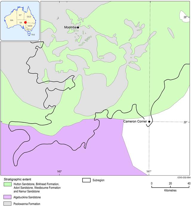
The stratigraphy of the Eromanga Basin is discussed in this section, and shown in Figure 10; this version is based on information for the southern Cooper Basin, and information from the external conceptual modelling of causal pathways workshop. Figure 12 shows the spatial extents of the lower Eromanga Basin sequences in the southern Cooper Basin.
As the Westbourne Formation thins and wedges out, the Adori, Hooray and Namur sandstones become collectively the Namur Sandstone. The overlying Murta Formation defines the extent of the Namur Sandstone.
The Birkhead Formation has a slightly greater westward extent than the Westbourne Formation and thus separates the Namur Sandstone from the underlying Hutton Sandstone. The Algebuckina Sandstone refers to the undifferentiated sandstone under the Cadna-owie Formation, where the Birkhead Formation wedges out.
On the south-east side of the Central Eromanga Depocentre where older units are absent, the Hooray Sandstone has broad extent out to the boundary of the Eromanga Basin.
Figure 12 Extent of Eromanga Basin units below the Cadna-owie Formation
Data: Geoscience Australia (Dataset 1, Dataset 12)
The Cadna-owie Formation is a marginal marine unit with a much broader extent; it always overlies the Algebuckina Sandstone. The Trinity Well Sandstone Member of the Cadna-owie Formation can be considered as a western facies equivalent to the Wyandra Sandstone Member, which is present in Queensland.
Within the overlying Rolling Downs Group, the nomenclatural changes are primarily determined by the limit of the south-western extent of the Toolebuc Formation. Beyond the Toolebuc Formation extent, the underlying upper part of the Wallumbilla Formation and the overlying Allaru Mudstone can no longer be readily differentiated and are grouped as the Oodnadatta Formation. The Coorikiana Sandstone is a spatially extensive, coarsening-upward sandstone unit with minor siltstone interbeds (Sheard et al., 2012). It differentiates the Oodnadatta Formation from the underlying Bulldog Shale. The Rolling Downs Group extends across the entire southern Cooper Basin.
Lake Eyre Basin
The geology of the Lake Eyre Basin sedimentary rocks is described in companion product 1.1 for the Cooper subregion (Smith et al., 2015b). The geological Lake Eyre Basin is up to 400 m thick in the southern Cooper Basin, where it overlies the Weena Trough (Figure 13). In the southern Cooper Basin the Cenozoic Lake Eyre Basin sequence thickens westward across the Weena Trough region. At approximately 50 m thickness in Queensland, there is a progressive thickening to over 200 m above the Weena Trough, then with a slight thinning to the west. Northward there is a slight thickening in the Tenappera Trough but a distinct thinning on the adjoining Murteree Ridge.
The Lake Eyre Basin sequence unconformably overlies the Winton Formation of the Eromanga Basin. This Cenozoic sequence comprises the basal Paleocene-Eocene Eyre Formation which is disconformably overlain by the Miocene Namba Formation. A relatively thin layer of Quaternary sediment (mainly sand) covers the Namba Formation throughout the southern Cooper Basin. The thickness of the Quaternary sediment is rarely recorded but known to be as much as 60 m in parts of the southern Cooper Basin, although evidence from drilling in the Weena Trough region suggests here it is only about 5 m. However, the pervasive seif dune topography across the subregion almost approaches a comparable scale of relief (Figure 13).
Figure 13 Thickness of the geological Lake Eyre Basin in the southern Cooper Basin
Data: Bioregional Assessment Programme (Dataset 4)
2.3.2.2.3 Groundwater flow directions, groundwater recharge and discharge
Lake Eyre Basin, regional watertable and surface drainage interactions
The regional watertable of the Great Artesian Basin (Kellett et al., 2012) is hosted in the Namba Formation and Quaternary sediments across the Weena Trough region. The watertable is broad and of low gradient across the southern Cooper Basin (Figure 14).
The watertable over the Weena Trough infers regional flow south-westwards towards Lake Blanche and adjacent salt lakes extending from Lake Frome through to lakes Callabonna, Blanche and Gregory. These are ephemeral salt lakes that precipitate halite from groundwater brine (Kellett et al., 2012). The southern side of this regional groundwater sink features a steep watertable gradient off the Flinders Ranges.
North of the Weena Trough the watertable gradients are more convoluted with a subtle groundwater mound centred over the Dunoon Ridge, and an adjoining subtle north–south depression centred over the Murteree High.
The watertable mapping and highly ephemeral nature of flow implies that Strzelecki Creek is not reliant on the watertable. It is likely that flow in Strzelecki Creek may contribute to recharging the watertable aquifer on the rare occasions water flows and is able to infiltrate the creek bed.
Figure 14 Subsurface depth to regional watertable in the southern Cooper Basin
Data: Geoscience Australia (Dataset 5), SA Department of State Development (Dataset 6)
Groundwater flow in the Eromanga Basin and Cooper Basin
The direction of groundwater flow in the Cadna-owie – Hooray Aquifer is inferred to be similar to that of the watertable, towards the series of salt lakes between Lake Frome and Lake Gregory (Keppel et al., 2016; Ransley et al., 2015). Keppel et al. (2016) identified that groundwater head data used previously to constrain the flow directions in the Cadna-owie – Hooray Aquifer (J-K aquifer) in the southern Cooper Basin were likely from bores which were screened in other hydrostratigraphic units. Subsequently, the potentiometric surface of the Cadna-owie – Hooray Aquifer was reinterpretated as part of the Lake Eyre Basin Springs Assessment (LEBSA). The revised flow in the Cadna-owie – Hooray Aquifer indicates a southward flow towards and beyond Lake Frome, and this flow direction is generally interpreted for the other Eromanga Basin units. Flow is also inferred to occur from the northern end of the Flinders Ranges (crystalline basement) north towards Lake Blanche, this flow path terminates at Lake Blanche, represented by a low in the contours on the south-western margin of the lake (Figure 15). A general south-westerly flow direction is shown by potentiometric surfaces presented by Dubsky and McPhail (2001) for the Cooper Basin hydrostratigraphic units; however, the data used to develop the potentiometric surfaces did not extend south of the Tinga Tingana Ridge.
Source: Figure 2-6 from Keppel et al (2016)
2.3.2.2.4 Hydrogeological connectivity
The issue of hydrogeological connectivity of basement with the Cooper Basin sequence has been discussed briefly in Section 2.3.2.2.1.
Cooper Basin – Eromanga Basin connectivity
A large area of Patchawarra Formation lies in contact with the basal unconformity of the Eromanga Basin west of the Tinga Tingana Ridge. This region of Patchawarra Formation extends across the Weena Trough, and most of the Milpera Depression. Eastwards and northwards from this region of Patchawarra Formation, progressively younger Cooper Basin formations lie at the basal Eromanga unconformity (Figure 8 and Figure 9).
The extents of Jurassic units at the basal unconformity to the Eromanga Basin over the southern Cooper Basin comprise the Hutton Sandstone, Algebuckina Sandstone and Poolawanna Sandstone. Downgradient of the Southern Cooper Basin Gas Project (the only proposed coal resource development in the subregion, see Section 2.3.4) and towards the lakes, the Patchawarra Formation may be considered as a leaky aquitard or partial aquifer, and to be in direct contact with aquifers or partial aquifers of the basal Eromanga Basin (Figure 16). The Hutton Sandstone is 40 to 60 m thick over the southern Cooper Basin and thickens northwards, along with the Algebuckina Sandstone (>150 m).
Data: Geoscience Australia (Dataset 7, Dataset 8)
Only in the northern sector of the southern Cooper Basin is the Poolowanna Formation aquitard present at the basal unconformity, but with many erosional windows and embayments enabling contact of the Hutton Sandstone with the Cooper Basin. This lies outside the area of the Southern Cooper Basin Gas Project.
Connection between Eromanga Basin hydrostratigraphy
Due to stratigraphic thinning of units towards the margins of the Eromanga Basin, the sequence of units from the base of the Eromanga Basin up to and including the Cadna-Owie Formation is generally grouped and referred to as the J-K aquifer. Hydraulic connection of the Hutton Sandstone with the Namur Sandstone (Cadna-owie – Hooray Aquifer) appears possible only through the window in the Birkhead Formation, that is, where this part of the sequence is identified as the Algebuckina Sandstone, at the southern end of the Tinga Tingana Ridge (Figure 12).
The total thickness of the Eromanga Basin across the southern Cooper subregion exceeds 1000 m, increasing to more than 1500 m thickness in the Tenappera Trough. The Rolling Downs Group (considered a tight aquitard and comprising the combined Wallumbilla Formation, Toolebuc Formation, Allaru Mudstone, Bulldog Shale and Oodnadatta Formation) comprises between 32% and 39% of the total Eromanga Basin sequence in the Weena Trough region, and is always greater than 370 m thick. The Coorikiana Sandstone appears to be an important potential source for several bores and springs on the floor of Lake Blanche, according to recent work undertaken for LEBSA (Keppel et al., 2016). However, the Coorikiana Sandstone is underlain by thick, very low permeability Bulldog Shale (a regional aquitard) and overlain by thick, very low permeability Oodnadatta Formation.
Polygonal faulting is pervasive within the entire Rolling Downs Group, as evident in seismic interpretation of the Lake Hope area (Watterson et al., 2000), and exposed in the floor of Lake Gregory (Ransley et al., 2015). This style of intraformational faulting may introduce a potential for inter-aquifer connectivity across an aquitard (Ransley et al., 2015, p. 38). Where polygonal faulting is mapped within the Great Artesian Basin, head differences between the Rolling Downs Group and overlying and underlying aquifers show that the aquitard is not compromised by these structural features (Smerdon et al., 2012). In the southern Cooper subregion the considerable thickness of the aquitard (Figure 17) would argue against any significant vertical transmissivity. In addition, there is no substantive evidence available for the role of intra-formational faulting in vertical transmissivity in the Rolling Downs Group for the southern Cooper Basin.
In this region of the Eromanga Basin there is a thick weathering overprint on the Winton Formation, an alteration zone of about 100 m thickness (see Map 18 in Ransley et al., 2015). In this zone, the rocks are weathered to clays, thus further reducing the effective hydraulic conductivity of the Winton Formation.
Collectively, the very thick Rolling Downs Group in the southern Cooper Basin and an upper aquifer with a thick upper regional seal are considered to provide a very low permeability barrier in the Rolling Downs Group, significantly diminishing the potential for vertical hydraulic transmissivity.
Figure 17 Thickness of the Rolling Downs Group aquitard over the southern Cooper Basin
Data: Geoscience Australia (Dataset 9)
Eromanga Basin – Lake Eyre Basin connectivity
The Eyre Formation is a relatively consistent aquifer, in that it has a fairly uniform lithological character and is relatively undeformed. It is characterised by a silcrete overprint at the top of the formation (Alley, 1998; Callen et al., 1995). This silcrete is a potentially impermeable barrier to upward groundwater migration. The thickness of this Eyre Formation aquifer ranges from about 12 to 60 m over the Weena Trough. However, there are greater thickness variations over the Tenappera Trough (thicker) and Murteree High (thinner) areas.
The overlying Namba Formation is a regional aquitard comprising fine-grained lacustrine sediments, but with random channel sands forming localised linear aquifers. The Namba Formation is generally thicker than the Eyre Formation, and the greatest difference in thickness is across the Weena Trough where the Namba aquitard exceeds threefold the Eyre Formation thickness (e.g. Weena-1: 158.5 m Namba Formation over 44.5 m Eyre Formation).
2.3.2.2.5 Lake Blanche springs
The watertable surface in the southern Cooper Basin indicates low-gradient groundwater flow only as far as the nearby regional sink – the groundwater discharge zone along an arcuate band extending from Lake Frome through lakes Callabonna, Blanche and Gregory (Figure 18).
Previous work identified that the springs on the floor of Lake Blanche were sourced from an Eromanga Basin aquifer, but not enough data was available to assign a particular source aquifer with confidence (Hydrogeologic Pty Ltd, 2014). The Hutton Sandstone (basal Eromanga Basin aquifer) has been identified as having a direct connection with the Patchawarra Formation in the Weena Trough, as a result of revised stratigraphy presented in Section 2.3.2.2.2.
As part of the broader Bioregional Assessment Programme, the SA Government was commissioned to undertake a number of projects, including the LEBSA. Hydrogeochemical information and springs field surveys carried out on the Lake Blanche springs by the South Australian Department of Environment, Water and Natural Resources (DEWNR) are of specific interest for the Cooper subregion. From this work, conceptual models, knowledge base tables and spring typologies were developed and reported by Keppel et al. (2016). These conceptual models recognise that hydrogeological changes from groundwater extraction and contamination influence the flow rate, pH, conductivity and dissolved oxygen content of discharge waters. These drivers, in turn, influence the spring vegetation communities, endemic and relict flora, and endemic fauna (Keppel et al., 2016; SA Department of Environment Water and Natural Resources, 2015b).
The spring typology of the Lake Blanche Spring complex is described as predominantly flat depressions, or salt lake (non-brine density type) springs (Gotch et al., 2016; Keppel et al., 2016). The springs are sourced by water from the Coorikiana Sandstone and the Cenozoic aquifers, as shown by distinct hydrogeochemical characteristics, including chlorine-36 isotopic analyses, stable isotopes of hydrogen and oxygen and strontium isotopes. The water reaches the surface via a fracture or fault pathway, shown by reconnaissance electrical geophysical surveys (Keppel et al., 2016; SA Department of Environment Water and Natural Resources, 2015a). Some water input may be contributed from the watertable aquifer as well. Springs may occur as isolated sand mounds or fringing seeps (Keppel et al., 2016; SA Department of Environment Water and Natural Resources, 2015b).
