- Home
- Assessments
- Bioregional Assessment Program
- Cooper subregion
- 1.1 Context statement for the Cooper subregion
Executive summary

The context statement brings together what was known about the geography, geology, hydrology and ecology of the Cooper subregion as at July 2015.
Geography
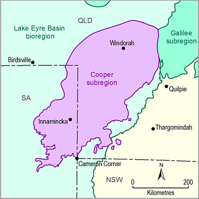
The Cooper subregion spans an area of about 130,000 square kilometres and is located entirely within the Lake Eyre drainage catchment. About two-thirds of the subregion is located in south-west Queensland and the remainder in north-east South Australia and far north-west New South Wales.
The subregion is sparsely populated with 1032 residents. The mining sector is the largest employer in the subregion.
The subregion covers the Birria, Wangkumara, Yandruwandha, Yawarawarka and Karuwali Indigenous tribal or language groups and there are 14 Indigenous Land Use Agreements in place. Pastoral grazing represents more than 80% of land use in the subregion with much of the remaining land area dedicated to nature conservation.
Geology
The Cooper subregion incorporates the Cooper–Eromanga Basin hydrocarbon system. It is Australia’s premier onshore oil and gas producing area and, as such, its geology is well understood. Prospecting in the Cooper Basin is high, with shale gas and deep coal seam gas under active exploration. The Cooper Basin contains approximately 190 gas fields with 115 oil fields in production.
Coal resources within the Cooper and Eromanga basins occur at depths of more than one kilometre and, based on existing technology, are too deep to mine. Parts of these basins are, however, prospective for coal seam gas.
Surface water and groundwater
The Cadna-owie Formation and Algebuckina Sandstone are the main aquifers in the Cooper subregion and represent both artesian and non-artesian systems. Water quality in the Cooper Basin aquifers is generally brackish to saline, while groundwater in the aquifers of the Eromanga Basin and the Lake Eyre Basin are generally suitable for stock and domestic use.
Much of the Cooper subregion is part of the Cooper Creek–Bulloo river basin. Cooper Creek and the Thomson, Barcoo and Bulloo rivers are the major streams in this basin. The Cooper Creek flows some 1500 kilometres south-west to Kati Thanda—Lake Eyre and during periods of high flow its floodplain can exceed 15,300 square kilometres with a width exceeding 60 kilometres.
Rainfall ranges from 200 to 600 millimetres per year.
Ecology
The Cooper subregion is ecologically diverse. It contains 27 major plant subgroups; a further eight wetlands are listed as nationally important.
At more than two million hectares, the Coongie Lakes reserve and surrounds, located in the south-west of the subregion, constitute Australia’s largest area designated as a wetland of international importance.
In the Cooper subregion, 18 species are listed under Commonwealth legislation, a further 45 species are listed under Queensland legislation, 48 species under New South Wales legislation and 82 species under South Australian legislation.

