Hazards associated with CSG operations considered to be in scope for BA purposes were grouped for the Cooper subregion according to their hydrological pathway to impact. These causal pathway groups represent models linking an activity with a potential impact on the groundwater or surface water. The identified causal pathways are shown in Table 9, and discussed in the following sections. They are a subset of the causal pathways described in companion submethodology M05 for developing a conceptual model of causal pathways (Henderson et al., 2015). The causal pathways were discussed and refined during the external conceptual models of causal pathways workshop held in Adelaide on 11 and 12 November 2015.
Table 9 Causal pathway groups identified for the coal resource development pathway for the Cooper subregion
CSG = coal seam gas
Only causal pathways identified for the coal resource development pathway (CRDP) are included as there are no coal resource developments in the baseline for the Cooper subregion
Proposed CSG development in the Cooper subregion targets the Patchawarra Formation at depths of 1900 to 2100 m. The main Eromanga Basin aquifers in the southern Cooper subregion are the Winton and Mackunda formations, the Coorikiana Sandstone (collectively referred to as the K-aquifer), the Cadna-owie – Hooray Aquifer and equivalents (including the Algebuckina Sandstone) and the Hutton Sandstone (collectively referred to as the J-K aquifer). The Patchawarra Formation is considered as a partial aquifer or leaky aquitard in the subregion, and is in direct connection with the Hutton Sandstone and Algebuckina Sandstone. These aquifers are more porous and permeable (Kellet et al., 2012), and hence have greater capacity to store and transmit groundwater, than the Patchawarra Formation. The main aquitards in the southern Cooper subregion are the Bulldog Shale and Oodnadatta Formation and the Allaru Mudstone, Toolebuc Formation and Wallumbilla Formation of the Rolling Downs Group. There is a potential aquitard section in the intra-Patchawarra shale unit identified in the recent stratigraphic reinterpretation (Morton, in review); however, the hydraulic character of this unit is undefined at this stage. The target coal seams in the Patchawarra Formation occur below this intra-Patchawarra unit. The lithology of the Patchawarra Formation in the Weena Trough (Section 2.3.2 and Morton, in review), and hydraulic parameters of the Patchawarra Formation in the Cooper Basin more broadly (Dubsky and Macphail, 2001), are such that it represents a leaky aquitard or aquitard hydrostratigraphy. The geological character of the rocks, and their associated hydraulic parameters, in conjunction with the separation of the CSG target within the Patchawarra Formation limits the amount of hydraulic connection with the overlying hydrostratigraphic units.
The geology and hydrogeology of the southern Cooper subregion are discussed in Section 2.3.2, and can be represented conceptually in terms of potential and demonstrated linkages as shown in Figure 29. This conceptualisation forms the basis for narrative relating to the groundwater causal pathways in Table 9. The hydrostratigraphic framework incorporates the revised stratigraphy for the Weena Trough, which was provided and discussed at the external conceptual models of causal pathways workshop, and is adopted as the working framework for the southern Cooper subregion.
Known hydrological links are established based on geological contact between units, or demonstrated hydrogeological linkages. For example, the Coorikiana Sandstone aquifer hydrological link with the Lake Blanche springs is demonstrated by hydrogeochemical data provided by the Lake Eyre Basin Springs Assessment (LEBSA) Lake Blanche springs hydrogeology and springs conceptualisation update (Keppel et al., 2016), and discussions at the external conceptual models of causal pathways workshop. The links between the Cenozoic Lake Eyre Basin and Quaternary hydrogeological units with Lake Blanche are demonstrated by the lake representing the discharge area for the watertable, and these units hosting the watertable. Similarly, local discharge from perched watertables, or recharge to such, is considered to occur around the stream network (Strzelecki Creek). Geological cross-sections in Figure 8 and Figure 9 in Section 2.3.2 illustrate the nature of the propagation pathway from proposed CSG operations activities to the surface. It is important to consider the potential groundwater causal pathways both vertically and laterally.
LEB refers to the geological Lake Eyre Basin, consisting broadly of the Eyre and Namba formations. SW-GW refers to surface water – groundwater. J-K and K aquifer refer to alternative aquifer names used in the region.
2.3.5.3.1 Subsurface depressurisation and dewatering
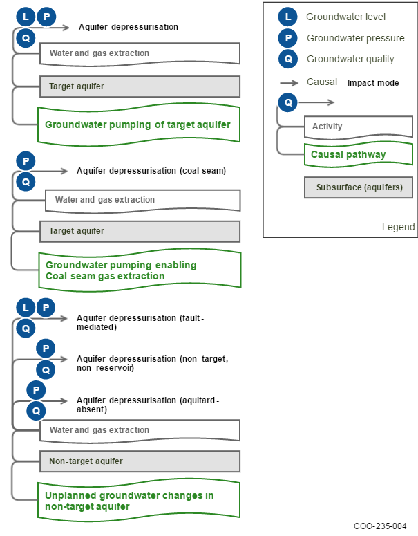
This group of causal pathways arises when CSG operations intentionally dewater and depressurise subsurface hydrostratigraphic units (such as coal seams and aquifers) to permit coal resource extraction. Pumping groundwater to enable coal resource extraction modifies pre-existing groundwater gradients, for example, changes groundwater levels, pressures or chemistry of aquifers. A number of activities may affect the pressure gradients that control the direction and rate of groundwater transmission within different hydrostratigraphic layers, for example: depressurising a water-saturated target coal seam to induce desorption and subsequent extraction of CSG (‘Groundwater pumping enabling coal seam gas extraction’ causal pathway). Groundwater level or pressure is most commonly altered as a direct result of depressurisation, but other gradients can also be changed via this process, such as temperature, density or chemical composition (water quality). This causal pathway group also includes conventional groundwater extraction from aquifers (‘Groundwater pumping of target aquifer’ causal pathway), which may be undertaken to supply water resources to support development and production activities associated with CSG operations. However, the scale of these effects is typically much less than those associated with CSG extraction. The ‘Unplanned groundwater changes in non-target aquifers’ causal pathway is also included in this group. This pathway includes impacts outside the target aquifer as a result of direct connections with other hydrostratigraphic units allowing propagation. This can occur as a result of geological structures, or where the target unit is in direct stratigraphic connection with another hydrostratigraphic unit.
Groundwater pumping enabling coal seam gas extraction causal pathway
Depressurisation is necessary to facilitate desorption of gas from the target coal seams in CSG production. This is achieved by pumping formation water out of the target zone. This depressurisation may propagate into adjacent, connected hydrostratigraphic units, and thus to the watertable. Depressurisation reduces the potentiometric head (pressure) in the target CSG formation and connected hydrostratigraphic units. This pressure reduction usually extends radially from the pumping zone, producing a drawdown cone. Impacts include changes in groundwater flow, pressure and level. The causal pathway for propagation of depressurisation is shown in Figure 30. Landscape classes identified as being groundwater dependent may be susceptible to this causal pathway.
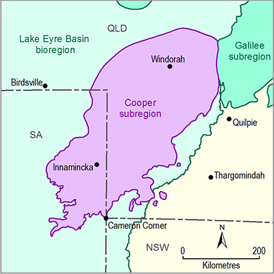
The areal extent of depressurisation in the target formation in the Southern Cooper Basin Gas Project has been analytically modelled for initial production testing activities (Hydrogeologic Pty Ltd, 2014) according to the requirements of the Far North Water Allocation Plan (SA Arid Lands NRM Board, 2009). The Far North Water Allocation Plan (FNWAP) specifies that drawdown must not exceed 0.5 m at 5 km from an identified spring, 1 m at the boundary of the Southwest Springs Zone, and 10% of the head at a state border (10 m in this case). This analytical model identified that the maximum expected drawdown in the Patchawarra Formation would be 0.5 m at a distance of 40 km from the centre of pumping. The Hydrogeologic Pty Ltd (2014) analytical model used a conservative steady-state approach, including overestimation of hydraulic parameters and overestimation of water production rates. The water production rates were estimated at 240 kL/day per well, for ten wells (Hydrogeologic Pty Ltd, 2014), whereas actual pumping rates recorded during production testing are between 30 and 85 kL/day per well, for four wells. Hydraulic parameters from the Cadna-owie – Hooray Aquifer were assumed to apply to the production zone, as opposed to lower values from the actual target formations (Hydrogeologic Pty Ltd, 2014). A similar approach was undertaken for this Assessment (Bioregional Assessment Programme, Dataset 3), using a pumping rate of 3.375 ML/day over 15 years centred at the Klebb wells, and applying the same hydraulic properties as the Hydrogeologic Pty Ltd (2014) estimation. The resulting drawdown extent and magnitude is shown in Figure 31. Given the depth of the target production zone, and the stratigraphy presented in preceding sections, it is unlikely that the drawdown impact would extend beyond the Cadna-owie and equivalent hydrostratigraphic units, and that any propagated drawdown would be significantly less than that presented for the Patchawarra Formation.
Data: Bioregional Assessment Programme (Dataset 2, Dataset 3, Dataset 7), Queensland Herbarium (Dataset 4), SA Department of Land Water and Biodiversity Conservation Knowledge and Information Division (Dataset 5) and SA Department of State Development (Dataset 6)
The extent of the coal resource developments in CRDP is the union of the extents for baseline and additional coal resource development.
Southern Cooper Basin Gas Project location © Strike Energy Limited
Groundwater pumping of target aquifer causal pathway
Water is required for drilling, hydraulic fracturing, dust suppression, accommodation and other support activities. As discussed in JBS&G Australia Pty Ltd and Strike Energy Limited (2014) the most likely source of water for operations is groundwater. This may be extracted from existing bores, as well as from specifically constructed bores. Other sources may include water reuse, water being trucked in from off-site, or opportunistic harvesting of surface water. Information provided at the external workshop for conceptual models of causal pathways indicated that produced water from CSG wells is the most likely source of water for drilling and fracturing during operations. The potential pathways for impact for groundwater extraction are similar to the ‘Depressurisation for gas extraction’ causal pathway (Figure 30) and the ‘Well integrity’ causal pathway (Figure 32). Landscape classes identified as being groundwater dependent may be susceptible to this causal pathway.
Groundwater extraction is most likely to be from the Eromanga Basin and Cenozoic Lake Eyre Basin aquifers, as well as Cooper Basin formation water from converted petroleum bores, or from co-produced water. These aquifers are currently subject to extraction by other users in the southern part of the Cooper subregion, either for stock purposes, or for industry and exploration activity. Additional extraction from these resources will be managed according to relevant state-based regulation, which will consider potential impacts on these other users.
Unplanned groundwater changes in non-target aquifers causal pathway
A significant body of work has been developed investigating the hydrogeological characteristics of geological structures, in particular faults. Fault zones may act as hydraulic conduits, connecting shallow and deep geological environments, but simultaneously the fault cores of many faults often form effective barriers to flow (e.g. Bense et al., 2013; Bense and Person, 2006; Bredehoeft, 1997; Caine et al., 1996). More broadly, geological structures may act as barriers or preferential pathways to fluid flow. Within and across lithological units, preferential flow paths can exist through fractures and faults (Commonwealth of Australia, 2014a). They may:
- compartmentalise the hydrogeological system, effectively isolating areas
- connect different hydrostratigraphic units, effectively connecting distinct aquifers or juxtaposing aquifers against aquitards
- facilitate linkage with the surface water system, as is the case for some springs
- have no effect on the flow of groundwater.
Faults may also be intraformational (i.e. not extending beyond one geological unit into another). This is discussed with reference to the Cooper subregion in Section 2.3.2.2.4.
Landscape classes identified as being groundwater dependent may be susceptible to this causal pathway.
The role of geological structures in this causal pathway is related to the possibility for structures to connect parts of the groundwater system with other parts, or with surface water. To that end, they may propagate impacts. In the southern Cooper subregion, the geometry and geological history of the Weena Trough may be partly influenced by faulting. This is uncertain, due to the lack of data that can be used to interpret geological structures in the region. It is possible that the glacial valley that became the Weena Trough may have developed by exploiting a pre-existing (fault-controlled) structural weakness in basement (Morton, in review). In addition, the presence of intraformational faulting in the aquitard units of the Rolling Downs Group in the Cooper subregion provides a potential pathway for propagation of impact. While evidence for intraformational faulting in the Weena Trough has not been found to date, discussion of the role of intraformational faulting acting as potential inter-aquifer connections is unlikely, as discussed in Section 2.3.2.2.4.
2.3.5.3.2 Subsurface physical flow paths
causal pathways involves physical modification of the rock mass or geological architecture by creating new physical paths that water may potentially infiltrate and flow along. Just because a new physical path is created does not necessarily mean that water will start flowing along it in preference to how it flowed before – it will still follow the path of least resistance, and be governed by pressure gradients. This causal pathway group can, however, potentially lead to direct hydraulic connection between the target strata and other hydrostratigraphic units (such as regional aquifers), by creating new zones of deformation in the rock mass. This may occur when the integrity of wells drilled for groundwater or gas extraction is compromised, or may occur due to hydraulic fracturing of coal seams.
Failure of well integrity causal pathway
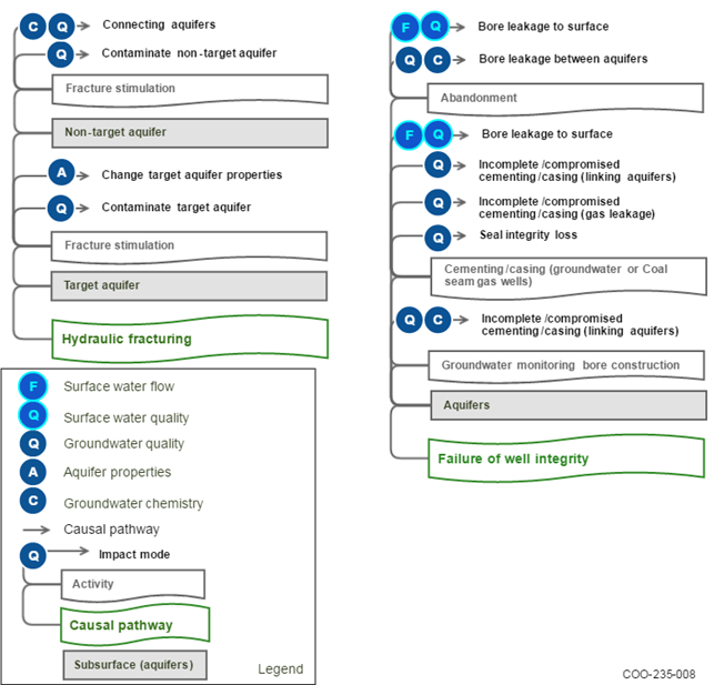
Well construction may lead to enhanced connection between layers. The causal pathway for this hazard arises from drilling a well for CSG operations or drilling a water bore for groundwater supply (Figure 32). A well that is not completely sealed with the surrounding material may provide a direct conduit for water to any other unit the well or bore penetrates, or to the land surface. This may be as a result of well construction, degradation of the well sealing materials over time, or changes in the aquifer material or structure over time. Well construction may increase local connectivity (Commonwealth of Australia, 2014a; Stuckey and Mulvey, 2013), and allow the mixing of waters from previously disconnected units of different quality and chemical properties, or of any fluid introduced down the well with groundwater. More information on well integrity and well failure in the Australian context can be found in Commonwealth of Australia (2014b). Landscape classes identified as being groundwater dependent may be susceptible to this causal pathway.
Data were provided at the external workshop for conceptual models of causal pathways (SA Department of State Development, 2015, pers. comm.) for petroleum well failures in the Cooper Basin in SA. This shows that there have been four instances of petroleum well failure observed out of 2288 petroleum wells drilled. ‘Failure’ is an event in a well that has caused either:
- fluid crossflow between two formations or
- fluid flow from a formation to the surface (not including wellhead leaks).
These failures were in wells (drilled into the Patchawarra and Nappamerri troughs):
- Big Lake-2 (2500 m total depth; blowout), drilled in 1963
- Della-1 (2179 m total depth; blowout), drilled in 1970
- Tirrawarra-3 (2019 m total depth; low rate flow to surface), drilled in 1971
- Della-20 (3018 m total depth; crossflow between formations behind casing), drilled in 2000.
In addition, there has also been one failure (blowout) in the Habanero-3 geothermal well (4221 m total depth) drilled in 2004, out of the seven geothermal wells in the South Australian Cooper Basin.
Information relating to water bores indicated that the average time before casing failure in PVC bores was 25 years for SA (SA DEWNR, 2015, pers. comm.).
Hydraulic fracturing causal pathway
Hydraulic fracturing is required to assist with depressurisation of the target coal seam, which in turn facilitates desorption. Hydraulic fracturing is a highly targeted and controlled process. Co-produced water is recovered and directed to storage ponds, and flowback fluid is pumped and recovered according to approved site management practices. The hydraulic fracturing causal pathway will result in changes to groundwater pressures and flow in the target formation, and could result in possible contamination and depressurisation of adjacent, connected units as a result of induced connectivity (Figure 32).
The extent of hydraulic fracturing and its associated effects is highly dependent on the nature of the resource being extracted. It varies with the density and number of wells, the rate, duration, staging and intensity of fracturing, the orientation and strength of the geological stress field, the geological complexity of the target seam and adjacent rock mass, and the hydraulic properties of the target seam and adjacent rock mass. Landscape classes identified as being groundwater dependent may be susceptible to this causal pathway.
In the CRDP for the Cooper subregion, hydraulic fracturing will be necessary to liberate gas from the Patchawarra Formation coals. Strike Energy has undertaken hydraulic fracturing as part of their production testing activities at all four wells (JBS&G Australia Pty Ltd and Strike Energy Limited, 2014; Strike Energy Limited, 2015). Data obtained from hydraulic fracturing of wells Klebb-1 and Le Chiffre-1 show that the fractures did not propagate beyond the target zone (JBS&G Australia Pty Ltd and Strike Energy Limited, 2014). Information provided at the external conceptual modelling for causal pathways workshop indicated that subsequent hydraulic fracturing stages did not extend beyond the target zones, and that this is supported by data from tilt-meter and pressure monitoring. Fracturing operations in the Weena Trough require pumping of the hydraulic fracturing fluids at approximately 27,500 kPa, which is much lower than fracturing in deeper parts of the Cooper Basin in the order of 69,000 to 103,000 kPa, to initiate fracture development. In addition, the soft nature of the coal and contrasting strong adjacent rock mass act to contain fracture propagation to the coal seams. The available evidence from initial CSG well testing by Strike Energy Limited has shown that hydraulic fractures are contained within target coal seams and do not propagate beyond into adjacent hydrostratigraphic units. Thus, at this stage, there is no evidence that hydraulic fracturing activity in Cooper CSG fields will create new subsurface flow paths. In addition, any fluids injected during hydraulic fracturing operations will be contained within the target unit within the Patchawarra Formation. The Patchawarra Formation is not utilised as a groundwater source in the Cooper subregion.
2.3.5.3.3 Operational water management
Water produced from CSG extraction wells is recovered and stored at the surface in lined and bunded ponds. There is no provision for release to surface water or reinjection in the CRDP for the Cooper subregion. Storage ponds will be designed and constructed according to relevant standards and regulations. The potential causal pathway for co-produced water is via containment failure, which is illustrated by the ‘Discharging extracted water to surface water’ causal pathway. Another pathway is for impacts to groundwater quality via seepage from the storage ponds.
The ‘Sourcing water for on-site operations’ causal pathway is covered by the ‘Groundwater pumping of target aquifer’ causal pathway, as the Southern Cooper Basin Gas Project will be sourcing all its water for operational requirements from groundwater sources (JBS&G Australia and Strike Energy Limited, 2014). The ‘Reinjecting co-produced water into aquifer’ causal pathway is not considered in the Cooper subregion, as it is not part of the proposed operational water management regime.
The discharge of extracted water into surface water systems in the Cooper subregion can only occur via unregulated or forced release of water from containment. This may lead to changes in the surface water flow regime, resulting from changes to the distribution of surface materials redirecting surface water flow. Another change to the surface water regime is surface water quality change as a result of a release of contaminants. These events are ‘one-off’, or discrete, and can be thought of as similar to a high-flow or flood event. The impact will vary with the configuration of containment facilities, configuration and flow character of the surface water network and the magnitude of the release.
Within the southern Cooper subregion, the surface water feature that could potentially be affected by a loss of containment is the ephemeral, low-gradient Strzelecki Creek. Downstream effects could propagate to Lake Blanche. Strzelecki Creek experiences large variations in discharge and flow duration, from periods of no flow to flooding. Information provided in JBS&G and Strike Energy Limited (2014), and discussion at the external of causal pathways workshop identified that water containment facilities are currently constructed to specified standards, including lining and bunding. Site-specific high resolution digital elevation models discussed at the external conceptual models of causal pathways workshop show that water containment structures are situated in locations that are disconnected from Strzelecki Creek (Strike Energy Limited, 2015, pers comm).
2.3.5.3.4 Surface water drainage
This group of causal pathways involves the physical disruption and disturbance of surface topography and near-surface materials (vegetation, topsoil, weathered rock). Such landscape changes can alter parameters such as the direction, volume and quality of surface flow over the landscape within the mine lease, and may reduce runoff to the stream network. Surface disturbance can also lead to enhanced soil erosion rates, which can then affect surface water quality, for example, through increased stream sediment loads. This group of causal pathways typically starts with activities associated with development of the CSG well network and related infrastructure. It can include activities such as diverting water around operations areas with drains or walls, realigning part of a stream network to permit mining to occur, or clearing vegetation and soil to construct a drilling pad. For the Cooper subregion, the ‘Intercepting surface water runoff’ causal pathway is considered to be covered by site-based management practices, while the ‘Altering surface water system’ causal pathway is considered to be a potential causal pathway and warrants further discussion. Landscape classes associated with floodplains, streams, lakes and springs may be susceptible to this causal pathway group.
Altering surface water system causal pathway
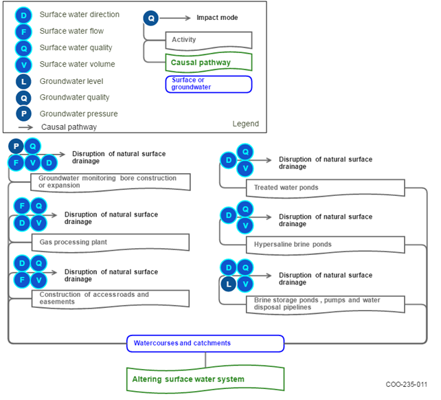
Altering the surface water system may lead to a loss, or redirection, of runoff that can have long-term cumulative effects on downstream watercourses. The physical infrastructure of CSG operations, including land clearing, land levelling, the construction of hard packed areas such as roads and tracks, pipelines and plant for collection and transport of gas can disrupt natural drainage systems by redirecting and concentrating flows. Water flow and landscape topography co-evolve in natural systems such that the areas of most concentrated flow are the most resistant to erosion. Changes in flow regime and catastrophic events can alter flows and pathways either temporarily before returning to the previous state, or semi-permanently until the next event. In the same way, human-made structures and earth works associated with CSG exploration and production may divert and concentrate surface flow. This may lead to erosion of the land surface, stream banks or streambeds, and alter water quality in streams if new material is mobilised and washed into them. Given the low-topographic gradient across the southern Cooper subregion, minor changes that could result from infrastructure development could have an impact on surface water flow. This is reflected in the hazard scoring, with a higher severity score given for drainage disruption modes relative to other subregions (Bioregional Assessment Programme, Dataset 1). The impact of any disruption to surface water drainage will vary with the configuration of the surface water network and the flow character of the receiving surface water system. The conceptual model of this causal pathway is shown in Figure 34.
Within the southern Cooper subregion, the surface water feature that could potentially be disrupted due to infrastructure for CSG operations is the ephemeral, low-gradient Strzelecki Creek. Downstream effects could propagate to Lake Blanche. The Southern Cooper Basin Gas Project is located adjacent to existing roads and gas pipelines, so the requirement for major infrastructure development will be small. However, this will depend upon the final layout of the CSG operations including well spacing and number of wells, and location and type of support infrastructure such as accommodation, roads, gas flowlines, water management infrastructure and processing infrastructure.


