The zone of potential hydrological change (Figure 12) identifies the area potentially subject to hydrological changes due to additional coal resource development. It is derived from the union of the groundwater zone of potential hydrological change (Figure 10) and the surface water zone of potential hydrological change (Figure 11). The Namoi zone of potential hydrological change covers an area of 7014 km2 (19.7% of assessment extent) in which 5521 km of stream length is potentially impacted (based on Geofabric stream network (Bureau of Meteorology, Dataset 3)). Four regions (Table 5) are defined for reporting purposes to provide greater detail around key coal resource development areas within the subregion.
The zone of potential hydrological change is the first filter applied to landscape classes and water-dependent assets in the Namoi subregion as part of an initial selection process for the impact and risk analysis. Landscape classes and assets that are completely outside the zone are very unlikely (less than 5% chance) to be impacted due to additional coal resource development and do not have qualitative landscape models or receptor impact models. Conversely, some landscape classes that intersect the zone have qualitative models and/or receptor impact models, which are used to assess the potential impact of the modelled hydrological changes on the ecosystems. Details of the qualitative models and receptor impact models are provided in companion product 2.7 for the Namoi subregion (Ickowicz et al., 2018). Results of the receptor impact modelling are presented in Section 3.4.
3.3.2.1 Mine pit exclusion zone
Figure 12 also shows the mine pit exclusion zone defined for the Namoi subregion. It is based on open-cut mine footprints under the CRDP within the zone of potential hydrological change. The mine pit exclusion zone identifies areas within the zone of potential hydrological change that are within, or in close proximity to, open-cut mine pits, and where:
- modelled drawdowns are highly uncertain due to the very steep hydraulic gradients at the mine pit interface
- changes in the drawdown are inevitable where the mine pit intersects the regional watertable and will extend to the pit floor
- other factors, such as physical removal of a wetland or creek, may have a larger impact on a landscape class than the predicted decrease in groundwater level
- impacts are predominantly site-scale, and addressed through existing development approval processes, and hence not the primary focus of BAs.
The modelled estimates of drawdown within the mine pits, while significant, are considered unreliable for use in the receptor impact modelling. The mine pit exclusion zone within the zone of potential hydrological change covers an area of 116 km2.
3.3.2.2 Reporting areas
The Assessment team identified four discrete areas within the zone of potential hydrological change for reporting purposes (Figure 12). Table 5 identifies the additional coal resource developments within each reporting area. In the Namoi river basin, the four areas are connected by the surface water zone of potential hydrological change, which means that results reported for the Lower Namoi include changes from the Mid Namoi, Pilliga and Pilliga Outwash, and Upper Namoi. These reporting areas do not coincide with any reporting areas used by the state agencies.
Table 5 Reporting areas and modelled additional coal resource developments
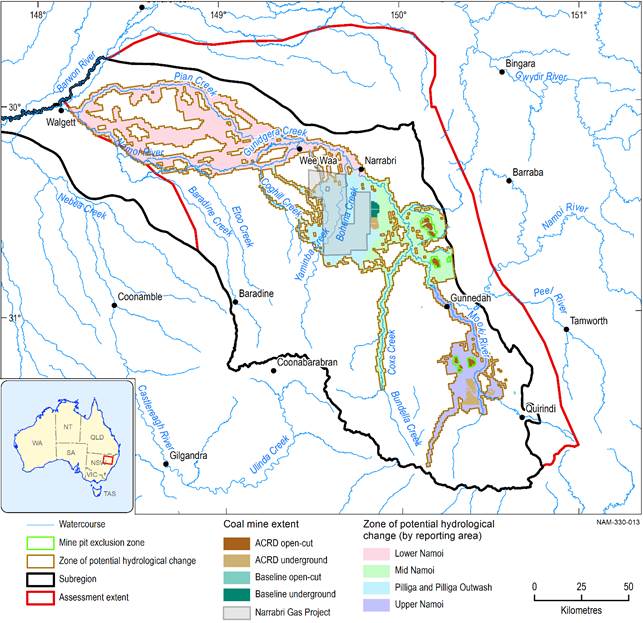
Figure 12 Zone of potential hydrological change
Data: Bioregional Assessment Programme (Dataset 3, Dataset 4, Dataset 5)
