In this section, potential impacts due to additional coal resource development on ecological, economic and sociocultural assets are assessed. The ecological assets are divided into three subgroups: ‘Surface water feature’, ‘Groundwater feature (subsurface)’ and ‘Vegetation’. The ‘Vegetation’ subgroup is further divided into two classes: ‘Groundwater-dependent ecosystem’ and ‘Habitat (potential species distribution)’ to improve clarity. Similarly, the economic assets are divided in two subgroups: ‘Groundwater management zone or area’ and ‘Surface water management zone or area’. The intersection of sociocultural assets with the zone of potential hydrological change is then described, and the potential for impact assessed.
Given the large number of assets involved in the assessment, it is not possible to assess the risk to each individual asset in this section. The analysis undertaken here focuses on potential impacts on assets in terms of the association or spatial intersection with landscape classes experiencing varying levels of hydrological change. As detailed in Section 3.4, potential impacts on relevant water-dependent landscape classes are defined using the hydrological response variables associated with the quantitative receptor impact modelling. This subset of landscape classes is termed ‘potentially impacted landscape classes’. The hydrological response variables are assigned to landscape classes based on these models and changes in these variables informs the assessment of where impacts to landscape classes are likely to occur. For assets that intersect any part of a potentially impacted landscape class, a more detailed assessment of the level of risk is presented. Thus, for any asset in the assessment extent (Bioregional Assessment Programme, 2017; Bioregional Assessment Programme, Dataset 1) the likely level of impact is based on its spatial extent overlapping:
- the zone of potential hydrological change
- a water-dependent landscape class (comprising all classes within ‘Floodplain or lowland riverine’, ‘Non-floodplain or upland riverine’, ‘Rainforest’ and ‘Springs’ landscape groups)
- a potentially impacted water-dependent landscape class. For those landscape classes with receptor impact modelling, changes in specific hydrological models can be mapped to a particular asset
- locations with relevant hydrological modelling and that surpass the ‘more at risk of hydrological changes’ threshold.
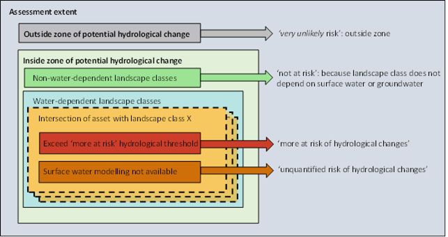
Figure 42 Overview of the different risk categories used to assess ecological assets
These distinctions are used to focus the discussion of assets into where impacts are most likely (Figure 42). An assessment of risk from changes in groundwater drawdown for assets that overlap the remaining water-dependent landscape classes (i.e. landscape classes that have qualitative modelling but no quantitative modelling) has also been carried out (Figure 42). Detailed potential impacts on individual assets can be visually explored on the BA Explorer, available at www.bioregionalassessments.gov.au/explorer/NAM/assets.
