In 2013–2014 coal production in the Sydney Basin bioregion came from four mines in the Southern Coalfield and four in the Western Coalfield. The geographic locations of the Coalfields are shown in Figure 3. Raw production figures are provided in Table 3.
Table 3 Coal production in Sydney Basin bioregion in 2013 to 2014 by mine
OC = open-cut; UG = underground
Source: NSW Department of Industry, Skills and Regional Development (2014, p. 53 and 67)
Approximately two-thirds of the coal produced in the Sydney Basin bioregion in 2013–2014 was from mines in the Southern Coalfield. Small portions of the Hunter and Newcastle coalfields sit within the north-eastern portion of the Sydney Basin bioregion. However, there are limited current coal workings in these areas. A description for the Hunter and Newcastle coalfields can be found in companion product 1.1 for the Hunter subregion (McVicar et al., 2016). The Western Coalfield (Figure 3) includes some mines (e.g. Ulan and Bylong), which are not part of the Sydney Basin bioregion as defined by the Bioregional Assessment (BA).
The Southern Coalfield is renowned for its premium quality, hard coking coals. They occur mainly in the Bulli Coal and are extracted from depths of over 400 m using underground methods and sold to both the domestic and international steel industry. Un-mined resources of prime coking coal are typically in the Bulli Coal and the Balgownie Coal Member under the Camden-Campbelltown-Picton region; however, this is a rapidly growing metropolitan area of Sydney, and subject to strategic release and other government policy, which limit opportunities for coal resource development (NSW Government Land & Property Information, 2015). In the Western Coalfield the Katoomba Coal Member and the Ulan, Lithgow and Lidsdale coals are of primary economic interest. Coal reserves for the various coalfields are given in Table 3, from NSW Trade and Investment (2014). The stratigraphic column in Figure 29 of companion product 1.1 for the Sydney Basin bioregion (Herron et al., 2018) shows the main coal-bearing geological units in the Western and Southern coalfields.
Section 1.2.1.1.1 and Section 1.2.1.1.2 discuss the stratigraphic nomenclature and classification of the main coal-bearing units of the Southern and Western coalfields, as well as some important coal characteristics. These coalfields are recognised to be within the Sydney Basin bioregion and are discussed in Section 1.1.3 (Geology) in companion product 1.1 for the Sydney Basin bioregion (Herron et al., 2018). The Central Coalfield, which is known to have coal reserves and historically has been mined (e.g. Sydney Harbour Colliery at Balmain between 1897 and 1931; NSW DPI (2007)), is not discussed in any detail in this product as urbanisation limits any future coal resource development. However, the stratigraphy of the Central Coalfield is considered to be similar to that of the Southern Coalfield (Haworth, 2003).
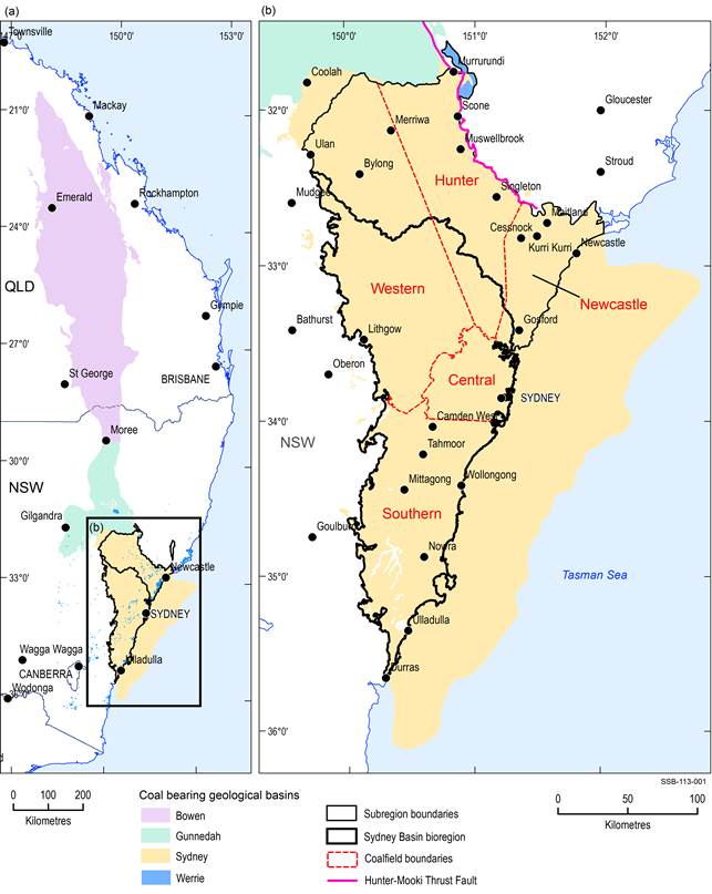
Figure 3 Major coalfields in the geological Sydney Basin within the Sydney Basin bioregion
Data: Geoscience Australia (Dataset 1)
1.2.1.1.1 Southern Coalfield
The geology of the Southern Coalfield consists of the basal Permian Talaterang and Shoalhaven groups, overlain by the Permian Illawarra Coal Measures, and the Triassic Narrabeen Group. These, in turn, are overlain by the Hawkesbury Sandstone, Mittagong Formation and Wianamatta Group. An overview of the general stratigraphy for the Sydney Basin, relevant to coalfields, can be viewed in Section 1.1.3 (Geology) of companion product 1.1 for the Sydney Basin bioregion (Herron et al., 2018). The principal coal resource is situated within the Illawarra Coal Measures, although coal-bearing sequences also occur in the Clyde Coal Measures in the Talaterang Group. Hutton (2009, p. 43) noted there is little possibility of economic coal resources in the Clyde Coal Measures.
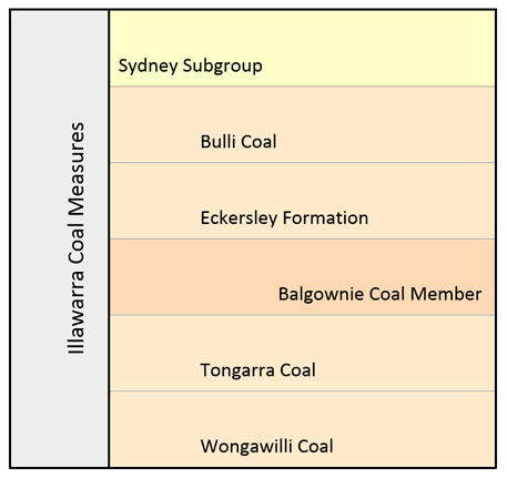
Coal in the Southern Coalfield is utilised as a resource for underground and open-cut mining (Saghafi et al., 2007; Ward and Kelly, 2013) and CSG operations, with gas from coal being extracted within the underground mines in addition to above ground CSG operations (Ward and Kelly, 2013). The coal in the Southern Coalfield differs in rank from the other coalfields of the Sydney Basin. It is generally low to high volatility bituminous coal, in contrast to the medium to high volatility bituminous coal which predominates in other regions (Saghafi et al., 2007). The coal is buried at depths of greater than 300 m in places, though shallower coal is present (Saghafi et al., 2007). Hutton (2009, p. 44) considers the only economic coals to be those of the Sydney Subgroup within the Illawarra Coal Measures, mainly from the Bulli Coal, the Balgownie Coal Member, the Wongawilli Coal and the Tongarra Coal, Darkes Forest, Kembla and Thirroul sandstones (Geoscience Australia, 2015). The Sydney Subgroup (Figure 4) contains all of the economic coal reserves of the Illawarra Coal Measures within the Southern Coalfield (Bamberry, 1991, p. 48). It is composed of conglomerate, sandstone, conglomeratic sandstone, coal, claystone, siltstone and some tuff (Bamberry, 1991, p. 48). The Cumberland Subgroup is considered to contain limited coal making it of little economic significance (Bamberry, 1991, p. 47). This subgroup mainly consists of marine, marginal marine and volcanic latite facies (Bamberry, 1991, p. 47).
The four principal coal-bearing units of the Illawarra Coal Measures are the Bulli, Balgownie, Wongawilli and Tongarra coal units, of which the Bulli Coal and the Wongawilli Coal have the largest resources (Hutton, 2009, p. 44–45; Ward and Kelly, 2013). Other coal members include the Cape Horn, Hargrave, Woronora, American Creek and Woonona; of these the Woonona Seam (correlated to the Lithgow Seam of the Western Coalfield) was previously mined, but is considered to be discontinuous (Hutton, 2009, p. 45). The other coal seams are uneconomic due to the high ash content, low thickness and thin coal intervals in addition to being laterally discontinuous (Hutton, 2009, p. 45). The remaining resource potential is largely in both the Bulli Coal and the Balgownie Coal Member in the Camden-Campbelltown region (Moffitt, 2000, p. 72). The following paragraphs summarise the economic coal interests within the Sydney Subgroup.
1.2.1.1.1.1 Bulli Coal
The Bulli Coal is present throughout most of the Southern Coalfield, but its absence has been documented at the southernmost region of the coalfield and basin (Hutton, 2009, p. 44). It is considered to contain the bulk of the Southern Coalfield’s reserves (Hutton, 2009, p. 44). In addition, the Bulli Coal is the most economic, workable seam, and is extracted through open-cut mining where it reaches the surface in the Wollongong-Coalcliff region in the east (Moffitt, 2000, p. 72; BHP, 2007 p. 2–10). Underground mining is also used to extract the Bulli Coal. Although initial development was restricted to open-cut mines, later shaft and draft mines were opened to allow further mining, though longwall mining is still preferred (Bamberry, 1991, p. 52–56). The Bulli Coal reaches depths of up to 800 m in the central north of the coalfield and is situated at more than 850 m below the surface in the north-west (Moffitt, 2000, p. 72; South 32, 2007, p. 2–10). To the north of the coalfield, the Bulli Coal is 5 m at its thickest and in other regions varies in thickness between 2 and 3 m (Moffitt, 2000, p. 72; Hutton, 2009, p. 44). The thicker sections of the Bulli Coal occur in synclines and down-thrown fault blocks (Moffitt, 2000, p. 72). Seams of the Bulli Coal vary in quality throughout the Southern Coalfield. In some places this coal-bearing unit is absent and in other places, it is described as grading to carbonaceous mudstone (Moffitt, 2000, p. 73).
Like many coal seams within the Southern Coalfield, the Bulli Coal consists of interbanded coal seams, composed of dull and bright plies; in addition to the coal, minor claystone and siderite is present (Bamberry, 1991, p. 56; Hutton, 2009, p. 44). Hutton (2009, p. 44) referred to the Bulli Coal as containing 8 to 9% ash, 21.5 to 27.5% volatile matter, 30 to 55% vitrinite and a high inertinite percentage (55%). However, Bamberry (1991, p. 56) referred to it as a prime quality coking coal with medium to high ash and low to medium volatiles, with an average raw coal production rate of 76%. Armstrong et al. (1995, p. 226) have compiled a more in-depth set of results for the Bulli Coal over two regions that show some variability from the coal parameters above (Table 4). The regional dip of the Bulli Coal towards the north-west is about 2.5 degrees (BHP, 2007, p. 2–10), meaning the coal becomes much deeper below the surface over a relatively short distance. Where igneous intrusive bodies occur near the Bulli Coal, the economic potential has been decreased due to thermal alteration of the coal, particularly in the Mittagong region and the Central Coalfield (Bamberry, 1991, p. 56, 60; Moffitt, 2000, p. 72).
1.2.1.1.1.2 Tongarra Coal
The Tongarra Coal of the Sydney Subgroup (sometimes referred to as the Tongarra Seam) provides an economic resource south of Wollongong where it is mined underground and used in electricity generation; however, it is present in an uneconomic form across the remainder of the Southern Coalfield (Bamberry, 1991, p. 71; Hutton, 2009, p. 45). The coal is interbanded with dull and bright plies and some claystone interbeds (Bamberry, 1991, p. 71; Hutton, 2009, p. 45). Only limited mining of the Tongarra Coal has occurred in the past due to the variability in the properties of the coal and its depth (Bamberry, 1991, p. 71; Moffitt, 2000, p. 75).
Despite this, Moffitt (2000, p. 78) suggested that the Tongarra Coal was economic in the area between the former Huntley Colliery and Sutton Forest. The seam is 1.8 m thick on average, although the working sections vary from between 1.5 m in most of the coalfield to 2.5 m in the south-east (Bamberry, 1991, p. 71). Splitting of the seam occurs to the west between Mittagong and the Warragamba River (Bamberry, 1991, p. 71). Igneous intrusions have resulted in very low coal quality in places due to thermal sterilisation (Bamberry, 1991, p. 71). The Tongarra Coal is not present in the south and south-western margins of the coalfield, although Moffitt (2000, p. 77–78) suggested the lower Wongawilli split is a remnant of the Tongarra Coal.
The Tongarra Coal is reported by Bamberry (1991, p. 71) and Hutton (2009, p. 45) as being medium to high ash coal (35%) with medium volatile and sulfur content; however, Armstrong et al. (1995, p. 226) give the ash content as 15.6%, indicating a higher combustible component. Vitrinite content is reported to be similar to the Wongawilli Coal (Bamberry, 1991, p. 71). The coal’s appearance is that of a bright and dull coal with interbedded tuffaceous and carbonaceous claystone beds (Moffitt, 2000, p. 75).
Table 4 Indicative coal quality for the Illawarra Coal Measures in the Wollongong, Mittagong and Burragorang Valley areas
aas analysed
bdry ash free basis
cdry basis
ddry, mineral matter free
Tr = trace
Data: Armstrong et al. (1995, p. 226)
1.2.1.1.1.3 Wongawilli Coal
The Wongawilli Coal is the second most important coal of economic interest after the Bulli Coal. It is considered to be even more laterally prevalent across the Southern Coalfield than the Bulli Coal (Bamberry, 1991, p. 68; Moffitt, 2000, p75; Hutton, 2009, p. 44). With a maximum thickness of 18 m (varying between 6 and 15 m on average) the Wongawilli Coal is notably thicker than the other seams of the Illawarra Coal Measures (Hutton, 2009, p. 44). The lowermost 3 m of the Wongawilli Coal is mineable throughout the coalfield. Above this, there is a tuffaceous claystone band (the Heights Claystone), which forms a barrier of about 1 m thick between the lower workable 3 m section and the overriding uneconomic portion of the coal (Bamberry, 1991, p. 68; Moffitt, 2000, p. 75; Hutton, 2009, p. 45). Mining was first undertaken through tunnel entries into known outcrop areas. In the south, adit entries were also used to mine the coal (Bamberry, 1991, p. 68). Today, both open-cut and underground mining occur. The Wongawilli Coal is near the surface and in some places outcrops along the south and east of the coalfield and is at a depth of around 900 m in the Central Coalfield (Moffitt, 2000, p76).
The Wongawilli Coal is a highly banded mix of dull and bright coal with carbonaceous and tuffaceous sediments (Bamberry, 1991, p. 68). The upper coal, which is largely uneconomic elsewhere, is mined towards the south of the coalfield, where the quality of the coal improves the economic viability. Ash content is variable, but commonly high. The unit grades from coal to interbedded coal to carbonaceous and tuffaceous rocks (Hutton, 2009, p. 45; Moffitt, 2000, p. 75). The lower, workable coal is bright with disseminated matter and stone bands, and has a vitrinite range of between 60% and 80% (Hutton, 2009, p. 45) and is a moderate to high ash coking coal (Bamberry, 1991, p. 68). Armstrong et al. (1995, p. 226) varied from these statements and provided a more complete view of the petrophysical properties for the Wongawilli Coal (Table 4). The Wongawilli Coal is considered a correlative of the Middle River Coal Member in the Western Coalfield (Hutton, 2009, p. 45). Igneous intrusives have affected a large portion of the mineable coal areas, although in some cases (e.g. at the no longer active Mount Alexander and Mount Waratah Collieries near Mittagong) the intrusion of igneous sills has locally increased coal rank (Bamberry, 1991, p. 68).
1.2.1.1.1.4 Balgownie Coal Member
The Balgownie Coal Member sits within the Eckersley Formation, a unit within the Sydney Subgroup. Bamberry (1991, p. 60) and Moffitt (2000, p. 74) state that the Balgownie Coal Member/Seam is as widespread as the Bulli Coal, but that it lacks its economic thickness. The Balgownie Coal Member is notably thinner than the Bulli Coal, measuring on average between 1.5 and 2 m thick. In some places it is less than 1 m, but has maximum thickness of 3.5 m in the Camden-Campbelltown region (Bamberry, 1991, p. 60; Moffitt, 2000, p. 74; Hutton, 2009, p. 44). The Balgownie Coal Member does reach workable thickness in the north and north-west of the coalfield (Bamberry, 1991, p. 60) and is absent in the south-west of the coalfield (Moffitt, 2000, p. 74). The coal member is interbanded consisting of bright and dull coal with mudstone bands, with siderite and calcite appearing on cleat surfaces (Moffitt, 2000, p. 74). It grades to a higher proportion of carbonaceous mudstone in the north (Moffitt, 2000, p. 74). There has been limited underground mining of the Balgownie Coal Member in the past and it is considered to hold no economic potential towards the south of the Southern Coalfield (Hutton, 2009, p. 44). The area of main economic interest of the Balgownie Coal Member is similar to the Bulli Coal, within the Camden-Campbelltown region (Moffitt, 2000, p. 74).
The Balgownie Coal Member is considered to have similar petrographic properties to the Bulli Coal with an average value ash content (Bamberry, 1991, p. 60), although Hutton (2009, p. 44) reported some high ash contents. Armstrong et al. (1995, p. 226) listed the properties (Table 4) in more detail, showing limited agreement with Bamberry (1991, p. 60) and Hutton (2009, p. 44). Although in proximity to igneous intrusions (Bamberry, 1991, p. 60; Moffitt, 2000, p. 74), the economic significance of the Balgownie Coal Member is not considered to have been impacted by the intrusion as the seam remains thin in the affected regions (Bamberry, 1991, p. 61).
Data: Bamberry (1991, p. 48)
1.2.1.1.2 Western Coalfield
The stratigraphy of the Western Coalfield consists of the Permian Shoalhaven Group, overlain by the Permian Illawarra Coal Measures, which, in turn, are overlain by the Triassic Narrabeen Group. The Narrabeen Group is overlain by the Triassic Hawkesbury Sandstone and the Wianamatta Group. The Illawarra Coal Measures are the only economic coal resource of the Western Coalfield. Underground mining predominates (Brakel, 1991, p. 12) although there are also several open-cut mines (Saghafi et al., 2007).
1.2.1.1.2.1 Illawarra Coal Measures
The Illawarra Coal Measures of the Western Coalfield are subdivided into seven main constituent stratigraphic units (GA and ASC, 2015). These are the Nile Subgroup, Cullen Bullen Subgroup, Charbon Subgroup, Wallerawang Subgroup and State Mine Creek Formation, as well as the Lithgow Coal and the Irondale Coal (Geoscience Australia and Australian Stratigraphy Commission, 2015). Further internal divisions of the Cullen Bullen Subgroup, Charbon Subgroup, State Mine Creek Formation and Wallerawang Subgroup can be viewed in Figure 5, relevant to the Western Coalfield (Australian Stratigraphic Database, 2015). However due to differences in the stratigraphic hierarchy between authors, industry and governing bodies, the coal of the Western Coalfield is at times divided into four main divisions (Wallerawang, Charbon, Cullen Bullen and Nile subgroups) where the State Mine Creek Formation, Lithgow and Irondale coals are placed within other subgroups (Huleatt 1991, p. 39; Yoo et al., 1995, p. 243; RW Corkery & Co Pty Limited, 2008, p. 9; RW Corkery & Co Pty Limited, 2012, p. 8; Hutton 2009, p. 53; Centennial Coal, 2012, p. 7).
The Nile Subgroup contains no notable economic coal resources (Huleatt, 1991, p. 39). The thickness of the Illawarra Coal Measures of the Western Coalfield ranges between 50 m in the vicinity of Ulan (within the western part of the Hunter subregion) to 900 m near Wisemans Ferry, west of Gosford (Ward and Kelly, 2013). The Lithgow Coal, Lidsdale Coal, Ulan Coal and Katoomba Coal Member are of main economic interest in the Western Coalfields, with Irondale Coal and Middle River Coal Member locally important (Hutton, 2009, p. 53; Ward and Kelly, 2013). Hutton (2009, p. 53) also proposed that the Moolarben Coal Member was of some interest (Hutton, 2009, p. 53); it is mined at Charbon (RW Corkery & Co Pty Limited, 2008, p. 8).
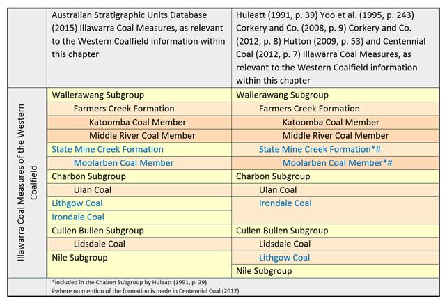
The Australian Stratigraphic Units Database (Geoscience Australia and Australian Stratigraphy Commission, 2015) lists seven key constituents: Wallerawang, Charbon, Cullen Bullen and Nile subgroups, along with the State Mine Creek Formation, and the Lithgow and Irondale Coals, whereas many publications list the State Mine Creek Formation, and the Irondale Coal and the Lithgow Coal as belonging to one of the four subgroups.
Data: Geoscience Australia and Australian Stratigraphy Commission (2015), Huleatt (1991), Yoo et al. (1995, p. 243), RW Corkery & Co Pty Limited (2008), RW Corkery & Co Pty Limited (2012), Hutton (2009, p. 53), Centennial Coal (2012).
Middle River Coal Member
Part of the Farmers Creek Formation within the Wallerawang Subgroup, the Middle River Coal Member, forms coal seams of up to 4 m of high ash content and vitrinite dominated coal (Hutton, 2009, p. 53). It is correlated to the Wongawilli Coal of the Southern Coalfield and is generally classed as uneconomic (Hutton, 2009, p. 53). Yoo et al. (1995, p. 243), however, suggested that there was potential for economic recovery in the Newnes Plateau region where borehole data indicated a 2 m thick coal with ash content of less than 35%. RW Corkery & Co Pty Limited (2008, p. 8) referred to the localised thickness of the Middle River Coal Member as being between 7 and 8 m in thickness at the Charbon Colliery. The coal in the Charbon region has high ash content (less than 40%), where the coal is interbanded with claystone and carbonaceous shale, and the lowermost section of the seam is considered to contain more coal (RW Corkery & Co Pty Limited, 2008, p. 8). It is currently mined using underground and open-cut methods.
Katoomba Coal Member
The Katoomba Coal Member, which is also part of the Farmers Creek Formation, has a highly variable thickness, varying from absent in some places to 6 m thick in other places and is correlated to the Southern Coalfield Bulli Coal (Hutton, 2009, p. 53). However, Yoo et al. (1995, p. 243) have stated that the thickness ranges from 1.5 to 3 m. There is very minor claystone content within this coal-bearing unit (Yoo et al., 1995, p. 243; Hutton, 2009, p. 53) and it is considered a significant coal resource that is mined in the south and south-east of the Western Coalfield (Hutton, 2009, p. 53) where Yoo et al. (1995, p. 243) listed it as being significant. This coal is not present to the north and east of the Lithgow region due to surface erosion (Hutton, 2009, p. 53). The Katoomba Coal Member is also noted as being present east of Rylstone (north of Lithgow), where it ranges in thickness from 1 to 10 m and claystone bands are common.
The ash content varies from 11% to 23% (Yoo et al., 1995, p. 243; Hutton, 2009, p. 53) and volatile matter is reported as 28.9% (Hutton, 2009, p. 53). Yoo et al. (1995, p. 243) considered it to have low sulfur and high inertinite. The Katoomba Coal Member has been mined through underground methods in the Bell and Birds Rock-Newnes Junction regions (Yoo et al., 1995, p. 243).
Moolarben Coal Member
The Moolarben Coal Member is part of the State Mine Creek Formation. Hutton (2009, p. 53) described the Moolarben Coal Member (also referred to as the Moolarben Seam) as a narrow coal seam (less than 1 m, increasing to roughly 3 m in the Ulan region) of no visible economic potential. However, Yoo et al., (1995, p. 243) found that to the east of Ulan, the coal is 3.17 m thick (Hunter subregion) and described it as a dull coal with some bright plies, more notable in the lower section with several claystone beds. In the Moolarben area between Ulan Colliery and Wollar, the Moolarben Coal Member is considered to be a potential economic resource (Yoo et al., 1995, p. 243). The variation in thickness continues in the Bylong area of the Hunter subregion where the coal is noted as being 4.9 m thick (Yoo et al., 1995, p. 243). Changes in the composition of the Moolarben Coal Member are also noted from the coal described in the area east of Ulan (see above) with the measures at Bylong described as coal, claystone and carbonaceous claystone (Yoo et al., 1995, p. 243). Additionally, the Moolarben Coal Member is described as being ‘coal-barren’, composed of tuffaceous mudstone and claystone, at the Moolarben Coal Mine (Mine Subsidence Engineering Consultants, 2008, p. 8) suggesting that a wide variability in quality and lithology affects the economic potential of the Moolarben Coal Member.
Yoo et al. (1995, p. 243) found the coal member, where measured, has a high ash content (27% to 34%), and stated that small recovery through open-cut operations may be an option but this is most likely to be only within the Moolarben and Cockaburra Creek areas.
Lithgow Coal
The Lithgow Coal, as identified by the Australian Stratigraphic Units Database (Geoscience Australia and Australian Stratigraphy Commission, 2015), is a stand-alone unit of the Illawarra Coal Measures, although many publications (Huleatt, 1991, p. 39; Yoo et al., 1995, p. 243; RW Corkery & Co Pty Limited, 2008, p. 9; Hutton, 2009, p. 53; Centennial Coal, 2012, p. 7; RW Corkery & Co Pty Limited, 2012, p. 8) identify it as being the Lithgow Seam of the Cullen Bullen Subgroup.
Varying from 1 to 7 m thick, most mineable sections of the Lithgow Coal are between 2 and 4 m thick (Hutton, 2009, p. 53). However, Centennial Coal (2012, p. 6) stated that the Lithgow Coal (seam) varies from 1 to 9 m in thickness across the Western Coalfield. Yoo et al. (1995, p. 236) and Centennial Coal (2012, p. 6) reported that the Lithgow Coal is a major resource, particularly in the Rylstone, Bylong and Lithgow areas. The Lithgow Coal is composed of dull coal, interbedded with carbonaceous claystone layers that are most common in the middle to upper sections (Yoo et al., 1995, p. 236). Minor bright bands of coal and conglomerate have also been identified as interbeds (Centennial Coal, 2012, p. 6). The coal has been extensively mined by underground and open-cut methods. The Lithgow Coal can be correlated to the Ulan Coal of the same coalfield (Hutton, 2009, p. 53).
At Bylong, the Lithgow Coal is dull with limited stone bands. Thinning is noted in this area as the coal is traced to the west, with thickening to the east to 5 m, where the ash content is less than 20% (Yoo et al, 1995, p. 241). Hutton (2009, p.53) reported that the Lithgow Coal has a low vitrinite content, moderate volatile matter and an ash content of 10% to 25% in southern areas of the coalfield where it is mined. In contrast, Yoo et al. (1995, p.241) stated that the Lithgow Coal has high levels of volatile matter and ash content of 14% to 35%, with low amounts of sulfur.
Irondale Coal
The Irondale Coal, as identified by the Australian Stratigraphic Units Database (Geoscience Australia and Australian Stratigraphy Commission, 2015), is a stand-alone unit of the Illawarra Coal Measures, though many publications (Huleatt, 1991, p. 39; Yoo et al., 1995, p. 243; RW Corkery & Co Pty Limited, 2008, p. 9; Hutton, 2009, p. 53; Centennial Coal, 2012, p. 7; RW Corkery & Co Pty Limited, 2012, p. 8) identify it as being the Irondale Seam of the Charbon Subgroup.
The Irondale Coal (or Wolgan Seam) has a maximum thickness of over 2 m in the Wolgan area although typically the Irondale Coal is around 1 m in thickness (Hutton, 2009, p. 53). The coal of this unit contains both dull and bright bands in addition to stone bands (Yoo et al., 1995, p. 238). It is reportedly correlated to the Ulan Coal (Yoo et al., 1995, p. 238). Mining has taken place to a small degree using open-cut and underground methods (Yoo et al., 1995, p. 238). Yoo et al. (1995, p. 238) noted that there was greater potential for economic recovery in the Wolgan and Cherry Tree Hill areas. The ash content of this seam is 10.8% and the vitrinite content is 35.7% (Hutton, 2009, p. 53). The coal in Wolgan area is considered to be highly volatile with a 9% to 11% ash content (Yoo et al., 1995, p238).
Lidsdale Coal
Sometimes referenced as being a split of the Lithgow Coal, the Lidsdale Coal within the Cullen Bullen Subgroup has similar properties to the Lithgow Coal (Hutton, 2009, p. 53). Hutton (2009, p. 53) referred to the Lidsdale Coal as a dull coal, broken by carbonaceous shale layers and as only being present to the west of the coalfield. However, Yoo et al. (1995, p. 241) stated that it occurs throughout the Western Coalfield. Sections have been previously mined, where the thickness reached 2 to 3 m in the Rylstone area (Yoo et al., 1995, p241; Hutton, 2009, p. 53). It is was previously mined at Charbon and Ivanhoe mines where the ash content ranges from 20% to 32% (Yoo et al., 1995, p. 241).
Ulan Coal
The Ulan Coal, within the Charbon Subgroup, sits within a thin, tuffaceous, claystone layer and has a thickness of around 14 to 15 m (Mine Subsidence Engineering Consultants, 2008, p. 8; Hutton, 2009, p. 53). The lower section is up to 7 m thick with ash content reported between 7% and 13%. The upper section is up to 7 m thick with ash content ranging from 11% to 45% (Yoo et al., 1995, p. 243). To the north of the Western Coalfield the Ulan Coal has an ash content of between 11% and 13% where coal is mined underground (Hutton, 2009, p. 53). Open-cut mining has also taken place in the area. The Ulan Coal is correlated to the Lithgow Coal of the same coalfield (Hutton, 2009, p. 53).
